TOYOTA VENZA 2014 Accessories, Audio & Navigation (in English)
Manufacturer: TOYOTA, Model Year: 2014, Model line: VENZA, Model: TOYOTA VENZA 2014Pages: 228, PDF Size: 3.73 MB
Page 61 of 228
61
2
APPLICATION-“Map”
5. NAVIGATION SETTING
1. MAP SETTINGS
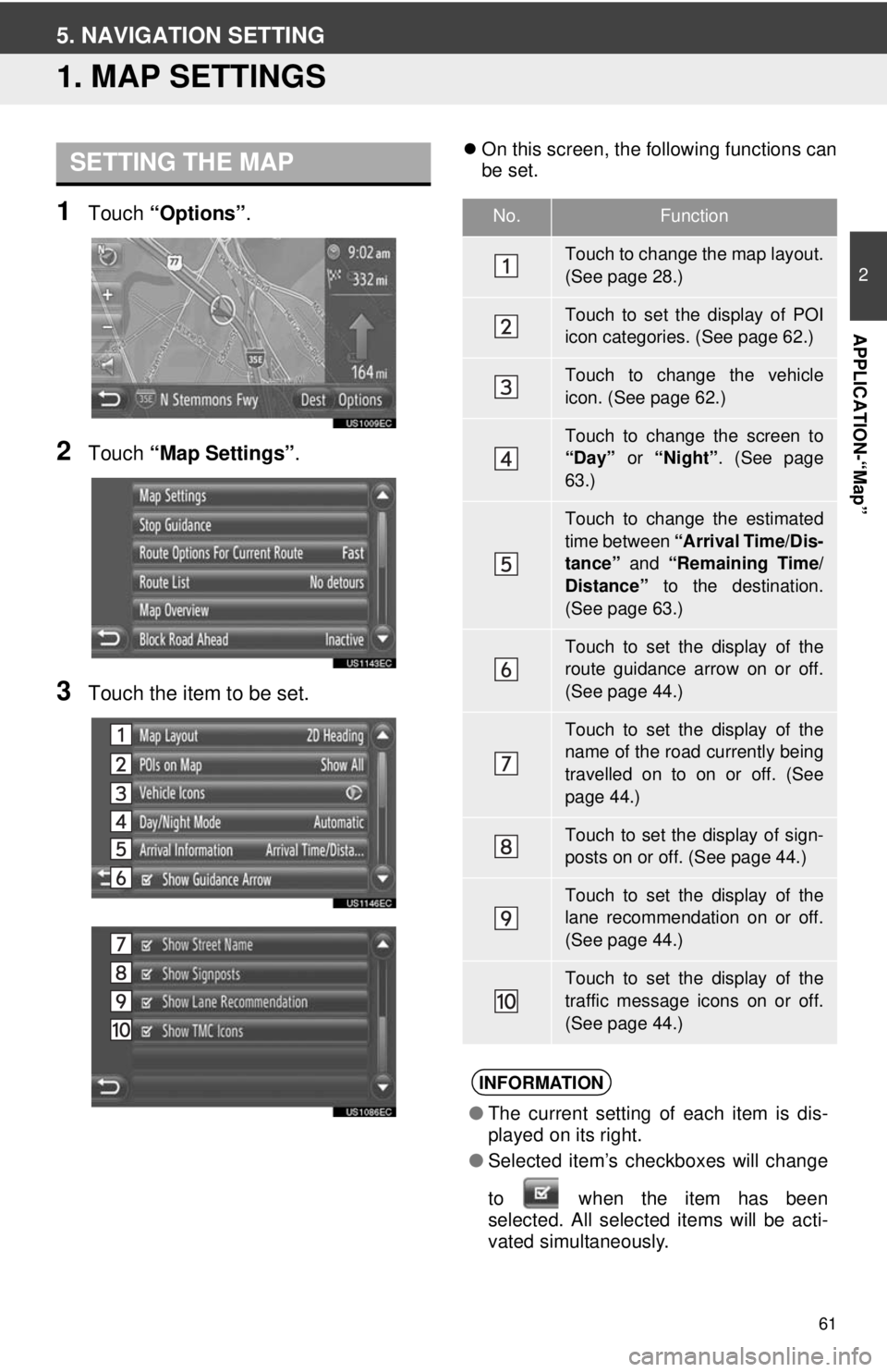
1Touch “Options”.
2Touch “Map Settings” .
3Touch the item to be set.
On this screen, the following functions can
be set.SETTING THE MAP
No.Function
Touch to change the map layout.
(See page 28.)
Touch to set the display of POI
icon categories. (See page 62.)
Touch to change the vehicle
icon. (See page 62.)
Touch to change the screen to
“Day” or “Night”. (See page
63.)
Touch to change the estimated
time between “Arrival Time/Dis-
tance” and “Remaining Time/
Distance” to the destination.
(See page 63.)
Touch to set the display of the
route guidance arrow on or off.
(See page 44.)
Touch to set the display of the
name of the road currently being
travelled on to on or off. (See
page 44.)
Touch to set the display of sign-
posts on or off. (See page 44.)
Touch to set the display of the
lane recommendation on or off.
(See page 44.)
Touch to set the display of the
traffic message icons on or off.
(See page 44.)
INFORMATION
● The current setting of each item is dis-
played on its right.
● Selected item’s checkboxes will change
to when the item has been
se
lected. All selected items will be acti-
vated simultaneously.
Page 62 of 228
62
5. NAVIGATION SETTING
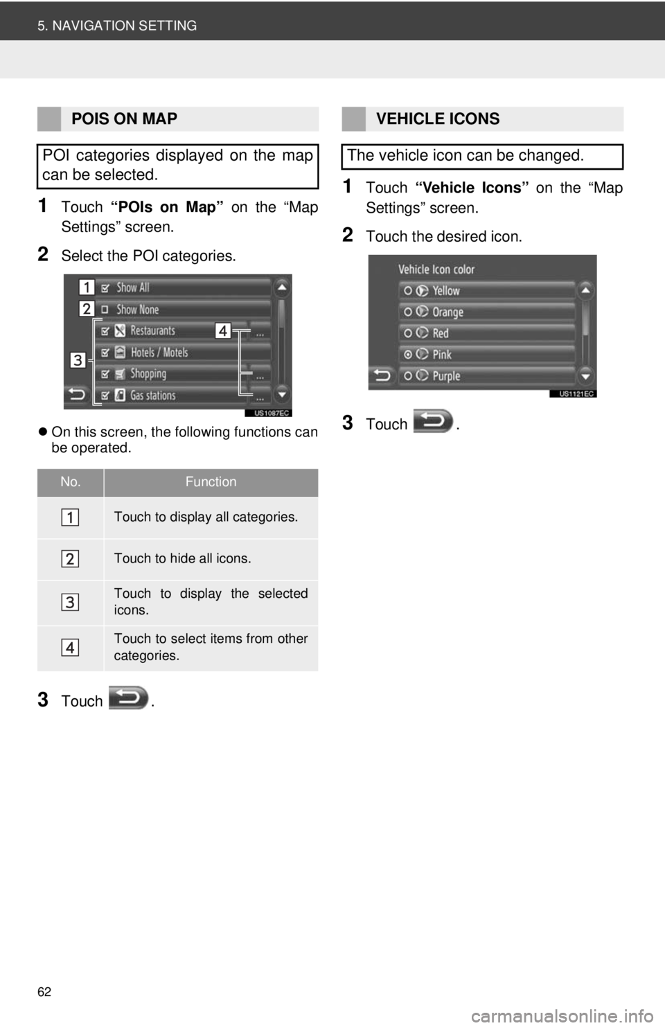
1Touch “POIs on Map” on the “Map
Settings” screen.
2Select the POI categories.
On this screen, the following functions can
be operated.
3Touch .
1Touch “Vehicle Icons” on the “Map
Settings” screen.
2Touch the desired icon.
3Touch .
POIS ON MAP
POI categories displayed on the map
can be selected.
No.Function
Touch to display all categories.
Touch to hide all icons.
Touch to display the selected
icons.
Touch to select items from other
categories.
VEHICLE ICONS
The vehicle icon can be changed.
Page 63 of 228
63
5. NAVIGATION SETTING
2
APPLICATION-“Map”
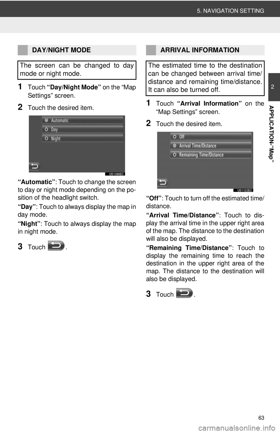
1Touch “Day/Night Mode” on the “Map
Settings” screen.
2Touch the desired item.
“Automatic” : Touch to change the screen
to day or night mode depending on the po-
sition of the headlight switch.
“Day” : Touch to always display the map in
day mode.
“Night”: Touch to always display the map
in night mode.
3Touch .
1Touch “Arrival Information” on the
“Map Settings” screen.
2Touch the desired item.
“Off” : Touch to turn off the estimated time/
distance.
“Arrival Time/Distance” : Touch to dis-
play the arrival time in the upper right area
of the map. The dist ance to the destination
will also be displayed.
“Remaining Time/Distance” : Touch to
display the remaining time to reach the
destination in the upper right area of the
map. The distance to the destination will
also be displayed.
3Touch .
DAY/NIGHT MODE
The screen can be changed to day
mode or night mode.ARRIVAL INFORMATION
The estimated time to the destination
can be changed between arrival time/
distance and remaining time/distance.
It can also be turned off.
Page 64 of 228
64
5. NAVIGATION SETTING
2. ROUTE SETTINGS
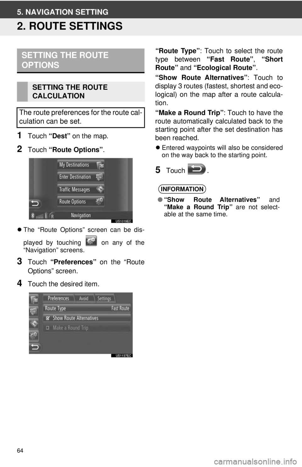
1Touch “Dest” on the map.
2Touch “Route Options” .
The “Route Options” screen can be dis-
played by touching on any of the
“Navigation” screens.
3Touch “Preferences” on the “Route
Options” screen.
4Touch the desired item. “Route Type”
: Touch to select the route
type between “Fast Route”, “Short
Route” and “Ecological Route” .
“Show Route Alternatives” : Touch to
display 3 routes (fastest, shortest and eco-
logical) on the map after a route calcula-
tion.
“Make a Round Trip” : Touch to have the
route automatically calculated back to the
starting point after the set destination has
been reached.
Entered waypoints will also be considered
on the way back to the starting point.
5Touch .
SETTING THE ROUTE
OPTIONS
SETTING THE ROUTE
CALCULATION
The route preferences for the route cal-
culation can be set.
INFORMATION
● “Show Route Alternatives” and
“Make a Round Trip” are not select-
able at the same time.
Page 65 of 228
65
5. NAVIGATION SETTING
2
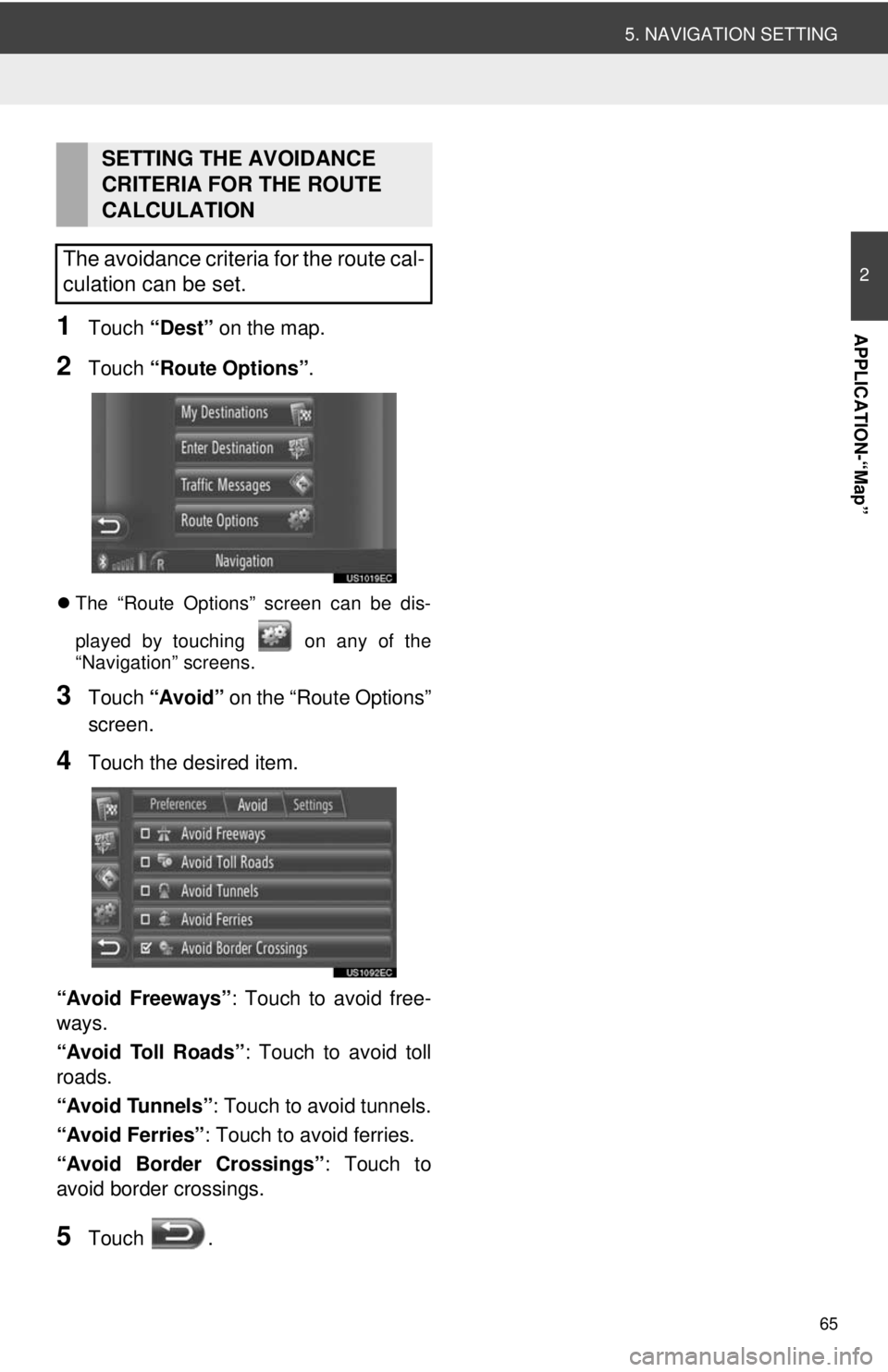
APPLICATION-“Map”1Touch “Dest” on the map.
2Touch “Route Options” .
The “Route Options” screen can be dis-
played by touching on any of the
“Navigation” screens.
3Touch “Avoid” on the “Route Options”
screen.
4Touch the desired item.
“Avoid Freeways” : Touch to avoid free-
ways.
“Avoid Toll Roads” : Touch to avoid toll
roads.
“Avoid Tunnels” : Touch to avoid tunnels.
“Avoid Ferries” : Touch to avoid ferries.
“Avoid Border Crossings” : Touch to
avoid border crossings.
5Touch .
SETTING THE AVOIDANCE
CRITERIA FOR THE ROUTE
CALCULATION
The avoidance criteria for the route cal-
culation can be set.
Page 66 of 228
66
6. NAVIGATION SYSTEM INFORMATION
1. LIMITATIONS OF THE NAVIGATION SYSTEM
The Global Positioning System (GPS) de-
veloped and operated by the U.S. Depart-
ment of Defense provides an accurate
current vehicle position, normally using 4
or more satellites, and in some case 3 sat-
ellites. The GPS system has a certain level
of inaccuracy. While the navigation system
will compensate for this most of the time,
occasional positioning errors of up to 300
feet (100 m) can and should be expected.
Generally, position errors will be corrected
within a few seconds.
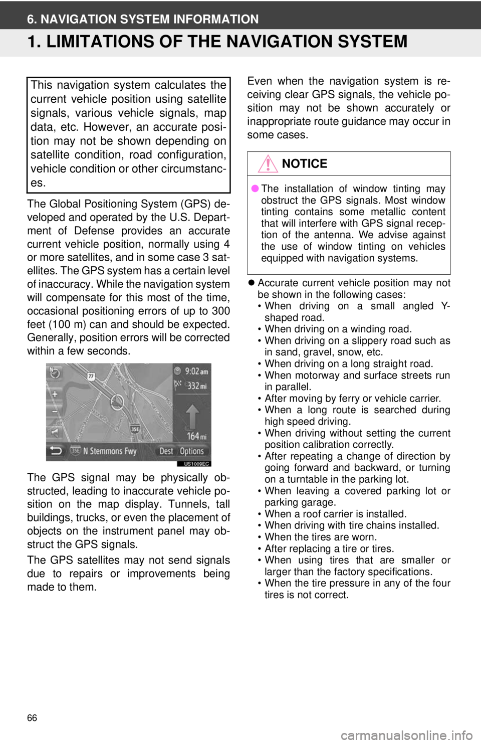
The GPS signal may be physically ob-
structed, leading to inaccurate vehicle po-
sition on the map display. Tunnels, tall
buildings, trucks, or even the placement of
objects on the instrument panel may ob-
struct the GPS signals.
The GPS satellites may not send signals
due to repairs or improvements being
made to them. Even when the navigation system is re-
ceiving clear GPS signals, the vehicle po-
sition may not be shown accurately or
inappropriate route guidance may occur in
some cases.
Accurate current vehicle position may not
be shown in the following cases:
• When driving on a small angled Y-
shaped road.
• When driving on a winding road.
• When driving on a slippery road such as in sand, gravel, snow, etc.
• When driving on a long straight road.
• When motorway and surface streets run in parallel.
• After moving by ferry or vehicle carrier.
• When a long route is searched during high speed driving.
• When driving without setting the current position calibration correctly.
• After repeating a change of direction by
going forward and backward, or turning
on a turntable in the parking lot.
• When leaving a covered parking lot or
parking garage.
• When a roof carrier is installed.
• When driving with tire chains installed.
• When the tires are worn.
• After replacing a tire or tires.
• When using tires that are smaller or
larger than the factory specifications.
• When the tire pressure in any of the four tires is not correct.
This navigation system calculates the
current vehicle position using satellite
signals, various vehicle signals, map
data, etc. However, an accurate posi-
tion may not be shown depending on
satellite condition, road configuration,
vehicle condition or other circumstanc-
es.
NOTICE
● The installation of window tinting may
obstruct the GPS signals. Most window
tinting contains some metallic content
that will interfere with GPS signal recep-
tion of the antenna. We advise against
the use of window tinting on vehicles
equipped with navigation systems.
Page 67 of 228
67
6. NAVIGATION SYSTEM INFORMATION
2
APPLICATION-“Map”
Inappropriate route guidance may occur in
the following cases:
• When turning at an intersection off the
designated route guidance.
• If you set more than one destination but
skip one of them, auto reroute will dis-
play a route returning to the destination
that was skipped.
• When turning at an intersection for which there is no route guidance.
• When passing through an intersection
for which there is no route guidance.
• During auto reroute, the route guidance may not be available for the next turn to
the right or left.
• It may take a long time to operate auto reroute during high speed driving. In
auto reroute, a detour route may be
shown.
• After auto reroute, the route may not be
changed.
• An unnecessary U-turn may be shown or announced.
• A location may have multiple names and the system will announce one or more.
• Some routes may not be searched.
• If the route to your destination includes gravel, unpaved roads or alleys, the
route guidance may not be shown.
• Your destination point might be shown on the opposite side of the street.
• When a portion of the route has regula-
tions prohibiting the entry of the vehicle
that vary by time or season or other rea-
sons.
• The road and map data stored in the navigation system may not be complete
or may not be the latest version.
INFORMATION
● This navigation system uses tire turning
data and is designed to work with fac-
tory-specified tires for the vehicle.
Installing tires that are larger or smaller
than the originally equipped diameter
may cause inaccurate display of the cur-
rent vehicle position. The tire pressure
also affects the diameter of the tires so
make sure the tire pressure of all four
tires is correct.
Page 68 of 228
68
6. NAVIGATION SYSTEM INFORMATION
2. MAP INFORMATION
END-USER TERMS
The data (“Data”) is provided for your
personal, internal use only and not for
resale. It is protected by copyright, and
is subject to the following terms and
conditions which are agreed to by you,
on the one hand, and Harman
(“Harman”) and its licensors (including
their licensors and suppliers) on the
other hand.
© 2011 NAVTEQ B.V., © Bundesamt
für Eich- und Vermessungswesen, ©
EuroGeographics, source: © IGN 2009
– BD TOPO
®, Die Grundlagendaten
wurden mit
Genehmigung der zustaendigen
Behoerden entnommen, Contains
Ordnance Survey data © Crown
copyright and database right 2010
Contains Royal Mail data © Royal Mail
copyright and database right 2010,
Copyright Geomatics Ltd., Copyright ©
2003; Top-Map Ltd., La Banca Dati
Italiana è stata prodotta usando quale
riferimento anche cartografia numerica
ed al tratto prodotta e fornita dalla
Regione Toscana., Copyright © 2000;
Norwegian Mapping Authority, Source:
IgeoE – Portugal, Información
geográfica propiedad del CNIG, Based
upon electronic data Ó National Land
Survey Sweden., Topografische
Grundlage: Ó Bundesamt für
Landestopographie.. All rights
reserved.
TERMS AND CONDITIONS
PLEASE READ THIS END USER
LICENSE AGREEMENT
CAREFULLY BEFORE USING THE
NAVTEQ DATABASE
NOTICE TO THE USER
THIS IS A LICENSE AGREEMENT -
AND NOT AN AGREEMENT FOR
SALE – BETWEEN YOU AND
NAVTEQ B.V. FOR YOUR COPY OF
THE NAVTEQ NAVIGABLE MAP
DATA-BASE, INCLUDING
ASSOCIATED COMPUTER
SOFTWARE, MEDIA AND
EXPLANATORY PRINTED
DOCUMENTATION PUBLISHED BY
NAVTEQ (JOINTLY “THE
DATABASE”). BY USING THE
DATABASE, YOU ACCEPT AND
AGREE TO ALL TERMS AND
CONDITIONS OF THIS END USER
LICENSE AGREEMENT
(“AGREEMENT”). IF YOU DO NOT
AGREE TO THE TERMS OF THIS
AGREEMENT, PROMPTLY RETURN
THE DATABASE, ALONG WITH ALL
OTHER ACCOMPANYING ITEMS,
TO YOUR SUP-PLIER FOR A
REFUND.
OWNERSHIP
The Database and the copyrights and
intellectual property or neighboring
rights therein are owned by NAVTEQ
or its licensors. Ownership of the media
on which the Database is contained is
retained by NAVTEQ and/or your
supplier until after you have paid in full
any amounts due to NAVTEQ and/or
your supplier pursuant to this
Agreement or similar agreement(s)
under which goods are provided to you.
Page 69 of 228
69
6. NAVIGATION SYSTEM INFORMATION
2
APPLICATION-“Map”
LICENSE GRANT
NAVTEQ grants you a non-exclusive
license to use the Database for your
personal use or, if applicable, for use in
your business’ internal operations. This
license does not include the right to
grant sub-licenses.
LIMITATIONS ON USE
The Database is restricted for use in
the specific system for which it was
created. Except to the extent explicitly
permitted by mandatory laws (e.g.
national laws based on the European
Software Directive (91/250) and the
Database Directive (96/9)), you may
not extract or reutilize substantial parts
of the contents of the Database nor
reproduce, copy, modify, adapt,
translate, disassemble, decompile,
reverse engineer any portion of the
Database. If you wish to obtain
interoperability information as meant in
(the national laws based on) the
European Software Directive, you shall
grant NAVTEQ reasonable opportunity
to provide said information on
reasonable terms, including costs, to
be determined by NAVTEQ.
TRANSFER OF LICENSE
You may not transfer the Database to
third parties, except when installed in
the system for which it was created or
when you do not retain any copy of the
Database, and provided that the
transferee agrees to all terms and
conditions of this Agreement and
confirms this in writing to NAVTEQ.
Multi-disc sets may only be transferred
or sold as a complete set as provided
by NAVTEQ and not as subset thereof.LIMITED WARRANTY
NAVTEQ warrants that, subject to the
warnings set out below, for a period of
12 months after acquisition of your
copy of the Database, it will perform
substantially in accordance with
NAVTEQ’s Criteria for Accuracy and
Completeness existing on the date you
acquired the Database; these criteria
are available from NAVTEQ at your
request. If the Database does not
perform in accordance with this limited
warranty, NAVTEQ will use reasonable
efforts to repair or replace your non-
conforming copy of the Database. If
these efforts do not lead to
performance of the Database in
accordance with the warranties set out
herein, you will have the option to either
receive a reasonable refund of the
price you paid for the Database or to
rescind this Agreement. This shall be
NAVTEQ’s entire liability and your sole
remedy against NAVTEQ. Except as
expressly provided in this section,
NAVTEQ does not warrant nor make
any representations regarding the use
of results of the use of the Database in
terms of its correctness, accuracy,
reliability, or otherwise. NAVTEQ does
not warrant that the Database is or will
be error free. No oral or written
information or advice provided by
NAVTEQ, your supplier or any other
person shall create a warranty or in any
way increase the scope of the limited
warranty described above. The limited
warranty set forth in this Agreement
does not affect or prejudice any
statutory legal rights that you may have
under the legal warranty against
hidden defects.
Page 70 of 228
70
6. NAVIGATION SYSTEM INFORMATION
If you did not acquire the Database
from NAVTEQ directly, you may have
statutory rights against the person from
whom you have acquired the Database
in addition to the rights granted by
NAVTEQ hereunder according to the
law of your jurisdiction. The above
warranty of NAVTEQ shall not affect
such statutory rights and you may
assert such rights in addition to the
warranty rights granted herein.
LIMITATION OF LIABILITY
The price of the Database does not
include any consideration for
assumption of risk of consequential,
indirect or unlimited direct damages
which may arise in connection with
your use of the Database. Accordingly,
in no event shall NAVTEQ be liable for
any consequential or indirect damages,
including without limitation, loss of
revenue, data, or use, incurred by you
or any third party arising out of your use
of the Database, whether in an action in
contract or tort or based on a warranty,
even if NAVTEQ has been advised of
the possibility of such damages. In any
event NAVTEQ’s liability for direct
damages is limited to the price of your
copy of the Database.
THE LIMITED WARRANTY AND
LIMITATION OF LIABILITY, SET
FORTH IN THIS AGREE-MENT, DO
NOT AFFECT OR PREJUDICE YOUR
STATUTORY RIGHTS WHERE YOU
HAVE ACQUIRED THE DATABASE
OTHERWISE THAN IN THE COURSE
OF A BUSINESS.WARNINGS
The Database may contain inaccurate
or incomplete information due to the
passage of time, changing
circumstances, sources used and the
nature of collecting comprehensive
geographic data, any of which may
lead to incorrect results. The Database
does not include or reflect information
on - inter alia - neighborhood safety;
law enforcement; emergency
assistance; construction work; road or
lane closures; vehicle or speed
restrictions; road slope or grade; bridge
height, weight or other limits; road or
traffic conditions; special events; traffic
congestion; or travel time.
GOVERNING LAW
This Agreement shall be governed by
the laws of the jurisdiction, in which you
reside at the date of acquisition of the
Database. Should you at that moment
reside outside the European Union or
Switzerland, the law of the jurisdiction
within the European Union or
Switzerland where you acquired the
Database shall apply. In all other
cases, or if the jurisdiction where you
acquired the Database cannot be
defined, the laws of the Netherlands
shall apply. The courts competent at
your place of residence at the time you
acquired the Database shall have
jurisdiction over any dispute arising out
of, or relating to this Agreement,
without prejudice to NAVTEQ’ right to
bring claims at your then current place
of residence.