display HONDA ODYSSEY 2014 RC1-RC2 / 5.G Navigation Manual
[x] Cancel search | Manufacturer: HONDA, Model Year: 2014, Model line: ODYSSEY, Model: HONDA ODYSSEY 2014 RC1-RC2 / 5.GPages: 327, PDF Size: 19.96 MB
Page 77 of 327
76
Map
Map Legend
System Setup
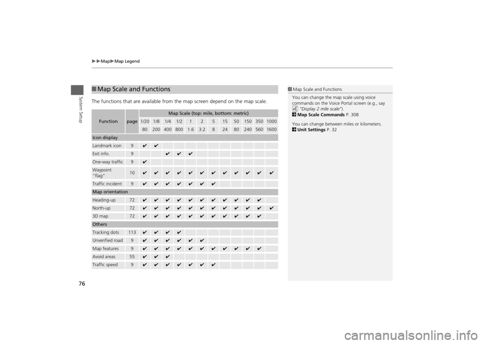
The functions that are available from the map screen depend on the map scale.■Map Scale and Functions
Function
page
Map Scale (top: mile, bottom: metric)
1/20
1/8
1/4
1/2
1
2
5
15
50
150
350
1000
80
200
400
800
1.6
3.2
8
24
80
240
560
1600
Icon displayLandmark icon
9
✔
✔
Exit info.
9
✔
✔
✔
One-way traffic
9
✔
Waypoint
“flag”
10
✔
✔
✔
✔
✔
✔
✔
✔
✔
✔
✔
✔
Traffic incident
9
✔
✔
✔
✔
✔
✔
✔
Map orientationHeading-up
72
✔
✔
✔
✔
✔
✔
✔
✔
✔
✔
✔
North-up
72
✔
✔
✔
✔
✔
✔
✔
✔
✔
✔
✔
✔
3D map
72
✔
✔
✔
✔
✔
✔
✔
✔
✔
✔
✔
OthersTracking dots
113
✔
✔
✔
✔
Unverified road
9
✔
✔
✔
✔
✔
✔
Map features
9
✔
✔
✔
✔
✔
✔
✔
✔
✔
✔
✔
Avoid areas
55
✔
✔
✔
Traffic speed
9
✔
✔
✔
✔
✔
✔
✔
1Map Scale and Functions
You can change the map scale using voice
commands on the Voice Portal screen (e.g., say
d “Display 2 mile scale”).
2Map Scale Commands P. 308
You can change between miles or kilometers.
2Unit Settings P. 32
Page 78 of 327
77
Map
Map Legend
System Setup
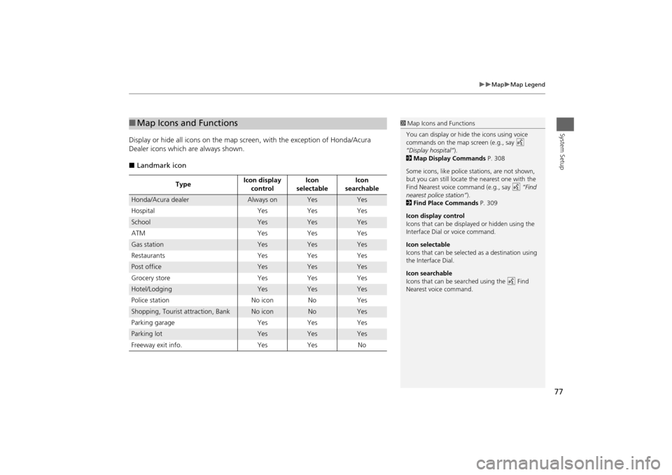
Display or hide all icons on the map screen, with the exception of Honda/Acura
Dealer icons which are always shown.
■Landmark icon■Map Icons and Functions
TypeIcon display
controlIcon
selectableIcon
searchable
Honda/Acura dealer
Always on
Yes
Yes
Hospital Yes Yes Yes
School
Yes
Yes
Yes
ATM Yes Yes Yes
Gas station
Yes
Yes
Yes
Restaurants Yes Yes Yes
Post office
Yes
Yes
Yes
Grocery store Yes Yes Yes
Hotel/Lodging
Yes
Yes
Yes
Police station No icon No Yes
Shopping, Tourist attraction, Bank
No icon
No
Yes
Parking garage Yes Yes Yes
Parking lot
Yes
Yes
Yes
Freeway exit info. Yes Yes No
1Map Icons and Functions
You can display or hide the icons using voice
commands on the map screen (e.g., say d
“Display hospital”).
2Map Display Commands P. 308
Some icons, like police stations, are not shown,
but you can still locate the nearest one with the
Find Nearest voice command (e.g., say d “Find
nearest police station”).
2Find Place Commands P. 309
Icon display control
Icons that can be displayed or hidden using the
Interface Dial or voice command.
Icon selectable
Icons that can be selected as a destination using
the Interface Dial.
Icon searchable
Icons that can be searched using the d Find
Nearest voice command.
Page 79 of 327
78
Map
Map Legend
System Setup
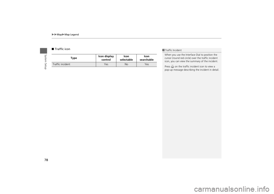
■Traffic icon
TypeIcon display
controlIcon
selectableIcon
searchable
Traffic incident
Yes
No
Yes
1Traffic Incident
When you use the Interface Dial to position the
cursor (round red circle) over the traffic incident
icon, you can view the summary of the incident.
Press u on the traffic incident icon to view a
pop-up message describing the incident in detail.
Page 80 of 327
79
Map
Display Tracking
System Setup
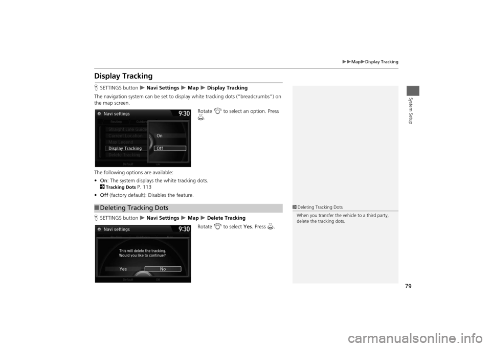
Display TrackingHSETTINGS button
Navi Settings
Map
Display Tracking
The navigation system can be set to display white tracking dots (“breadcrumbs”) on
the map screen.
Rotate i to select an option. Press
u.
The following options are available:
•On: The system displays the white tracking dots.
2
Tracking Dots
P. 113
•Off (factory default): Disables the feature.
HSETTINGS button Navi Settings
Map
Delete Tracking
Rotate i to select Yes. Press u.
■Deleting Tracking Dots
1Deleting Tracking Dots
When you transfer the vehicle to a third party,
delete the tracking dots.
Page 81 of 327
80
Map
Correct Vehicle Position
System Setup
Correct Vehicle PositionHSETTINGS button
Navi Settings
Map
Correct Vehicle Position
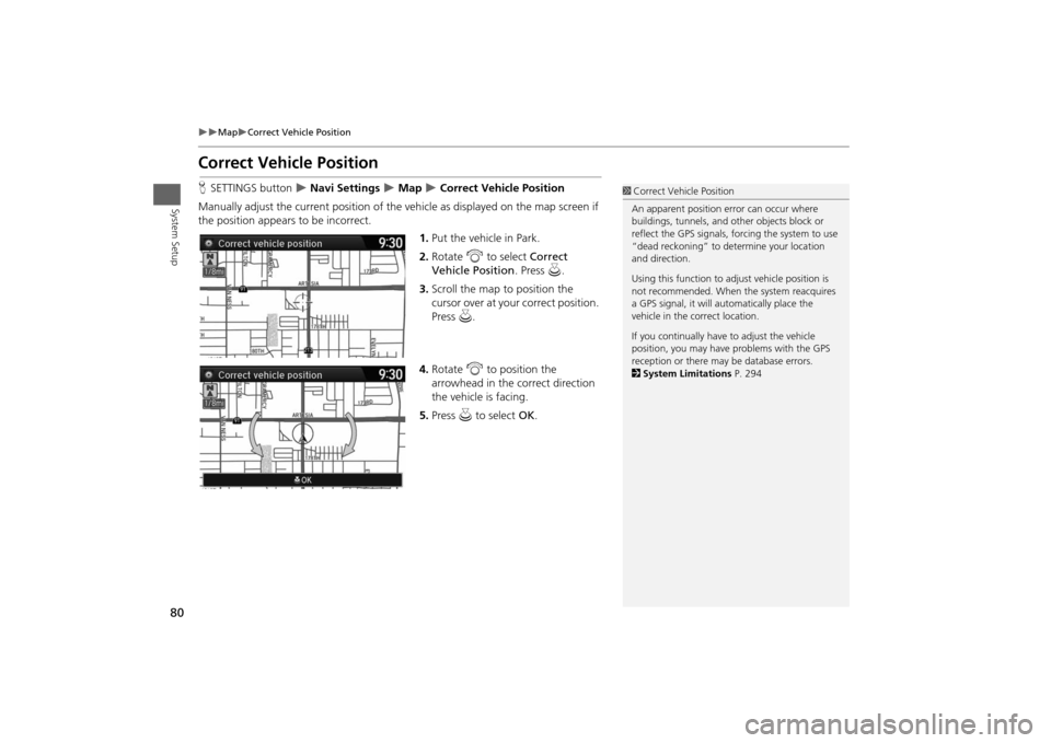
Manually adjust the current position of the vehicle as displayed on the map screen if
the position appears to be incorrect.
1.Put the vehicle in Park.
2.Rotate i to select Correct
Vehicle Position. Press u.
3.Scroll the map to position the
cursor over at your correct position.
Press u.
4.Rotate i to position the
arrowhead in the correct direction
the vehicle is facing.
5.Press u to select OK.
1Correct Vehicle Position
An apparent position error can occur where
buildings, tunnels, and other objects block or
reflect the GPS signals, forcing the system to use
“dead reckoning” to determine your location
and direction.
Using this function to adjust vehicle position is
not recommended. When the system reacquires
a GPS signal, it will automatically place the
vehicle in the correct location.
If you continually have to adjust the vehicle
position, you may have problems with the GPS
reception or there may be database errors.
2System Limitations P. 294
Page 83 of 327
82System Setup
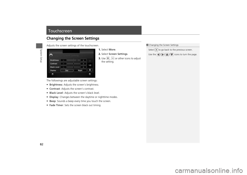
TouchscreenChanging the Screen SettingsAdjusts the screen settings of the touchscreen.
1.Select More.
2.Select Screen Settings.
3.Use N, B or other icons to adjust
the setting.
The followings are adjustable screen settings:
•Brightness: Adjusts the screen's brightness.
•Contrast: Adjusts the screen's contrast.
•Black Level: Adjusts the screen's black level.
•Display: Changes between the daytime or nighttime modes.
•Beep: Sounds a beep every time you touch the screen.
•Fade Timer: Sets the screen black out timing.
1Changing the Screen Settings
Select to go back to the previous screen.
Use the / / / icons to turn the page.
X
Page 84 of 327
83
Navigation
This section describes how to enter a destination, select a route to take,
and follow the route to your destination. It also describes how to change
your route or destination along the way.
Entering a Destination........................... 84
Address ................................................. 86
Address Book ......................................... 92
Previous Destination ............................... 93
Place Category ....................................... 94
Place Name ............................................ 96
Place Phone Number .............................. 99
ZAGAT................................................... 99
Download POI ...................................... 102
Scenic Route ........................................ 103
Intersection .......................................... 104
Map Input ............................................ 105
Coordinate .......................................... 107Calculating the Route............................108
Viewing the Routes ...............................109
Driving to Your Destination.................110
Viewing the Route ................................110
Listening to Voice Guidance ..................114
Reaching a Waypoint ............................115
Map Menu..............................................116
Displaying the Map Menu .....................116
Directions .............................................118
Traffic Rerouting™................................120
Changing Your Route............................122
Pausing the Route .................................123
Canceling the Route .............................123
Adding Waypoints ................................124Editing the Destination List ................... 128
Taking a Detour ................................... 130
Avoiding Streets ................................... 130
Changing Your Destination................. 131
Find Nearest Place ................................ 131
Selecting a Destination on the Map ...... 132
Entering a New Destination .................. 133
Resuming Your Trip.............................. 134
Page 85 of 327
84Navigation
Entering a DestinationHMENU button (on map)
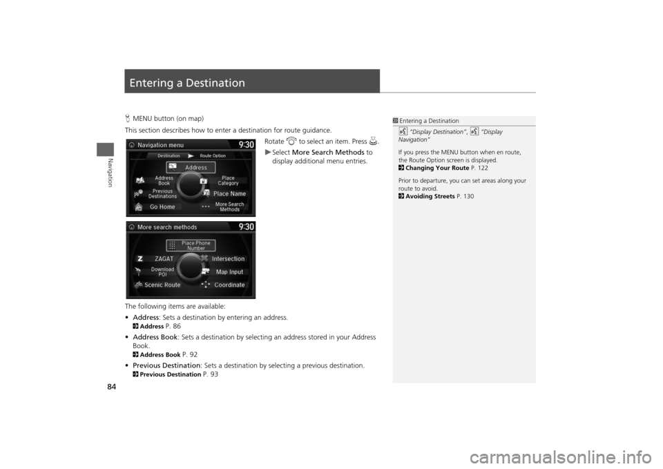
This section describes how to enter a destination for route guidance.
Rotate i to select an item. Press u.
Select More Search Methods to
display additional menu entries.
The following items are available:
•Address: Sets a destination by entering an address.
2Address
P. 86
•Address Book: Sets a destination by selecting an address stored in your Address
Book.
2Address Book
P. 92
•Previous Destination: Sets a destination by selecting a previous destination.
2Previous Destination
P. 93
1Entering a Destinationd
“Display Destination”,
d
“Display
Navigation”
If you press the MENU button when en route,
the Route Option screen is displayed.
2Changing Your Route P. 122
Prior to departure, you can set areas along your
route to avoid.
2Avoiding Streets P. 130
Page 87 of 327
86
Entering a Destination
Address
Navigation
AddressHMENU button
Address
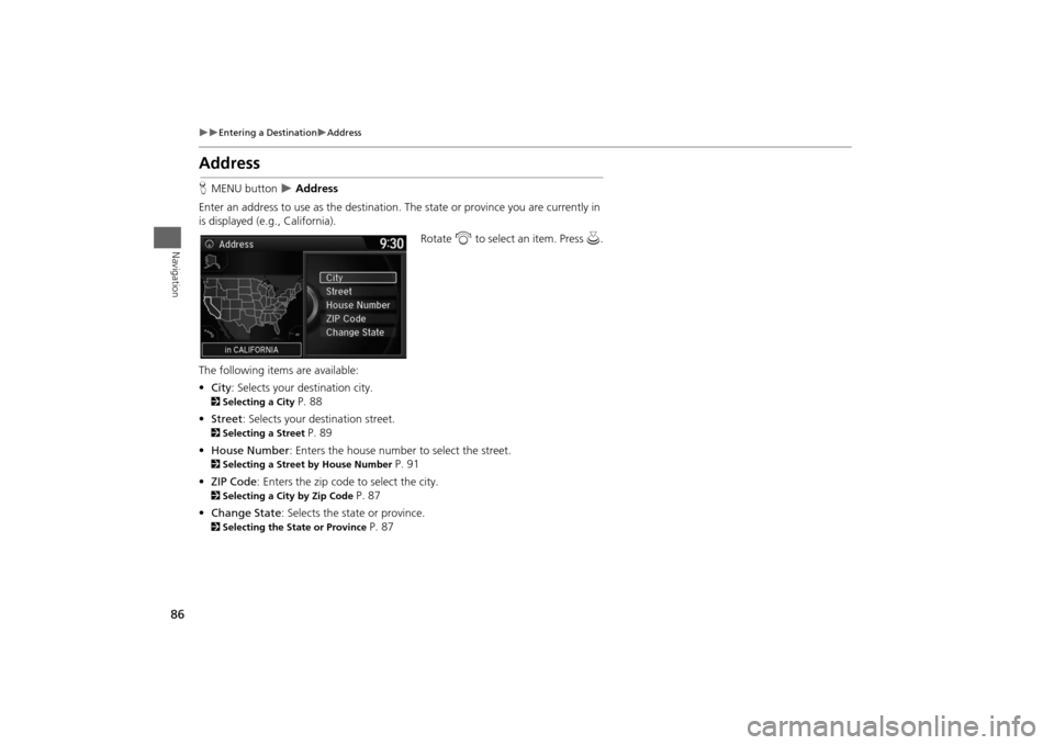
Enter an address to use as the destination. The state or province you are currently in
is displayed (e.g., California).
Rotate i to select an item. Press u.
The following items are available:
•City: Selects your destination city.
2Selecting a City
P. 88
•Street: Selects your destination street.
2Selecting a Street
P. 89
•House Number: Enters the house number to select the street.
2Selecting a Street by House Number
P. 91
•ZIP Code: Enters the zip code to select the city.
2Selecting a City by Zip Code
P. 87
•Change State: Selects the state or province.
2Selecting the State or Province
P. 87
Page 89 of 327
88
Entering a Destination
Address
Navigation
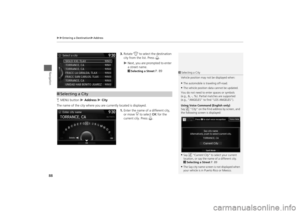
3.Rotate i to select the destination
city from the list. Press u.
Next, you are prompted to enter
a street name. 2Selecting a Street
P. 89
HMENU button
Address
City
The name of the city where you are currently located is displayed.
1.Enter the name of a different city,
or move r to select OK for the
current city. Press u.
■Selecting a City
1Selecting a City
Vehicle position may not be displayed when:•The automobile is traveling off-road.•The vehicle position data cannot be updated.
You do not need to enter spaces or symbols
(e.g., &, -, %). Partial matches are supported
(e.g., “ANGELES” to find “LOS ANGELES”).
Using Voice Command (English only)
Say d “City” on the Find address by screen, and
the following screen is displayed:•Say d “Current City” to select your current
location, or say the name of a different city.
2Selecting a Street P. 89•The Say city name screen is not displayed when
your vehicle is in Puerto Rico or Mexico.