display NISSAN PATHFINDER 2017 R52 / 4.G Navigation Manual
[x] Cancel search | Manufacturer: NISSAN, Model Year: 2017, Model line: PATHFINDER, Model: NISSAN PATHFINDER 2017 R52 / 4.GPages: 164, PDF Size: 0.78 MB
Page 19 of 164
![NISSAN PATHFINDER 2017 R52 / 4.G Navigation Manual SELECTING ITEM
When the item is touched, it is executed and the
next screen is displayed.
Touch [
] to return to the previous screen.
ADJUSTING VOLUME AND SET-
TINGS
Set the volume and brightness.
Tou NISSAN PATHFINDER 2017 R52 / 4.G Navigation Manual SELECTING ITEM
When the item is touched, it is executed and the
next screen is displayed.
Touch [
] to return to the previous screen.
ADJUSTING VOLUME AND SET-
TINGS
Set the volume and brightness.
Tou](/img/5/542/w960_542-18.png)
SELECTING ITEM
When the item is touched, it is executed and the
next screen is displayed.
Touch [
] to return to the previous screen.
ADJUSTING VOLUME AND SET-
TINGS
Set the volume and brightness.
Touch adjustment keys, such as [+]/[-], [L]/[R],
etc., to adjust each item. Each time a key is
touched, the indicator moves along the bar.
NAVIGATION SYSTEM STATUS
SCREEN
By pushing
the system can be displayed.
INFO:
There are different status screens displayed
depending on various factors, such as the
currently active mode, whether a destination
has been set or not, etc.
When a route to the destination is set and the
audio system is on, a screen similar to the one
above appears.
Touching [<]/[ >] can switch air conditioner
status screen, navigation route information
screen and fuel economy information screen.
When no route is set, a compass and the current
location is displayed instead of the route
information.
SHORTCUT MENU
Push
location map screen is displayed to display the
shortcut menu screen.
The items on the shortcut menu can be
customized to your preference.
Available items:
. Audio Source
. Audio List
. Call History
. Phonebook
. Cancel Route
. Nearby Places
. Store Location
. View Settings
2-7
2. Getting Started
Page 20 of 164
![NISSAN PATHFINDER 2017 R52 / 4.G Navigation Manual .Select Add/Edit
. (Blank)
EDIT SHORTCUT MENU
The following procedure can edit or sort the
shortcut menu.
1. Select [Select Add/Edit] to register a new
item to the menu, or to change an existing
menu NISSAN PATHFINDER 2017 R52 / 4.G Navigation Manual .Select Add/Edit
. (Blank)
EDIT SHORTCUT MENU
The following procedure can edit or sort the
shortcut menu.
1. Select [Select Add/Edit] to register a new
item to the menu, or to change an existing
menu](/img/5/542/w960_542-19.png)
.Select Add/Edit
. (Blank)
EDIT SHORTCUT MENU
The following procedure can edit or sort the
shortcut menu.
1. Select [Select Add/Edit] to register a new
item to the menu, or to change an existing
menu item.
2. Select preferred setting.
.[Change Order] Change the order in which shortcut menu
items are shown. Touch and hold the [
]
displayed next to the item you wish to
relocate. Drag the icon to the position in
the list where you wish to insert the item.
.[Edit Shortcut Items]
Edit items to be displayed in the shortcut
menu.
MAP MENU
While scrolling the map screen, push
or touch [] to display the Map Menu.
Available items:
. New Destination
. Show Current Location
. Store Location
. Nearby Places
. Delete Stored Location
DISPLAY VIEW BAR
Various map information screens can be shown
by selecting from the Display View Bar.
When the screen displays the map, push
Page 21 of 164

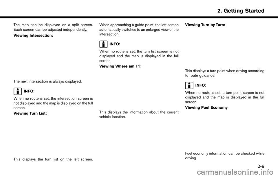
The map can be displayed on a split screen.
Each screen can be adjusted independently.
Viewing Intersection:
The next intersection is always displayed.
INFO:
When no route is set, the intersection screen is
not displayed and the map is displayed on the full
screen.
Viewing Turn List:
This displays the turn list on the left screen. When approaching a guide point, the left screen
automatically switches to an enlarged view of the
intersection.
INFO:
When no route is set, the turn list screen is not
displayed and the map is displayed in the full
screen.
Viewing Where am I ?:
This displays the information about the current
vehicle location. Viewing Turn by Turn:
This displays a turn point when driving according
to route guidance.
INFO:
When no route is set, a turn point screen is not
displayed and the map is displayed in the full
screen.
Viewing Fuel Economy
Fuel economy information can be checked while
driving.
2-9
2. Getting Started
Page 22 of 164

Viewing Eco Drive Report:
Your driving score will be displayed in real time,
with 100 points designated as the score for ideal
eco-driving.
For improving your score:. When starting off, depress the accelerator
gently.
. When cruising, accelerate and decelerate as
little as possible.
. When decelerating, releasing the accelera-
tor early.
CUSTOMIZING THE DISPLAY VIEW
BAR
The menu icons on the Display View Bar can be
customized to your preference.
1. Push
display the navigation setting screen. 2. Touch [Map & Display View] and touch
[Change Order].
3. Change the order of the icons to be displayed on the Display View Bar. Touch
and hold the [
] displayed next to the item
you wish to relocate. Drag the icon to the
position in the list where you wish to insert
the item.
HOW TO INPUT LETTERS AND
NUMBERS
CHARACTER (letters and numbers)
INPUT SCREEN
Alphanumeric characters are entered using the
keyboard screen.
*1Touch a character on the displayed key-
board. The selected character is entered.
*2Entered characters are displayed here.
*3Touch [Delete] to delete the last character
entered.
Touch and hold [Delete] to delete all the
characters entered.
2-10
2. Getting Started
Page 23 of 164
![NISSAN PATHFINDER 2017 R52 / 4.G Navigation Manual *4The symbol keys are displayed by touching
[Symbols]. The alphabet keys are displayed
by touching [A-Z].
*5Touch [Space] to enter a space.
*6Touch [OK] or [List] to finalize your input.
INFO:
. Touch NISSAN PATHFINDER 2017 R52 / 4.G Navigation Manual *4The symbol keys are displayed by touching
[Symbols]. The alphabet keys are displayed
by touching [A-Z].
*5Touch [Space] to enter a space.
*6Touch [OK] or [List] to finalize your input.
INFO:
. Touch](/img/5/542/w960_542-22.png)
*4The symbol keys are displayed by touching
[Symbols]. The alphabet keys are displayed
by touching [A-Z].
*5Touch [Space] to enter a space.
*6Touch [OK] or [List] to finalize your input.
INFO:
. Touch [CAPS] to toggle uppercase and
lowercase characters on the keyboard
screen.
. Touch [
]or[] to move the character
input position.
FUNCTIONS DISABLED WHILE
DRIVING
Example
2-11
2. Getting Started
Page 24 of 164

To help ensure safe driving, some functions
cannot be operated or have limited operation
while the vehicle is in motion.
The on-screen text and keys for these restricted
functions will be “grayed-out” or muted and
cannot be selected while driving. In some cases,
a screen message will appear indicating a
restricted function.
Restricted functions while driving include:. Character (letter and number) input screen.
. Scrolling and viewing of certain list screens
. Displaying detail information and touching
item on the information screen
. Adding/editing home location, address book
entries and current route
. Making a call by dial number and handset
phonebook
. Setting phone, NissanConnect
SMServices
and Bluetooth�Šfunctions
These functions will become available again
when the vehicle is not in motion.
Some of the destination setting functions that
become unavailable while driving can be oper-
ated by voice recognition system. Available voice
commands may differ depending on the lan-
guage setting.
2-12
2. Getting Started
Page 25 of 164

3 Map operation
Map types ........................................................................\
........... 3-22D map ........................................................................\
.......... 3-2
Birdview
TM(3D) map .......................................................... 3-3
Building graphics ................................................................. 3-4
Displaying current vehicle location ....................................... 3-4 Operating with control panel ............................................ 3-4
Operating with touch panel operation ........................... 3-4
Moving map ........................................................................\
........ 3-5 2D map ........................................................................\
.......... 3-5
Birdview
TM(3D) map .......................................................... 3-5
Changing scale of map ............................................................ 3-6
Touch panel operation ........................................................ 3-6 Multi-function controller operation ................................ 3-6
Map scale ........................................................................\
.... 3-6
Change map ........................................................................\
...... 3-7
Setting split screen .................................................................. 3-8
Map view settings .................................................................... 3-8
Setting information on map ................................................. 3-11 Displaying facility icons ................................................. 3-11
Displaying map scrolling information ......................... 3-11
Road color ....................................................................... 3-11
Traffic information on map ................................................... 3-12
Page 26 of 164

MAP TYPES
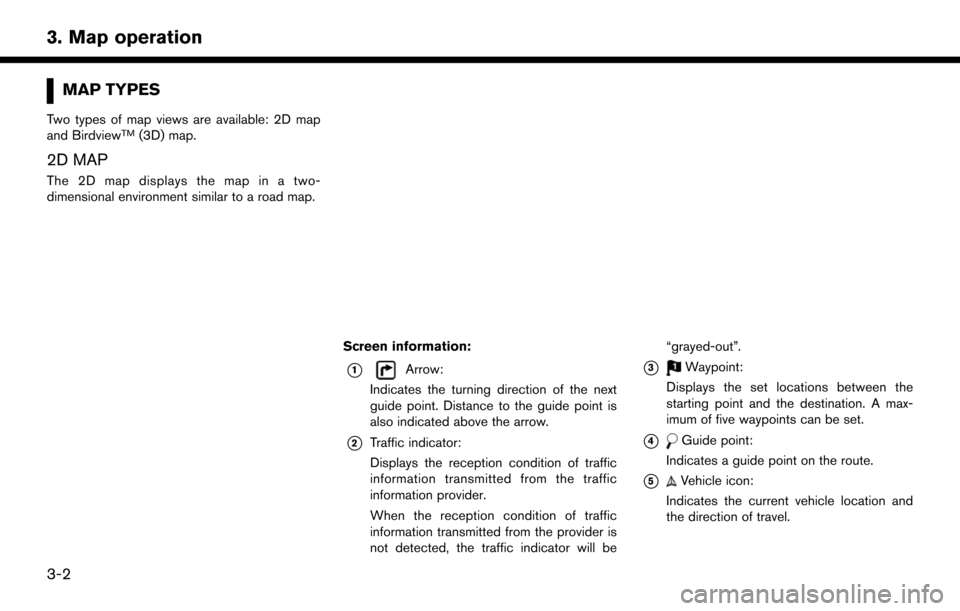
Two types of map views are available: 2D map
and BirdviewTM(3D) map.
2D MAP
The 2D map displays the map in a two-
dimensional environment similar to a road map.
Screen information:
*1Arrow:
Indicates the turning direction of the next
guide point. Distance to the guide point is
also indicated above the arrow.
*2Traffic indicator:
Displays the reception condition of traffic
information transmitted from the traffic
information provider.
When the reception condition of traffic
information transmitted from the provider is
not detected, the traffic indicator will be “grayed-out”.
*3Waypoint:
Displays the set locations between the
starting point and the destination. A max-
imum of five waypoints can be set.
*4Guide point:
Indicates a guide point on the route.
*5Vehicle icon:
Indicates the current vehicle location and
the direction of travel.
3-2
3. Map operation
Page 27 of 164

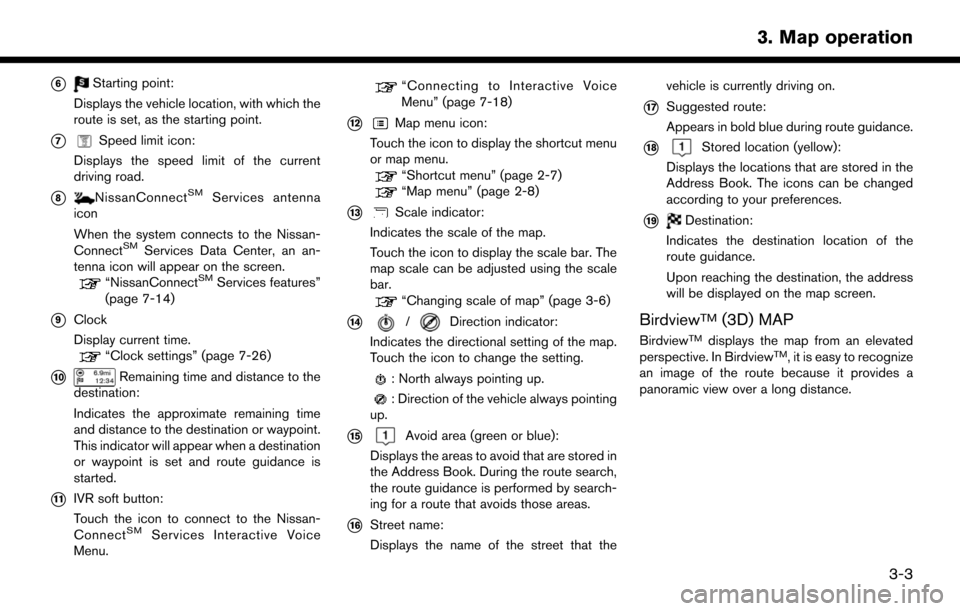
*6Starting point:
Displays the vehicle location, with which the
route is set, as the starting point.
*7Speed limit icon:
Displays the speed limit of the current
driving road.
*8NissanConnectSMServices antenna
icon
When the system connects to the Nissan-
Connect
SMServices Data Center, an an-
tenna icon will appear on the screen.
“NissanConnectSMServices features”
(page 7-14)
*9Clock
Display current time.
“Clock settings” (page 7-26)
*10Remaining time and distance to the
destination:
Indicates the approximate remaining time
and distance to the destination or waypoint.
This indicator will appear when a destination
or waypoint is set and route guidance is
started.
*11IVR soft button:
Touch the icon to connect to the Nissan-
Connect
SMServices Interactive Voice
Menu.
“Connecting to Interactive Voice
Menu” (page 7-18)
*12Map menu icon:
Touch the icon to display the shortcut menu
or map menu.
“Shortcut menu” (page 2-7)“Map menu” (page 2-8)
*13Scale indicator:
Indicates the scale of the map.
Touch the icon to display the scale bar. The
map scale can be adjusted using the scale
bar.
“Changing scale of map” (page 3-6)
*14/Direction indicator:
Indicates the directional setting of the map.
Touch the icon to change the setting.
: North always pointing up.
: Direction of the vehicle always pointing
up.
*15Avoid area (green or blue):
Displays the areas to avoid that are stored in
the Address Book. During the route search,
the route guidance is performed by search-
ing for a route that avoids those areas.
*16Street name:
Displays the name of the street that the vehicle is currently driving on.
*17Suggested route:
Appears in bold blue during route guidance.
*18Stored location (yellow):
Displays the locations that are stored in the
Address Book. The icons can be changed
according to your preferences.
*19Destination:
Indicates the destination location of the
route guidance.
Upon reaching the destination, the address
will be displayed on the map screen.
BirdviewTM(3D) MAP
BirdviewTMdisplays the map from an elevated
perspective. In BirdviewTM, it is easy to recognize
an image of the route because it provides a
panoramic view over a long distance.
3-3
3. Map operation
Page 28 of 164

INFO:
Note the following items about the Birdview
TM
display. . “BirdviewTM” is a registered trademark of
Clarion Co., Ltd.
. The map in Birdview
TMalways appears with
the current forward direction facing up.
BUILDING GRAPHICS
In an area where the building graphics are stored
in the map data, the building graphics are
displayed when the map is zoomed in. On the
2D map display, these are called “Building
footprint graphics”, and on the Birdview
TMdis-
play, these are called “3D building graphics”.
The way of looking at the map is the same for the
2D and Birdview
TMmaps.
Building footprint graphics (2D map)
3D building graphics (BirdviewTMmap)
INFO:
In an area where the building graphics are not
stored in the map data, the normal map is
displayed even when the map is zoomed in.
DISPLAYING CURRENT VEHICLE
LOCATION
OPERATING WITH CONTROL PA-
NEL
The basic map screen displays the current
location (the position where the vehicle mark is
located) . Push