SUBARU LEGACY 2012 5.G Navigation Manual
Manufacturer: SUBARU, Model Year: 2012, Model line: LEGACY, Model: SUBARU LEGACY 2012 5.GPages: 90, PDF Size: 1.82 MB
Page 81 of 90
Navigation 95
Other Functions
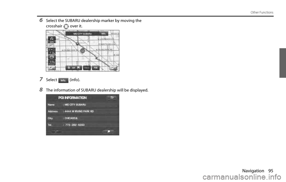
6Select the SUBARU dealership marker by moving the
crosshair over it.
7Select (info).
8The information of SUBARU dealership will be displayed.
Page 82 of 90
96 Navigation
Version and Initialization
Version
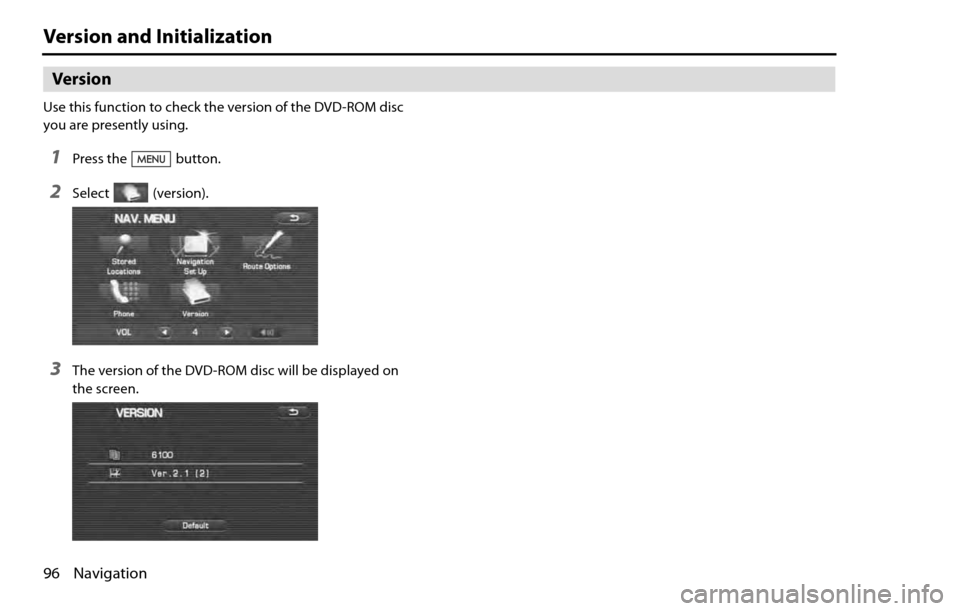
Use this function to check the version of the DVD-ROM disc
you are presently using.
1Press the button.
2Select (version).
3The version of the DVD-ROM disc will be displayed on
the screen.
Page 83 of 90
Navigation 97
Version and Initialization
Initialization of the navigation settings
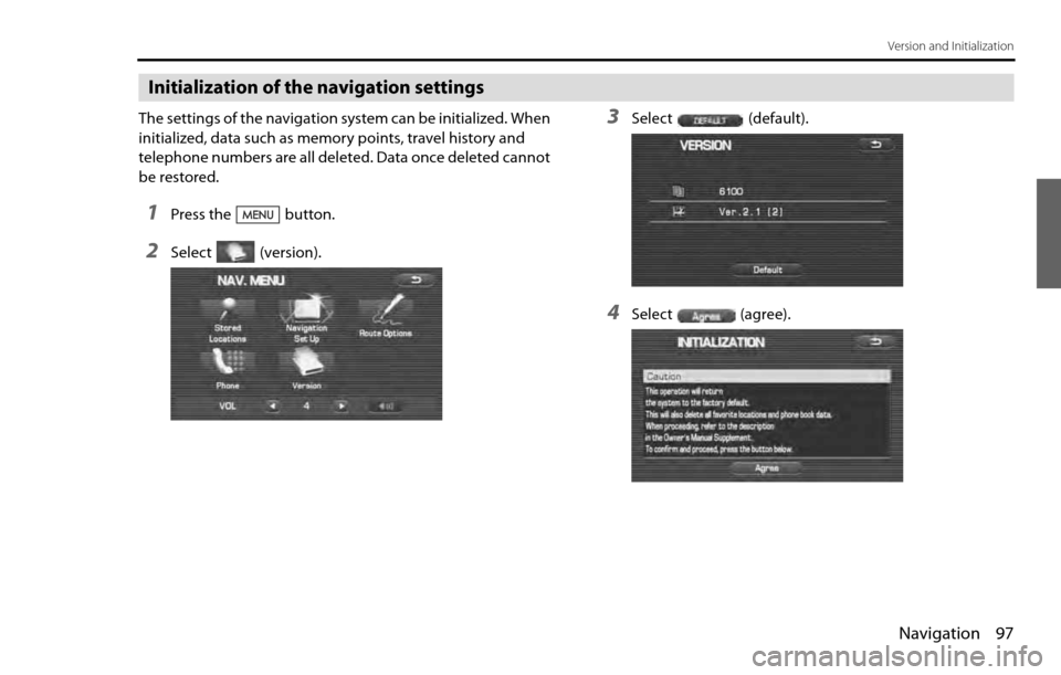
The settings of the navigation system can be initialized. When
initialized, data such as memory points, travel history and
telephone numbers are all deleted. Data once deleted cannot
be restored.
1Press the button.
2Select (version).
3Select (default).
4Select (agree).
Page 84 of 90
98 Navigation
Version and Initialization
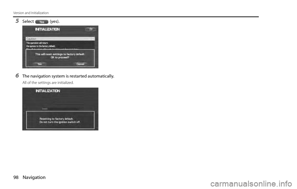
5Select (yes).
6The navigation system is restarted automatically.
All of the settings are initialized.
Page 85 of 90

Navigation 99
General Information
■Accuracy of vehicle position
Area in which GPS signals cannot be received
Because the radiowave signals from the GPS satellites travel primarily
by line of sight, the navigation system might not be able to receive
the signals in the areas described below.(If the GPS mark does not
appear on the map screen, it means that the GPS radiowave signals
are not being properly received.)
(1) Inside a tunnel
(2) Inside a building
(3) Under a three-dimensional road system such as for high speed
roads
(4) On boulevards lined with trees
(5) Between buildings
(6) Under a cliff or in a cave
•If the GPS antenna or its surroundings are blocked by an obstacle
(including cargo), it might not be possible for the system to
receive the GPS radiowave signals.
•If multiple paths are created due to the reflection from buildings,
a large measurement error could occur, causing the vehicle's
mark to deviate from its actual position.
Deviation of the vehicle's position mark
The vehicle's position mark could deviate from its actual position
when the vehicle is being driven under the conditions listed below or
due to conditions of the GPS satellites.
If the vehicle travels on a road whose actual shape differs from that in
the map data, the vehicle's mark could deviate from the actual posi-tion. The correct position will eventually appear on the screen
through the correction function. If the screen does not show the cor-
rect position for an excessively long time, correct the current position
or make an automatic correction.
(1) The vehicle's mark could appear on a parallel road.
(2) When the road splits into a narrow Y, the vehicle's mark could
appear on the other fork of the Y.
(3) When the vehicle makes a right or left turn, the vehicle's mark
could appear on one street ahead or behind.
(4) If the vehicle is transported by means other than the vehicle's
own power, such as on a ferryboat, the vehicle's mark will
remain in the position it was before the transport until the sys-
tem can calculate the position through the GPS.
(5) When the vehicle is driven on a steep incline, the vehicle's mark
could deviate from its actual position.
(6) If there are continuous gradual curves in the same direction, the
vehicle's mark could deviate from its actual position.
(7) If the vehicle is driven in a zigzag pattern, such as through fre-
quent lane changes, the vehicle's mark could deviate from its
actual position.
(8) If the vehicle is placed on a turntable, such as in a parking area,
and turned with the ignition OFF, the vehicle's mark could devi-
ate from its actual orientation. The vehicle's mark could also
deviate even after the vehicle has exited the parking area.
(9) The vehicle's mark could deviate from its actual position if the
vehicle is driven using tire chains or snow tires on a snow-cov-
ered road or on a mountainous road.
Page 86 of 90

100 Navigation
General Information
(10) The vehicle's mark could deviate from its actual position after
the tires have been replaced.
(11) While driving on a public road, if an expressway that is under
construction travels over the public road, the position mark of
the vehicle may be indicated on a different road.
(12) If other electronic devices are installed on the instrument panel,
these devices may adversely affect the GPS signal communica-
tion and the position of the vehicle may not be indicated cor-
rectly.
■How the vehicle position is detected
Detecting the vehicle's position through the GPS
GPS stands for "Global Positioning System", which is a system used for
detecting an object's position through the use of satellites of the U.S.
Department of Defense.
Radiowave signals from three or more satellites are received by the
navigation system, which utilizes the principle of triangulation to
detect the position at which the radiowave signals are received.
When the navigation unit is receiving the GPS radiowave signals, a
"GPS" mark will appear on the map screen.
Detecting the vehicle's position through self-contained naviga-
tion
Self-contained navigation is a system that detects the vehicle's posi-
tion by calculating the vehicle's driven distance and turning angle
though the use of various types of sensors that are mounted on the
vehicle.Through the use of self-contained navigation, the vehicle's position
can be detected even in an area where the GPS radiowave signals
cannot be received.
Making corrections to the detection of the vehicle's position
through map matching
•In map matching, the position information resulting from the
detection of the vehicle's position and the locus of the travel of
the vehicle up to the present are constantly compared to the
shape of the roads on the map in order to correct the vehicle's
position mark to the most appropriate road.
•If the vehicle is driven on a road whose actual shape differs from
its map data, the vehicle's position mark on the map could devi-
ate from its actual position.
Occasionally, the correction of the vehicle's position mark to the
actual road on the map can be observed, particularly after the
vehicle has turned at an intersection or has exited from a parking
area.
■Accuracy of the route guidance
The conditions listed below do not indicate a malfunction.
(1) The guidance might prompt the driver to drive straight even
though the vehicle is being driven on a straight road.
(2) The directional guidance could display multiple place names.
(3) If the vehicle makes a turn at an intersection before the guided
route, the wrong type of voice guidance could be outputted.
(4) The guidance might not be outputted while the vehicle is mak-
ing a turn at an intersection.
(5) The system might not be able to search for the proper route.
Page 87 of 90

Navigation 101
General Information
(6) If there is no road to the destination or if there is only a narrow
road, the route might be indicated up to an area that is short of
the destination.
(7) The repeat search could take a long time while the vehicle is
being driven at high speeds.
(8) While the system is searching again for the route, the route indi-
cation might not appear in time for the next right or left turn.
(9) The route might not change even if a search is made again.
(10) The system might guide the driver to make a U-turn.
(11) The system might guide the driver to a road that cannot actu-
ally be travelled (such as a road to which entry is prohibited).
(12) The system might not output guidance even if the vehicle is
driven in reverse on the guided route.
(13) The system might not use a local ferryboat even if the ferry pri-
ority is selected.
(14) If the intersection that you're being guided to is near the end of
the route search, the system might not be able to provide guid-
ance.
(15) The route might not go on a toll road even if the toll-road prior-
ity is selected.
Similarly, a route that uses a toll road could appear on the
screen even if the toll-road priority is not selected. ( The driver
may or may not be able to select "toll-road priority" if both toll
and free roads are available.)
Page 88 of 90
102 Navigation
General Information
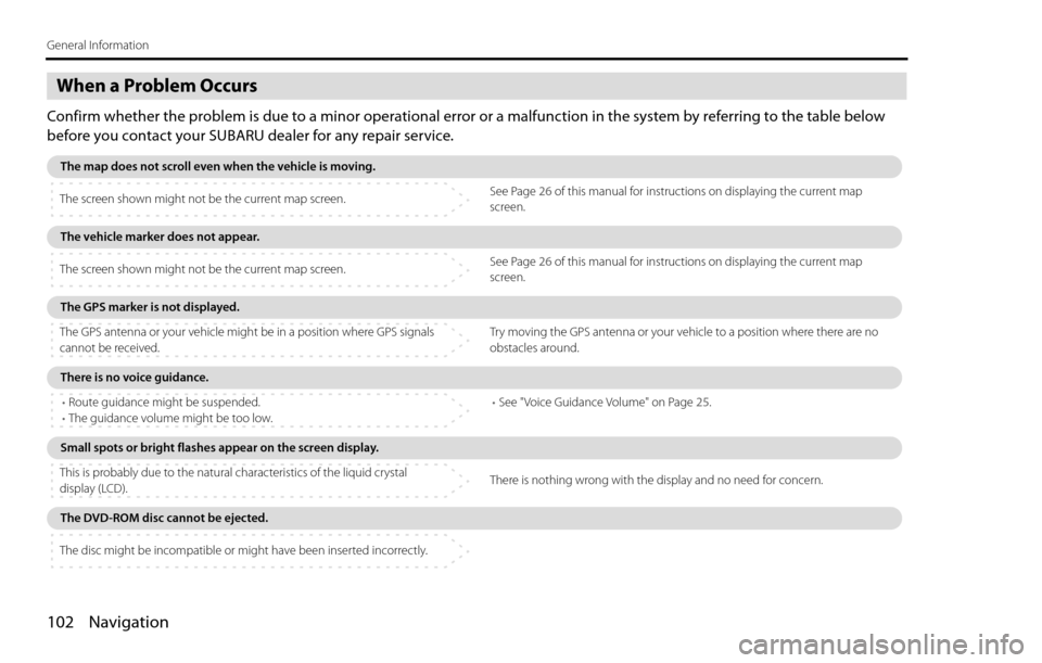
When a Problem Occurs
Confirm whether the problem is due to a minor operational error or a malfunction in the system by referring to the table below
before you contact your SUBARU dealer for any repair service.
The map does not scroll even when the vehicle is moving.
The screen shown might not be the current map screen.See Page 26 of this manual for instructions on displaying the current map
screen.
The vehicle marker does not appear.
The screen shown might not be the current map screen.See Page 26 of this manual for instructions on displaying the current map
screen.
The GPS marker is not displayed.
The GPS antenna or your vehicle might be in a position where GPS signals
cannot be received.Try moving the GPS antenna or your vehicle to a position where there are no
obstacles around.
There is no voice guidance.
•Route guidance might be suspended.
•The guidance volume might be too low.•See "Voice Guidance Volume" on Page 25.
Small spots or bright flashes appear on the screen display.
This is probably due to the natural characteristics of the liquid crystal
display (LCD).There is nothing wrong with the display and no need for concern.
The DVD-ROM disc cannot be ejected.
The disc might be incompatible or might have been inserted incorrectly.
Page 89 of 90
Navigation 103
Voice activation system
The voice recognition function allows you to operate the navigation
system, audio system and hands-free phone system using your voice
instead of display screen handling. This section includes instructions
about how to perform the voice commands. The commands that can
be recognized by this system are restricted. (See Page 222.) For each
function, refer to the corresponding items.
■Correct voice recognition
The interior circumstances of the vehicle will adversely affect the cor-
rect recognition of the voice. Note the following items in order for the
system to correctly recognize the voice.
•Speak clearly into the microphone. Speaking faster or slower and
pausing between words will cause incorrect recognition.
•Close the windows to eliminate outside noise. Traffic noises, driv-
ing sounds and wind noises may affect correct recognition of the
voice.
•Speak the voice commands correctly. The commands that can be
recognized by this system are restricted. Any terms other than
the recognized terms for the system or dull sounds that are incor-
rectly spoken will not be recognized by the system. If the name
of a facility is pronounced different from the recognized terms for
the system, the command will not be recognized by the system.
•The microphone is located at the best distance and in the best
direction for each model to gain the maximum voice recognition
performance. Speak commands in a correct driving posture.
•Do not speak commands during navigation voice guidance. This
causes sounds to overlap and results in incorrect voice recogni-
tion.
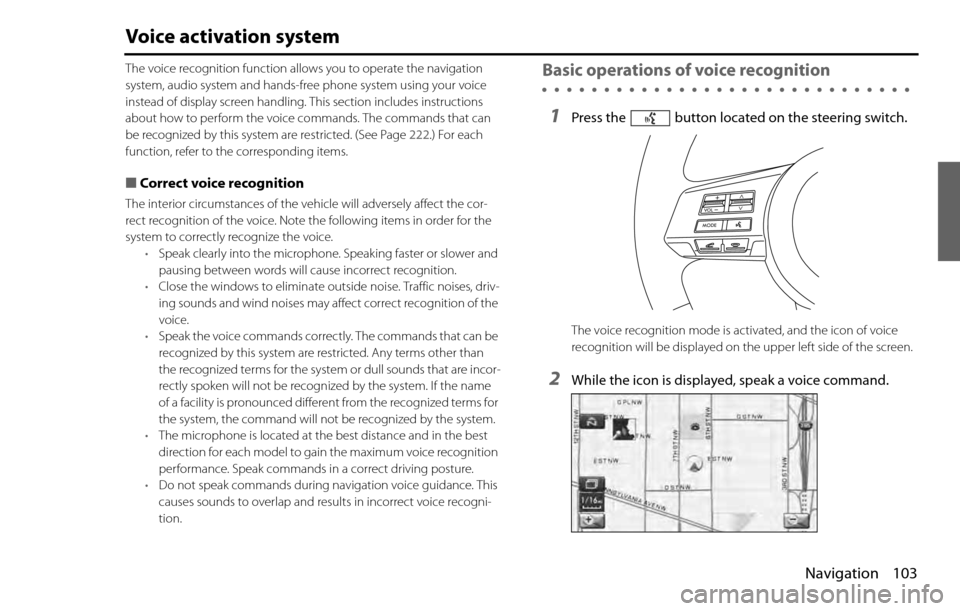
Basic operations of voice recognition
1Press the button located on the steering switch.
The voice recognition mode is activated, and the icon of voice
recognition will be displayed on the upper left side of the screen.
2While the icon is displayed, speak a voice command.
Page 90 of 90

104 Navigation
Voice activation system
During the voice recognition mode, the sound from the audio sys-
tem is muted.
(voice input waiting mode):
shows the status of waiting for a voice command.
(during a calculation):
shows the status of accepting and processing a voice command.
After a voice command is spoken, the system recognizes the voice and
activates the function input by the voice command. Then the system
confirms your command by voice guidance.
Pressing the button located on the steering wheel for a long
time during voice recognition will cancel the voice recognition mode.