navigation TOYOTA COROLLA iM 2018 Accessories, Audio & Navigation (in English)
[x] Cancel search | Manufacturer: TOYOTA, Model Year: 2018, Model line: COROLLA iM, Model: TOYOTA COROLLA iM 2018Pages: 164, PDF Size: 8.51 MB
Page 109 of 164
1. BASIC INFORMATION BEFORE OPERATION
1. QUICK REFERENCE
1. BASIC INFORMATION BEFORE OPERATION
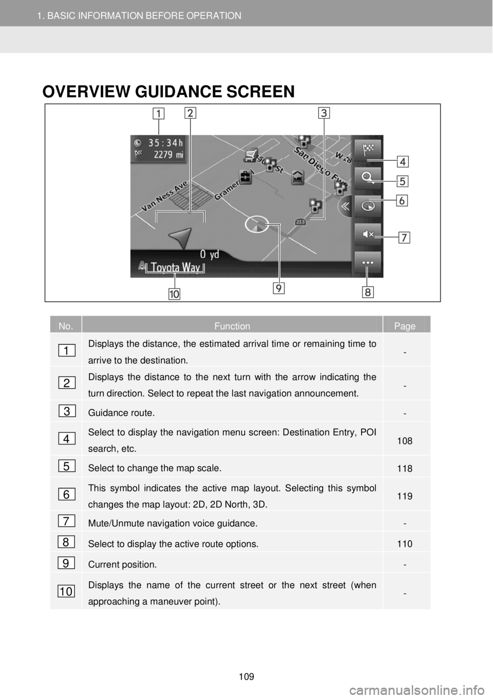
OVERVIEW GUID ANCE SCREEN
No. Function Page
Displays the distance, the estimated arrival time or remaining time to
arrive to the destination. -
Displays the distance to the next turn with the arrow indicating the
turn direction. Select to repeat the last navigation announcement. -
Guidance route. -
Select to display the navigation menu screen: Destination Entry, POI
search, etc. 108
Select to change the map scale. 118
This symbol indicates the active map layout. Selecting this symbol
changes the map layout: 2D, 2D North, 3D. 119
Mute/Unmute navigation voice guidance. -
Select to display the active route options. 110
Current position. -
Displays the name of the current street or the next street (when
approaching a maneuver point). -
1
2
3
4
5
6
7
8
9
10
109
Page 112 of 164
1. BASIC INFORMATION BEFORE OPERATION 1. BASIC INFORMATION BEFORE OPERATION
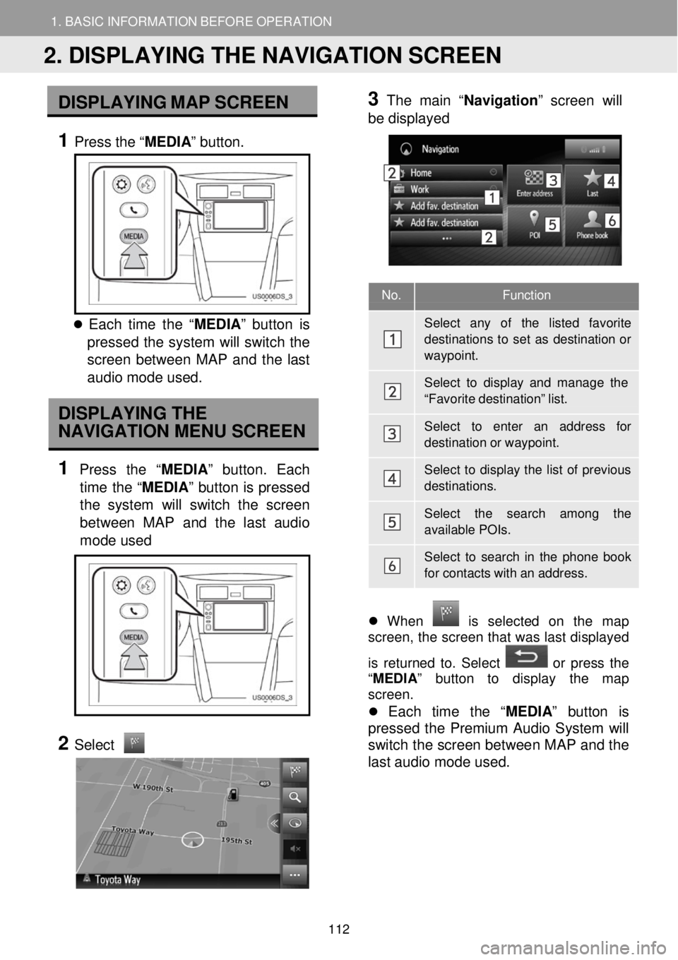
No. Functi on
Sele ct any of the listed favorite destinations to set as destination o r
waypoint.
Sele ct to display and mana ge the
“Favo rite destination” list.
Sele ct to enter an address for
destination or waypoint.
Select to display the list of previous
destinations.
Sele ct the search among the
available POIs.
Select to sear ch in the phone book
for contacts with an addr ess.
DISPLAY ING MAP SCR EEN
1 Press the “ MEDIA” button.
Each time t he “ MEDIA ” button is
pressed th e system will switch the
scre en between MAP and the last
au dio mod e used.
DISPLAYING THE
NAVIGATION MENU SCREEN
1 Press the “MEDIA” butt on. Each
time the “MEDIA ” button is pressed
the system w ill switch the scr een
betw een MAP and the last audi o
mo de used
2
Select
3 Th
e main “ Navigatio n” screen will
b e displa yed
Wh en is selected on the map
screen, the screen t hat was las t displ ayed
is returne d to. Se lect
or p ress t he
“ MEDIA ” button to displa y th e map
screen.
Each time the “ MEDIA” button is
pr esse d the Premium Audio System w ill
switch t he screen between MAP and the
last audio mode us ed.
2. DISPLAYING THE NAVIGATION SCREEN
112
Page 113 of 164
1. BASIC INFORMATION BEFORE OPERATION 1. BASIC INFORMATION BEFORE OPERATION
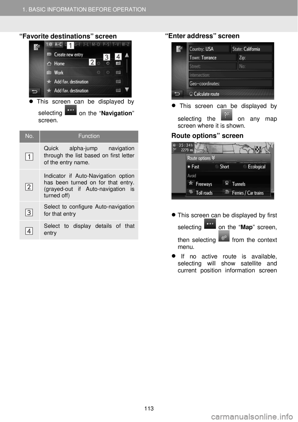
No. Functi on
Quick alpha-jump navigation
through the list based on first letter of the entry name.
Indicator if Auto-Navigation option has been turned on for that entry. (grayed -out if Auto-navigation is turned off)
Select to configure Auto-navigation for that entry
Select to display details of that entry
“Favorite destinations” screen
This screen can be displ ayed by
se lecting
on the “ Navigation ”
screen.
“Enter address” screen
This screen can be displayed by
selecting the
on any map
screen where it is shown.
Route options” screen
This screen can be displayed by first
selecting
on the “ Map” screen,
then selecting
f rom the context
menu.
If no active route is available,
selecting will show satellite and
current position information screen
113
Page 114 of 164
1. BASIC INFORMATION BEFORE OPERATION
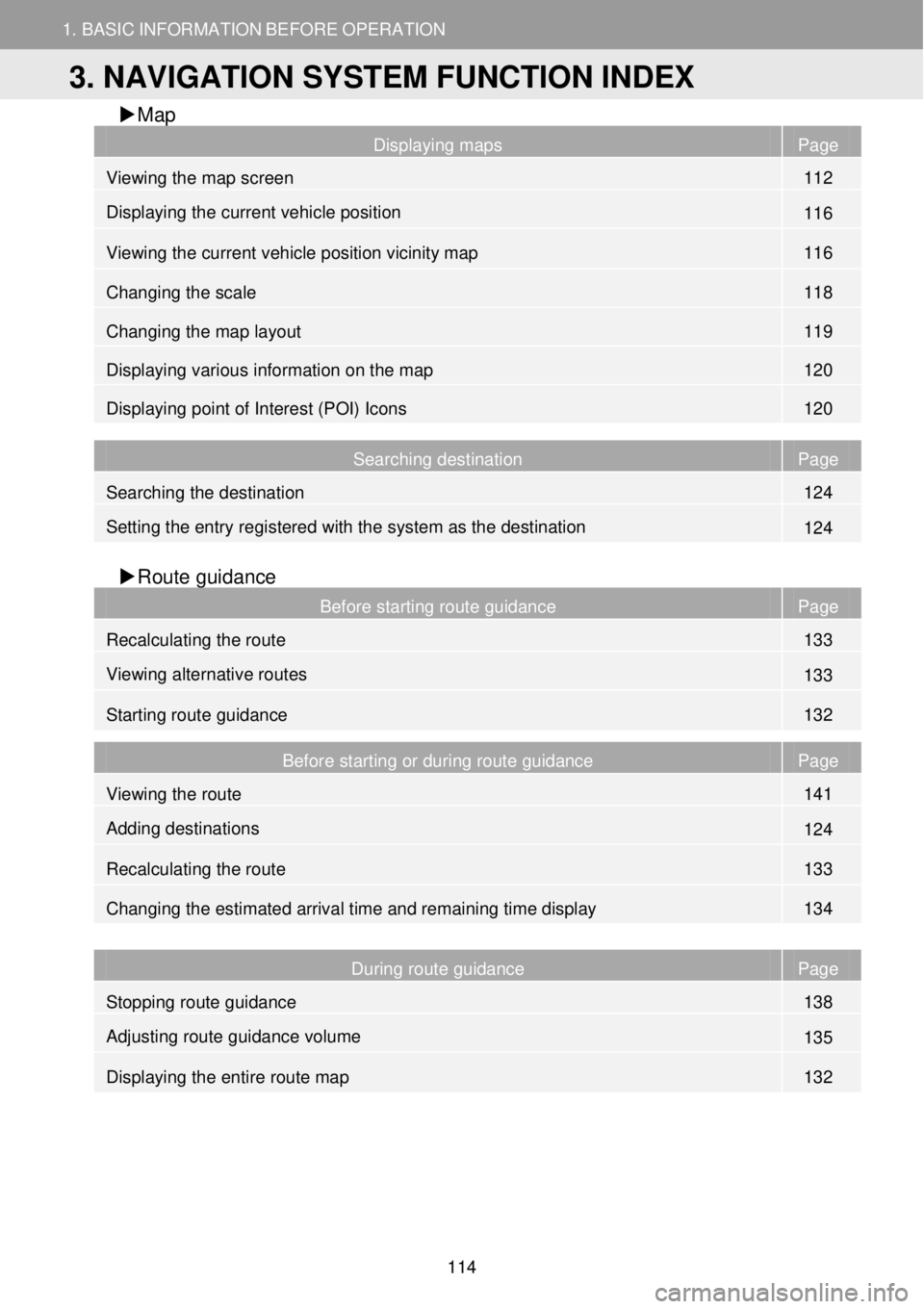
3. NAVIGATION SYSTEM FUNCTION INDEX
1. BASIC INFORMATION BEFORE OPERATION
Map
Displaying maps Page
Viewing the map screen 112
Displaying the current vehicle position 116
Viewing the current vehicle position vicinity map 116
Changing the scale 118
Changing the map layout 119
Displaying various information on the map 120
Displaying point of Interest (POI) Icons 120
Searching destination Page
Searching the destination 124
Setting the entry registered with the system as the destination 124
Route gui dance
Before starting route guidance Page
Recalculating the route 133
Viewing alternative routes 133
Starting route guidance 132
Before starting or during route guidance Page
Viewing the route 141
Adding destinations 124
Recalculating the route 133
Changing the estimated arrival time and remaining time display 134
During route guidance Page
Stopping route guidance 138
Adjusting route guidance volume 135
Displaying the entire route map 132
3. NAVIGATION SYSTEM FUNCTION INDEX
114
Page 115 of 164
1. BASIC INFORMATION BEFORE OPERATION
3. NAVIGATION SYSTEM FUNCTION INDEX
1. BASIC INFORMATION BEFORE OPERATION
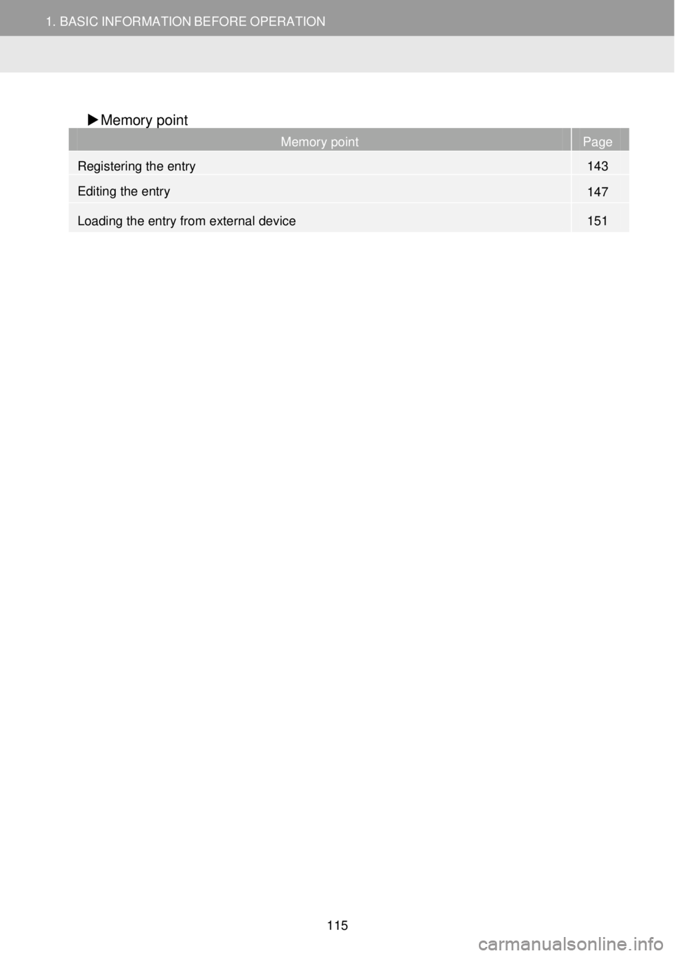
Memory point
Memory point Page
Registering the entry 143
Editing the entry 147
Loading the entry from external device 151
115
Page 116 of 164
2.MAPSCREENOPERATIONANDMAPICONS
1.MAPSCREENOPERATION
2.MAPSCREENOPERATIONANDMAP
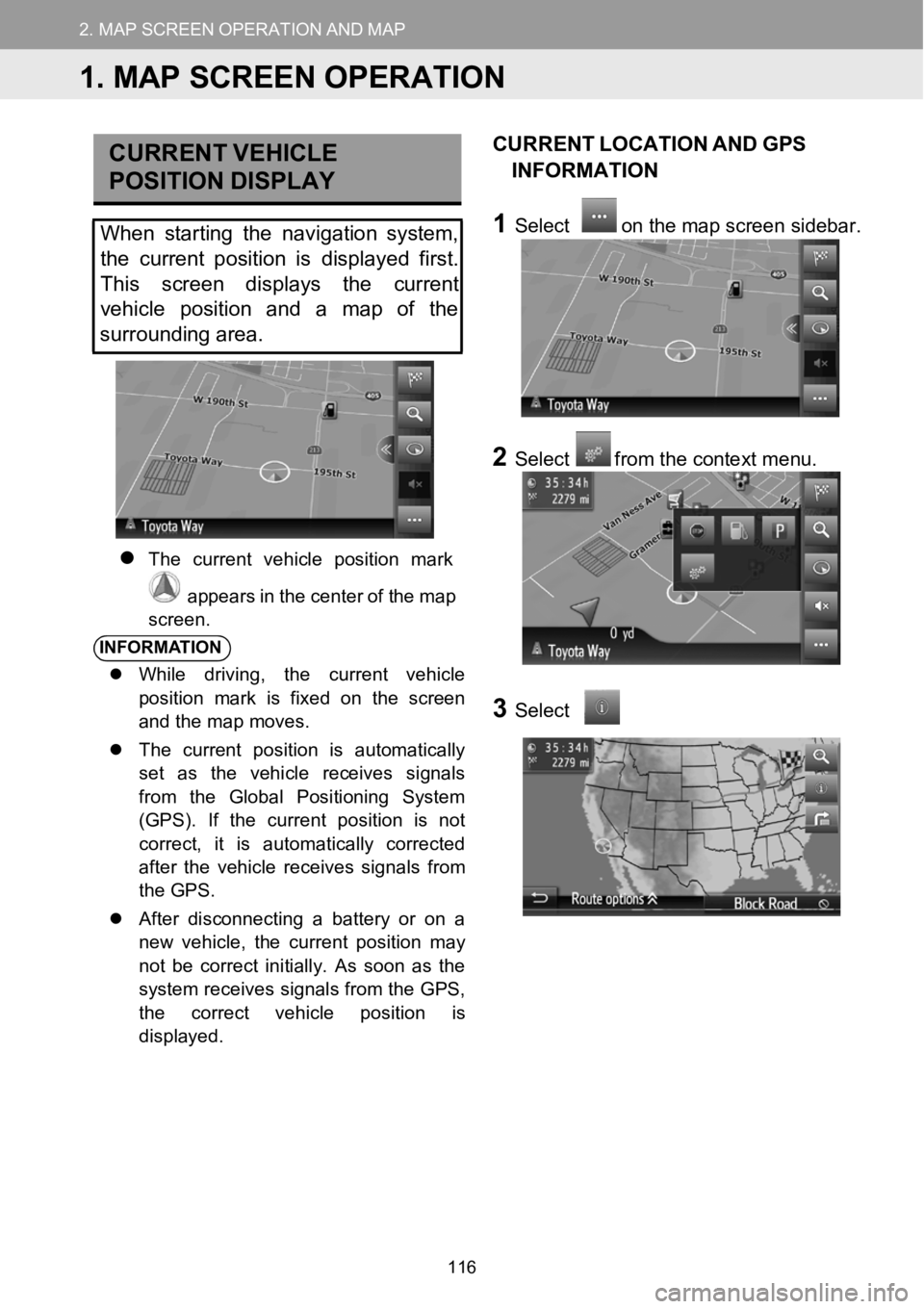
CURRE NT VEHICLE
P OSITION DISPLAY
When starting the navigation system,
the curre nt position isdisplayed first.
This screen displays the current
vehi cle position and amap of the
surrounding area.
The current vehicle po sition mark
appears in the center o f themap
scree n.
INFORMA TION
While driving, the current vehicle
position mark is fixed on the screen
and the map moves.
The current position is automatically
set as the vehicle receives signals
from the Global Positioning System
(GPS). If the current position is not
correct, it is automatically corrected
after the vehicle receives signals from
the GPS.
After disconnecting a battery or on a
new vehicle, the current position may
not be correct initially. As soon as the
system receives signals from the GPS,
the correct vehicleposition is
displayed.
CU RRENT LOCATION ANDGPS
INFORMATI ON
1Select on the map screen s idebar.
2Selectfrom the context menu.
3Select
1.MAP SCREEN OPERATION
116
Page 121 of 164
2.MAPSCREENOPERATIONANDMAPICONS2.MAPSCREENOPERATIONANDMAPICONS
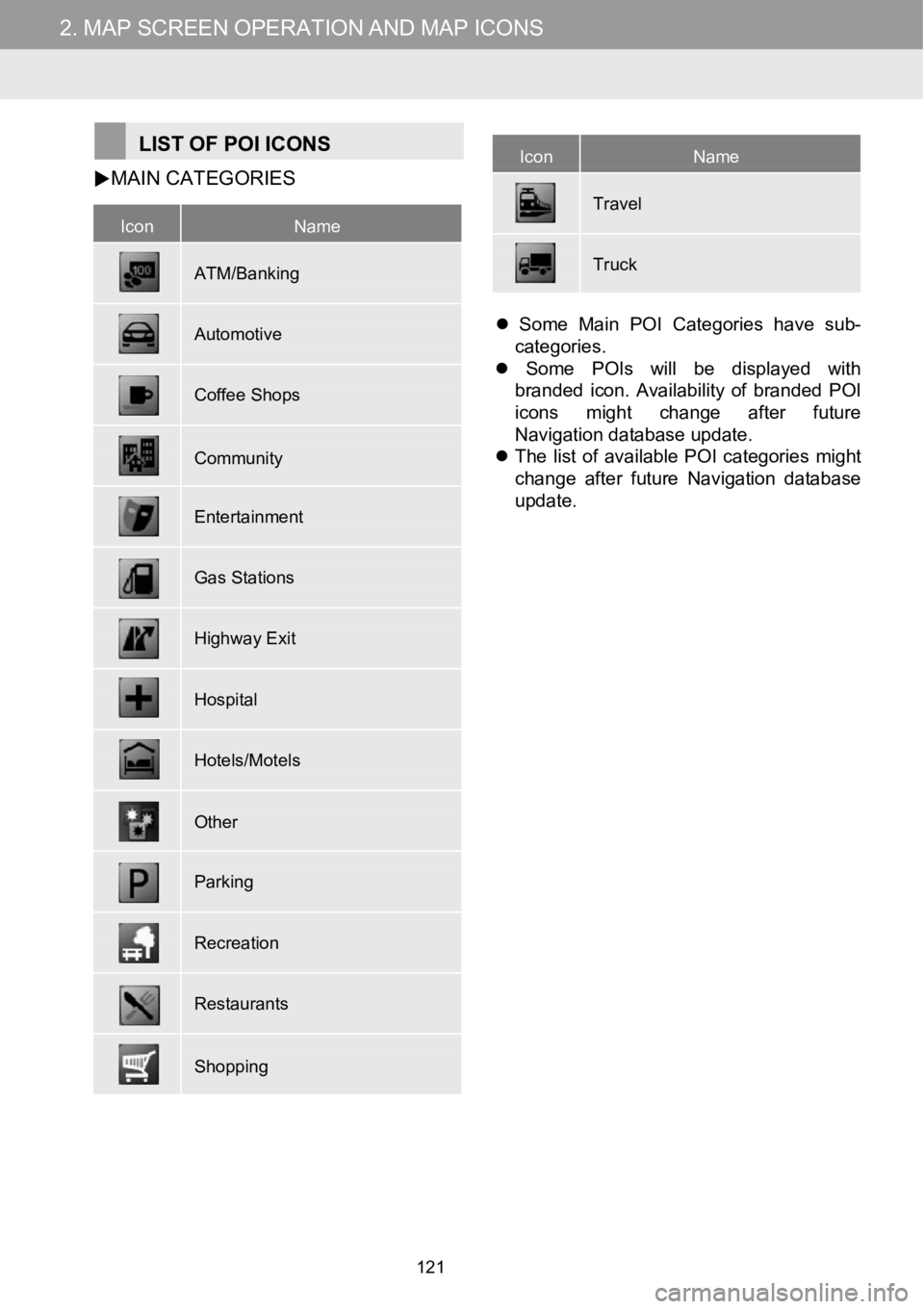
IconName
ATM/Banking
Automotive
Coffee Shops
Community
Entertainment
Gas Stations
Highway Exit
Hospital
Hotels/Motels
Other
Parking
Recreation
Restaurants
Shopping
IconName
Tra vel
Truck
LIST OFPOI ICONS
MAIN
CATEGORIES
Some Main POI Categories have sub-
categories.
Some POIs will be displayed with
branded icon. Availability of branded POI
icons might change after future
Nav igation database update.
The list of available POI categories might
change after future Navigation database
update.
121
Page 130 of 164
3.DESTINATIONSEARCH3.DESTINATIONSEARCH
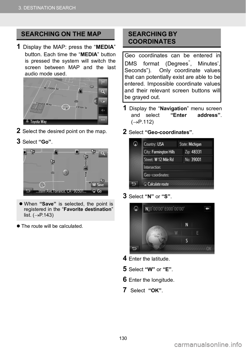
SEARCHING ONTHEMAP
1Display theMAP: press the “ME DIA ”
button.
Each time the“MEDIA ”button
is pressed the system will switch the
screen between MAP a nd the last
audio mode us ed.
2Select the desired p oint on t he m ap.
3Select “Go”.
Whe n“Save ”is sel ect ed, the po intis
re gis tere d in the “ Favori tedesti nation ”
list. ( →P.143)
The rou tewill be c alcula ted.
SEAR CHING BY
COORDI NATES
Geocoordinates can be enteredin
DMS f ormat (Degrees
°,Minutes’,
Sec onds”). Only coordinate values
tha t can potentially exist areable tobe
entered. Impossible coordinate values
and their relevant screen buttonswill
be grayed out.
1Disp lay the “Navigation ” me nu screen
and select “Enteraddress”.
(→P.112)
2Select “Geo-coordinate s”.
3Select “N”or “S”.
4Enter the latitude.
5Select “W”or “E”.
6Enter t he long itude.
7Select “OK”.
130
Page 134 of 164
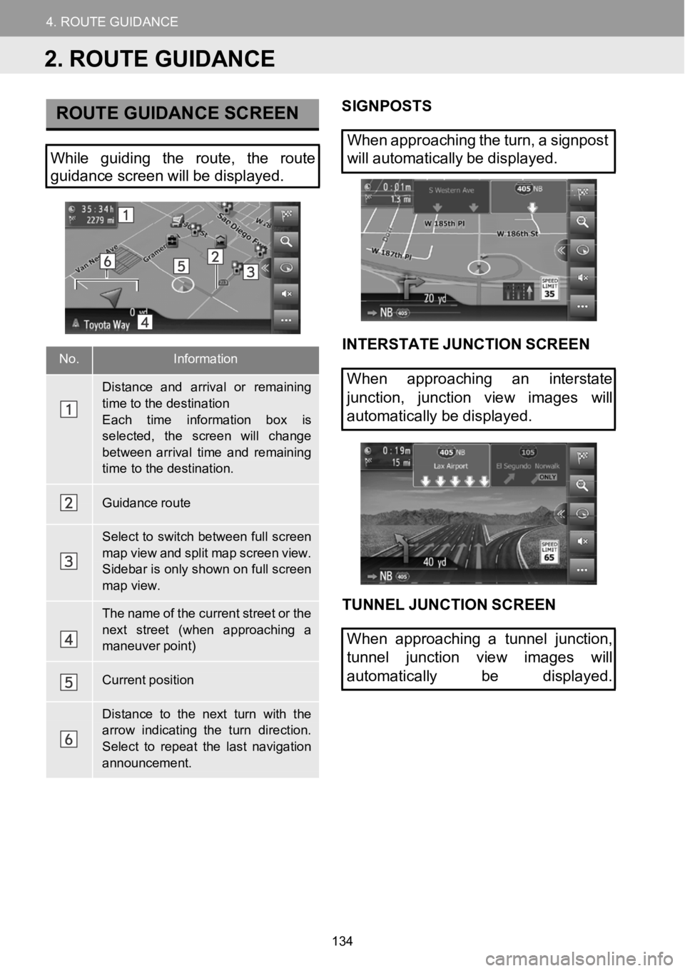
4.ROUTEGUIDANCE
1.STARTINGROUTEGUIDANCE
4.ROUTEGUIDANCE
No.Information
Distanceand arriv alor remaining
time to the destinationEach time information b ox is
selected, thescreen wi llchangebetwe en arrival ti meand remaining time to the destination.
Guidance route
Select to switchbetween full screen
map view and splitmap screen view.Sidebar isonly shown on fullscreenmap view.
Thename of the current street or the
next street (when approaching a maneuver point)
Current position
Distance to the next turn withthearrow indicating the turn direction.
Select to repeat the last navigation announcement.
ROUTE GUIDANCE SCREENSIGNPOS TS
When approaching the turn, asig npost
Wh ile guiding the route, the route
guidance screen willbedisp layed. will
automatically be di splayed.
INTERST ATE JUNCTION SCREEN
When approaching an interstate
junction, junction view images will
automat icallybe displ ayed.
TUNNEL JUN CTION SCREEN
When approaching a tunnel junction,
tunnel junction view images will
automatically be displayed.
2. ROUTE GUIDANCE
134
Page 136 of 164

4. ROUTE GUIDANCE
WARNING
Be sure to obey the
traffic regulations
and keep the road conditio n in mi nd
especial ly wh en you are driving on IP D
roads (roads that are not completely
d ig iti zed in the navigation dat abase).
Th e rou te guid ance may not have the
upd ated in formation such as the
d irec tion of a one-wa y st reet.
136