MERCEDES-BENZ CL COUPE 2009 Owners Manual
Manufacturer: MERCEDES-BENZ, Model Year: 2009, Model line: CL COUPE, Model: MERCEDES-BENZ CL COUPE 2009Pages: 421, PDF Size: 10.78 MB
Page 131 of 421
=
Last map scale selected (prior to calling
up the scale bar)
? Scale bar
Storing the current vehicle position as
a destination in the list of previous des-
tinations X
Make sure that the menu system is shown.
X To store: selectPosition QSave
vehicle position.
COMAND stores the current vehicle posi-
tion as a destination in the list of previous
destinations (Y page 160).
Moving the map i
It is only possible to move the map with
the menu system hidden. In certain coun-
tries, it is not possible to move the map
freely if the vehicle is travelling at more
than approximately 5 km/h. As soon as the
vehicle speed drops below about 3 km/h,
it is possible to move the map freely again.
X Slide ZVÆ, XVYoraVb.
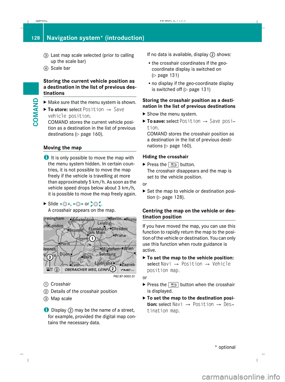
A crosshair appears on the map. :
Crosshair
; Details of the crosshair position
= Map scale
i Display ;may be the name of a street,
for example, provided the digital map con-
tains the necessary data. If no data is available, display
;shows:
R the crosshair coordinates if the geo-
coordinate display is switched on
(Y page 131)
R no display if the geo-coordinate display
is switched off (Y page 131)
Storing the crosshair position as a desti-
nation in the list of previous destinations
X Show the menu system.
X To save: selectPosition QSave posi‐
tion.
COMAND stores the crosshair position as
a destination in the list of previous desti-
nations (Y page 160).
Hiding the crosshair
X Press the %button.
The crosshair disappears and the map is
set to the vehicle position.
or
X Set the map to vehicle or destination posi-
tion (Y page 128).
Centring the map on the vehicle or des-
tination position If you have moved the map, you can use this
function to rapidly return the map to the posi-
tion of the vehicle or destination. You can only
use this function when route guidance is
active.
X
To set the map to the vehicle position:
select NaviQPosition QVehicle
position map.
or
X Press the %button when the crosshair
is displayed.
X To set the map to the destination posi-
tion: select NaviQPosition QDes‐
tination map. 128
Navigation system* (introduction)COMAND
* optional
216_AKB; 2; 3, en-GB
bjanott,
Version: 2.11.7.7 2009-02-27T14:54:17+01:00 - Seite 128
Dateiname: 6515230602_buchblock.pdf; erzeugt am 04. Mar 2009 11:15:13; WK
Page 132 of 421
Menu overview
Info (only
with route
guidance
active) TMC Route Position +
+ (only
with route
guidance
active) Destination
Display infor-
mation on
the current
route guid-
ance Calling up
RDS-TMC
traffic
reports R
Calling up
the traffic
jam func-
tion
R Calling up
symbol
info
R Calling up
route info R
Saving
vehicle
position
R Where am
I?
R Centring
the map on
the vehi-
cle's posi-
tion
R Destina-
tion on the
map
R Intermedi-
ate stop on
the map
R Compass Calling up
the current
navigation
announce-
ment R
Entering a
destina-
tion or an
intermedi-
ate stop
R Storing a
destina-
tion Basic settings
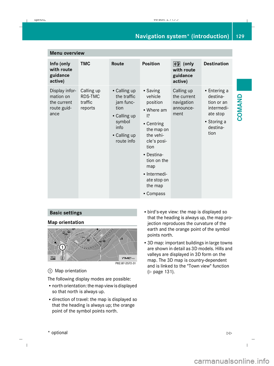
Map orientation :
Map orientation
The following display modes are possible:
R north orientation: the map view is displayed
so that north is always up.
R direction of travel: the map is displayed so
that the heading is always up; the orange
point of the symbol points north. R
bird's-eye view: the map is displayed so
that the heading is always up, the map pro-
jection reproduces the curvature of the
earth and the orange point of the symbol
points north.
R 3D map: important buildings in large towns
are shown in detail as 3D models. Hills and
valleys are displayed in 3D form on the
map. The 3D map is country-dependent
and is linked to the "Town view" function
(Y page 131). Navigation system* (introduction)
129COMAND
* optional
216_AKB; 2; 3, en-GB
bjanott,
Version: 2.11.7.7 2009-02-27T14:54:17+01:00 - Seite 129 Z
Dateiname: 6515230602_buchblock.pdf; erzeugt am 04. Mar 2009 11:15:13; WK
Page 133 of 421
X
To set the map orientation: selectNavi
Q Map display.
The map display list appears. A #dot indi-
cates the current setting.
X Select North orientation, Direction
of travel ,Bird's-eye-view or3-D
map .
X To exit the menu: slideXVY.
Setting special destination symbols You can set the special destinations you wish
to have displayed as symbols on the map.
Special destinations are, for example, filling
stations, hotels, cinemas and restaurants.
The following settings are possible:
R Standard symbols (symbol display deter-
mined by the factory settings)
R Personal symbols (you can determine
the symbols yourself)
R No symbols
X To set: selectNaviQSpecial desti‐
nation symbols on map .
The map display list appears. A #dot indi-
cates the current setting.
X Select Standard symbols orPersonal
symbols orNo symbols.
If you select Personal symbols, the list of
special destinations appears.
X To activate/deactivate the symbol dis-
play: select the respective special destina-
tion.
Depending on their previous status the
symbols are switched on/off. If a tick is
shown, this indicates that the display is
switched on. You can switch on the symbol
displays for more than one special destina-
tion.
i The list shows all symbols that are con-
tained on the digital map across all coun-
tries. However, not all special destinations
are available in all countries. As a result,
certain special destination symbols may not be displayed on the map, even if the
symbol display is switched on.
X To exit the menu: slideXVY.
Selecting text information on the map Below the map shown, COMAND can display
various items of text information:
R time of arrival and distance from destina-
tion
R current street
R geo-coordinates
R none
Arrival time and distance to destination
X To display: selectNaviQText infor‐
mation on map .
The selection list appears. A #dot indi-
cates the current setting.
X Select Arrival time/Distance.
This will switch the display for arrival time
and distance to destination on or off,
depending on the previous setting.
Current street
You can set whether COMAND displays the
street you are currently driving on at the bot-
tom of the map.
X To display: selectNaviQText infor‐
mation on map .
The selection list appears. A #dot indi-
cates the current setting.
X Select Current street .
This will either show or hide the current
street, depending on the previous setting. 130
Navigation system* (introduction)COMAND
* optional
216_AKB; 2; 3, en-GB
bjanott,
Version: 2.11.7.7 2009-02-27T14:54:17+01:00 - Seite 130
Dateiname: 6515230602_buchblock.pdf; erzeugt am 04. Mar 2009 11:15:13; WK
Page 134 of 421
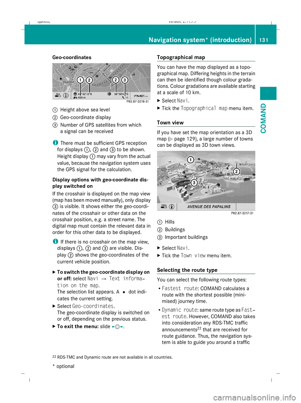
Geo-coordinates
:
Height above sea level
; Geo-coordinate display
= Number of GPS satellites from which
a signal can be received
i There must be sufficient GPS reception
for displays :,;and =to be shown.
Height display :may vary from the actual
value, because the navigation system uses
the GPS signal for the calculation.
Display options with geo-coordinate dis-
play switched on
If the crosshair is displayed on the map view
(map has been moved manually), only display
= is visible. It shows either the geo-coordi-
nates of the crosshair or other data on the
crosshair position, e.g. a street name. The
digital map must contain the relevant data in
order for this other data to be displayed.
i If there is no crosshair on the map view,
displays :,;and =are visible. Dis-
play ;shows the geo-coordinates of the
current vehicle position.
X To switch the geo-coordinate display on
or off: selectNaviQText informa‐
tion on the map.
The selection list appears. A #dot indi-
cates the current setting.
X Select Geo-coordinates.
The geo-coordinate display is switched on
or off, depending on the previous status.
X To exit the menu: slideXVY. Topographical map You can have the map displayed as a topo-
graphical map. Differing heights in the terrain
can then be identified though colour grada-
tions. Colour gradations are available starting
at a scale of 10 km.
X Select Navi.
X Tick the Topographical map menu item.
Town view If you have set the map orientation as a 3D
map (Y
page 129), a large number of towns
can be displayed as 3D town views. :
Hills
; Buildings
= Important buildings
X Select Navi.
X Tick the Town view menu item.
Selecting the route type You can select the following route types:
R
Fastest route: COMAND calculates a
route with the shortest possible (mini-
mised) journey time.
R Dynamic route: same route type as Fast‐
est route. However, COMAND also takes
into consideration any RDS-TMC traffic
announcements 22
that are received for
route guidance. Thus, the navigation sys-
tem is able to guide you around a traffic
22 RDS-TMC and Dynamic route are not available in all countries. Navigation system* (introduction)
131COMAND
* optional
216_AKB; 2; 3, en-GB
bjanott,
Version: 2.11.7.7 2009-02-27T14:54:17+01:00 - Seite 131 Z
Dateiname: 6515230602_buchblock.pdf; erzeugt am 04. Mar 2009 11:15:13; WK
Page 135 of 421
jam, for example. If a quicker route is deter-
mined due to a received RDS-TMC traffic
announcement, the navigation system
changes the route. If possible, it will bypass
blockages.
R Short route: COMAND calculates a route
with the shortest possible (minimised) dis-
tance regarding distance and driving time.
X Select NaviQMode:
The mode list appears.
The current setting is indicated by a #dot.
X To make a setting: selectFastest
route orDynamic route orShort
route.
X To exit the menu: slideXVY.
i COMAND calculates a new route if you
change the route type setting with route
guidance active. If you change the route
type setting when route guidance is inac-
tive, COMAND uses the new setting for the
next route guidance.
Setting route options This function allows you to set the following
options for route guidance:
R Avoid motorways
R Avoid toll roads
R Avoid routes requiring special
toll sticker
R Avoid tunnels
R Avoid ferries
R Avoid motorail trains
X Select NaviQMode:
The mode list appears.
The selected option is indicated by a O
tick. It is possible to select more than one
option.
X To activate or deactivate an option:
select the desired option.
The option is selected or deselected,
depending on the previous status. X
To exit the menu: slideXVY.
COMAND will verify whether it can imple-
ment the options if you have selected them
with route guidance active. If it can,
COMAND calculates a new route while
implementing the options selected. If it
cannot, you will see and hear a correspond-
ing message.
X Select OK.
COMAND calculates a new route. Only
those options which can be implemented
are considered. Installing map software
The digital maps generated by the map soft-
ware become outdated in the same way as
conventional road maps. Optimum route
guidance can only be provided by the naviga-
tion system in conjunction with the most up-
to-date map software. Information about new
map software versions can be obtained from
a Mercedes-Benz Service Centre.
You can install new map software, which may
consist of one of more DVDs (depending on
the scope), yourself.
The installation process can take between
10 and 120 minutes, depending on the scope
of the map software. If the radio is switched
on before you start the installation process,
you can still adjust the volume. You can also
use COMAND to operate the automatic air-
conditioning system and to cancel the proc-
ess. Other functions are not operational. If
possible, carry out the installation process
when the vehicle is stationary. The DVD read
speed is higher when the vehicle is stationary
than when it is in motion, so less time is
required. If the starter battery is not suffi-
ciently charged, COMAND may end the proc-
ess automatically, in order to protect the bat-
tery. Therefore, let the engine idle during the
installation process. 132
Navigation system* (introduction)COMAND
* optional
216_AKB; 2; 3, en-GB
bjanott,
Version: 2.11.7.7 2009-02-27T14:54:17+01:00 - Seite 132
Dateiname: 6515230602_buchblock.pdf; erzeugt am 04. Mar 2009 11:15:14; WK
Page 136 of 421
G
Risk of poisoning
Never leave the engine running in enclosed
spaces. The exhaust gases contain carbon
monoxide. Inhaling exhaust fumes consti-
tutes a health hazard and could lead to loss
of consciousness or even death.
Displaying information on the currently
used map version X
Select NaviQMap version.
Notes on handling DVDs R
Only hold DVDs by the edge.
R Handle DVDs carefully to prevent reading
errors.
R Avoid getting scratches, fingerprints and
dust on DVDs.
R Use a commercially-available cleaning
cloth to clean discs. Do not wipe them with
a circular motion, but only in straight lines
from the centre outwards.
R Place DVDs back in their cases after use.
R Protect DVDs from heat and direct sunlight.
Map software copy protection Map software for COMAND is subject to a
charge. The map software has just one acti-
vation code which is usable in one vehicle
only, and is not transferable. You can obtain
the six digit activation code from your
Mercedes-Benz Service Centre. If you have
lost the activation code, or if COMAND does
not accept the activation code that you have
received, ask at your Mercedes-Benz Service
Centre.
Your vehicle is supplied with map software at
the factory. Depending on the country, the
map software for your region is either pre-
installed (Europe/USA), or the map software
is provided on a DVD (all other countries). You
do not require an activation code for the map
software that is provided with your vehicle. If the map software on your vehicle has been
installed at the factory and you wish to rein-
stall it, this also does not necessitate entry of
the activation code.
Installation process X
Insert the map software DVD into the single
DVD drive (Y page 77) or the DVD
changer* (Y page 78).
COMAND checks the DVD and shows a
corresponding message in the display.
The map software is not compatible with
the navigation system
You will see a message that the installation of
the map software is not possible.
X To confirm the message: pressW.
COMAND ejects the DVD.
X Take the DVD out of the slot.
X Insert a DVD which is compatible with the
vehicle’s navigation system.
The map software is not compatible with
the current system software
You will see a message that the system soft-
ware and the map software are not compati-
ble.
X To confirm the message: pressW.
COMAND ejects the DVD.
X Take the DVD out of the slot.
X Have the system software updated at a
Mercedes-Benz Service Centre.
The map software cannot be installed until
the system software has been updated.
Map software compatible with the navi-
gation system and the current system
software
COMAND checks whether the map data on
the DVD is already installed.
Map data is already installed
You will see a message that the map data is
already installed and a prompt will appear
asking you whether you wish to continue with
the installation. Navigation system* (introduction)
133COMAND
* optional
216_AKB; 2; 3, en-GB
bjanott,
Version: 2.11.7.7 2009-02-27T14:54:17+01:00 - Seite 133 Z
Dateiname: 6515230602_buchblock.pdf; erzeugt am 04. Mar 2009 11:15:14; WK
Page 137 of 421
X
Select YesorNo.
If you select Yes, the existing map data is
overwritten.
If you select No, COMAND automatically
ejects the DVD and the installation of the
map software is cancelled.
X Take the DVD out of the slot.
Map data is not yet installed
To compare the map software DVD and the
map software currently installed on
COMAND, the status of the versions is dis-
played. Subsequently a prompt will appear
asking whether you wish to continue with the
map software installation.
X Select YesorNo.
If you select Yes, the map data is installed.
If you select No, COMAND automatically
ejects the DVD and the installation of the
map software is cancelled.
X Take the DVD out of the slot.
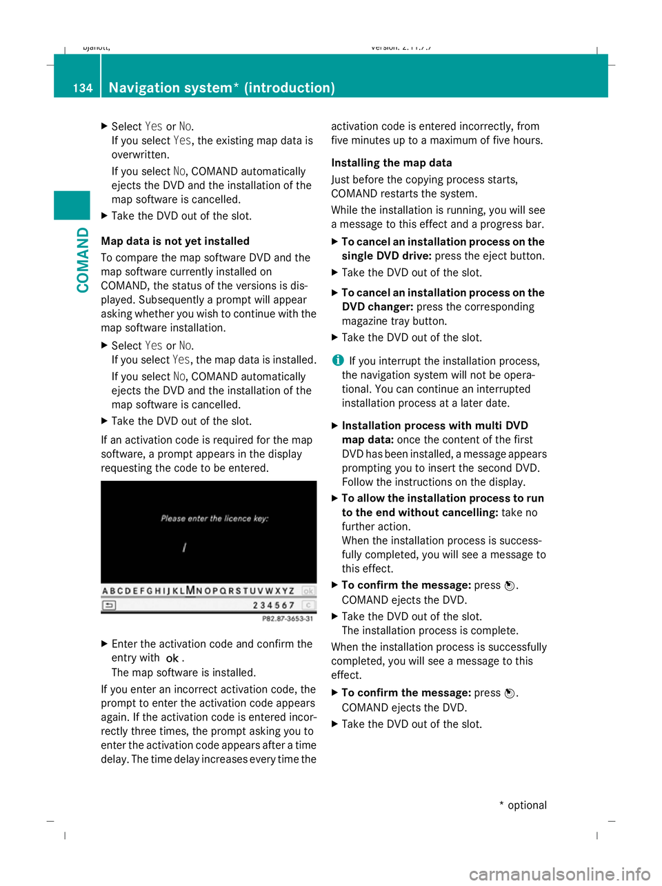
If an activation code is required for the map
software, a prompt appears in the display
requesting the code to be entered. X
Enter the activation code and confirm the
entry with !.
The map software is installed.
If you enter an incorrect activation code, the
prompt to enter the activation code appears
again. If the activation code is entered incor-
rectly three times, the prompt asking you to
enter the activation code appears after a time
delay. The time delay increases every time the activation code is entered incorrectly, from
five minutes up to a maximum of five hours.
Installing the map data
Just before the copying process starts,
COMAND restarts the system.
While the installation is running, you will see
a message to this effect and a progress bar.
X
To cancel an installation process on the
single DVD drive: press the eject button.
X Take the DVD out of the slot.
X To cancel an installation process on the
DVD changer: press the corresponding
magazine tray button.
X Take the DVD out of the slot.
i If you interrupt the installation process,
the navigation system will not be opera-
tional. You can continue an interrupted
installation process at a later date.
X Installation process with multi DVD
map data: once the content of the first
DVD has been installed, a message appears
prompting you to insert the second DVD.
Follow the instructions on the display.
X To allow the installation process to run
to the end without cancelling: take no
further action.
When the installation process is success-
fully completed, you will see a message to
this effect.
X To confirm the message: pressW.
COMAND ejects the DVD.
X Take the DVD out of the slot.
The installation process is complete.
When the installation process is successfully
completed, you will see a message to this
effect.
X To confirm the message: pressW.
COMAND ejects the DVD.
X Take the DVD out of the slot. 134
Navigation system* (introduction)COMAND
* optional
216_AKB; 2; 3, en-GB
bjanott,
Version: 2.11.7.7 2009-02-27T14:54:17+01:00 - Seite 134
Dateiname: 6515230602_buchblock.pdf; erzeugt am 04. Mar 2009 11:15:14; WK
Page 138 of 421
If the installation process cannot be success-
fully completed, this may be due to the fol-
lowing:
R
DVD dirty or scratched
XClean the DVD (Y page 133).
X Restart the map software installation
process.
R Overheating due to excessive tempera-
tures in the vehicle interior.
XWait until the vehicle interior has
cooled down.
X Restart the map software installation
process.
R If the measures listed above do not solve
the problem:
XConsult a Mercedes-Benz Service
Centre. Navigation system* (entering a desti-
nation) Introduction to entering destinations
The following destination input options are
available:
R entering a destination by address
R entering a destination from the destination
memory
R entering a destination from the list of last
destinations
R entering a destination using the map
R entering an intermediate stop
R entering a special destination Entering a destination by address
i In certain countries, it is not possible to
enter an address if the vehicle is travelling
at more than approximately 5 km/h. As
soon as the vehicle speed drops below about 3 km/h, the function is available
again.
When entering an address as the destination,
you have the following options:
R enter the country, town and street.
R enter the country, town and centre.
R enter the country, town, street and house
number.
R enter the country, town, street and junc-
tion.
R enter the country, town and street.
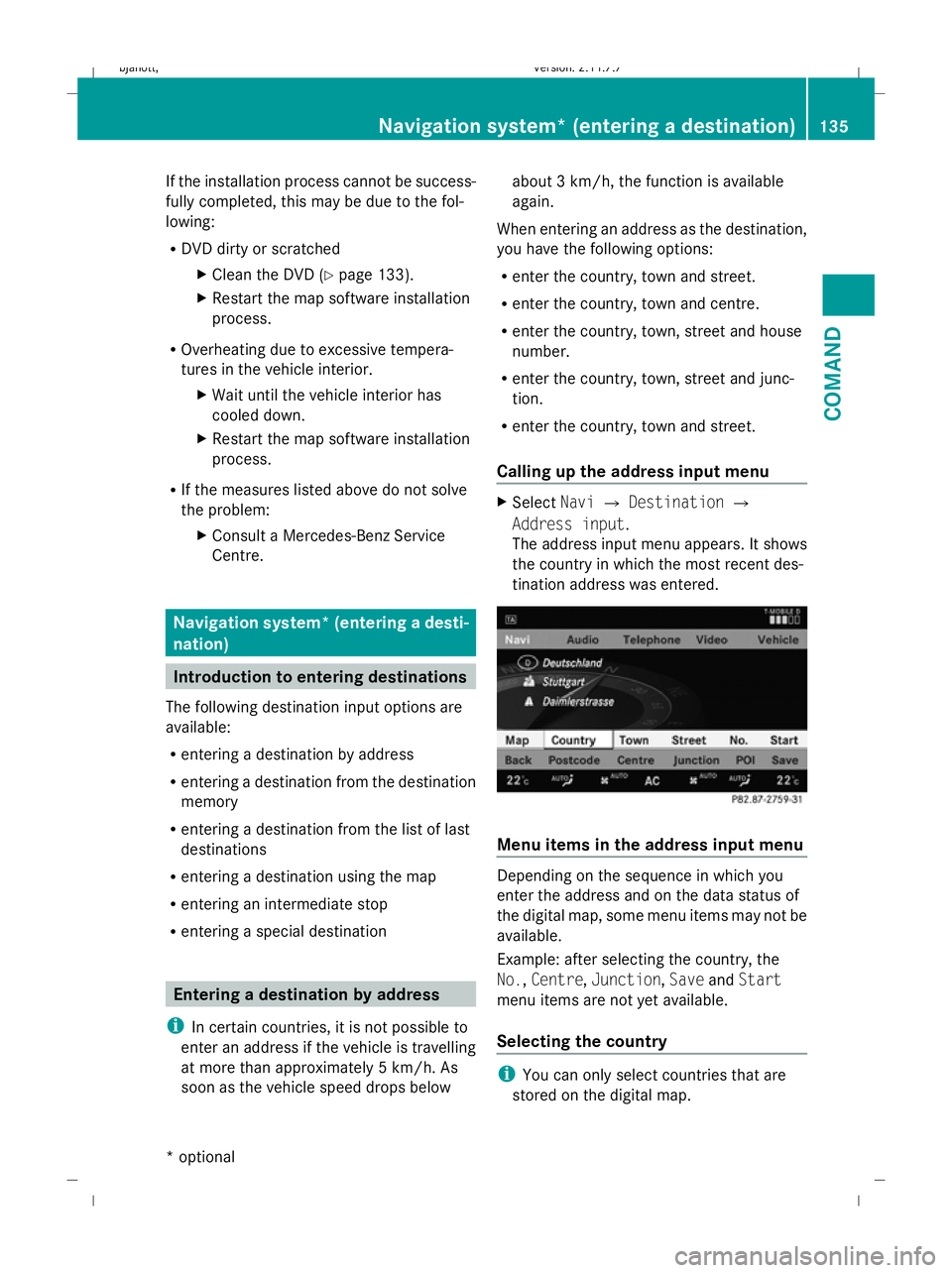
Calling up the address input menu X
Select NaviQDestination Q
Address input.
The address input menu appears. It shows
the country in which the most recent des-
tination address was entered. Menu items in the address input menu
Depending on the sequence in which you
enter the address and on the data status of
the digital map, some menu items may not be
available.
Example: after selecting the country, the
No.,
Centre, Junction, SaveandStart
menu items are not yet available.
Selecting the country i
You can only select countries that are
stored on the digital map. Navigation system* (entering a destination)
135COMAND
* optional
216_AKB; 2; 3, en-GB
bjanott,
Version: 2.11.7.7
2009-02-27T14:54:17+01:00 - Seite 135 Z
Dateiname: 6515230602_buchblock.pdf; erzeugt am 04. Mar 2009 11:15:14; WK
Page 139 of 421
X
Select Country in the address input menu.
The country list appears.
X Select the desired country.
The address input menu appears again. The
country selected is automatically entered.
Entering the town i
You can only enter towns that are stored
on the digital map. Entering a town will
delete a previously entered postcode.
X Select Townin the address input menu.
The list of towns appears either with or
without the input speller. Whether or not
the input speller is displayed depends on
how many towns are available for the coun-
try selected.
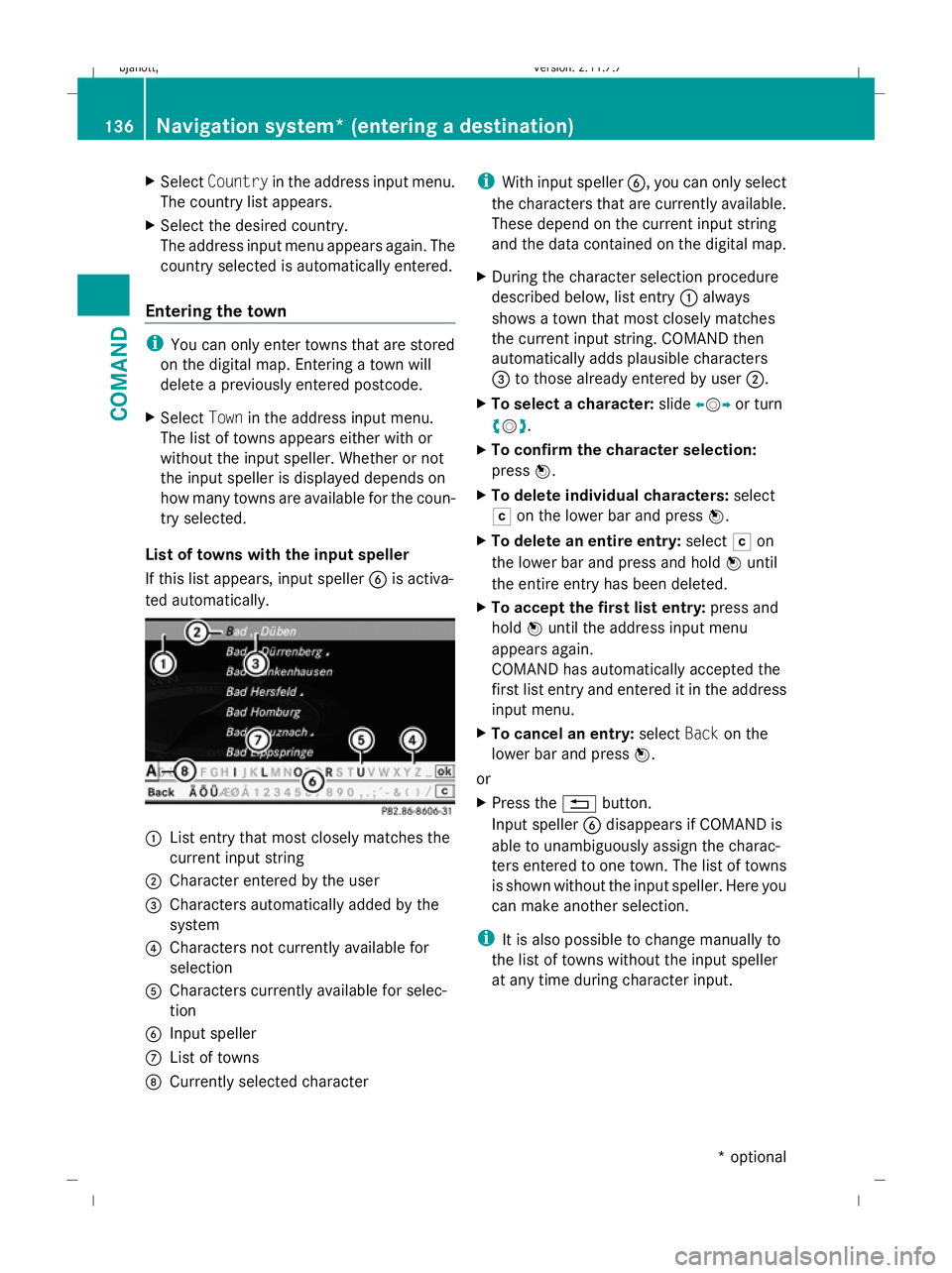
List of towns with the input speller
If this list appears, input speller Bis activa-
ted automatically. :
List entry that most closely matches the
current input string
; Character entered by the user
= Characters automatically added by the
system
? Characters not currently available for
selection
A Characters currently available for selec-
tion
B Input speller
C List of towns
D Currently selected character i
With input speller B, you can only select
the characters that are currently available.
These depend on the current input string
and the data contained on the digital map.
X During the character selection procedure
described below, list entry :always
shows a town that most closely matches
the current input string. COMAND then
automatically adds plausible characters
= to those already entered by user ;.
X To select a character: slideXVY or turn
cVd .
X To confirm the character selection:
press W.
X To delete individual characters: select
F on the lower bar and press W.
X To delete an entire entry: selectFon
the lower bar and press and hold Wuntil
the entire entry has been deleted.
X To accept the first list entry: press and
hold Wuntil the address input menu
appears again.
COMAND has automatically accepted the
first list entry and entered it in the address
input menu.
X To cancel an entry: selectBackon the
lower bar and press W.
or
X Press the %button.
Input speller Bdisappears if COMAND is
able to unambiguously assign the charac-
ters entered to one town. The list of towns
is shown without the input speller. Here you
can make another selection.
i It is also possible to change manually to
the list of towns without the input speller
at any time during character input. 136
Navigation system* (entering a destination)COMAND
* optional
216_AKB; 2; 3, en-GB
bjanott,
Version: 2.11.7.7 2009-02-27T14:54:17+01:00 - Seite 136
Dateiname: 6515230602_buchblock.pdf; erzeugt am 04. Mar 2009 11:15:14; WK
Page 140 of 421
X
To change manually to the list of towns
without the input speller: slideZV.
or
X Select !on the second lowest bar and
press W.
Selecting the current town The "Town" entry is always empty at first
because of the "Street destination"
(Y
page 142) option in the "Address" menu.
You may select the last town name entered
by selecting the last destination from Desti‐
nation QFrom last destinations and
pressing Change.
Inputting Cyrillic characters In Russia, you may choose between Cyrillic
and Latin characters to input destinations. In
order to do this, you must have installed the
map software for Russia.
X To switch between Latin and Cyrillic
fonts: select the psymbol from the
input speller menu.
Entering a postcode i
Entering a postcode will delete a previ-
ously entered town name. You can only
enter postcodes that are stored on the dig-
ital map.
X Select Postcode in the address input
menu.
The postcode list appears either with or
without the input speller. Whether or not
the input speller is displayed depends on
how many postcodes are available for the
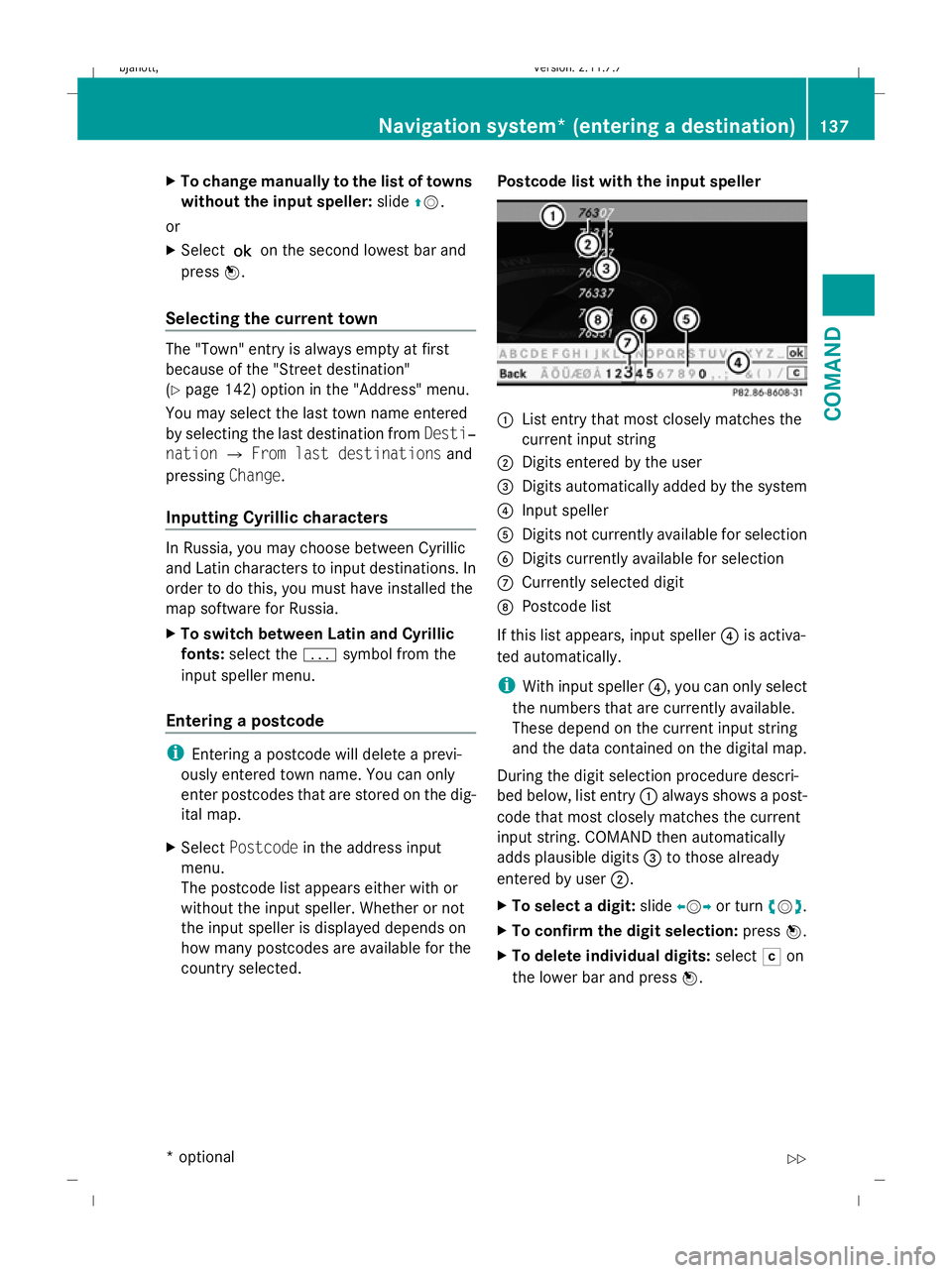
country selected. Postcode list with the input speller :
List entry that most closely matches the
current input string
; Digits entered by the user
= Digits automatically added by the system
? Input speller
A Digits not currently available for selection
B Digits currently available for selection
C Currently selected digit
D Postcode list
If this list appears, input speller ?is activa-
ted automatically.
i With input speller ?, you can only select
the numbers that are currently available.
These depend on the current input string
and the data contained on the digital map.
During the digit selection procedure descri-
bed below, list entry :always shows a post-
code that most closely matches the current
input string. COMAND then automatically
adds plausible digits =to those already
entered by user ;.
X To select a digit: slideXVYor turn cVd.
X To confirm the digit selection: pressW.
X To delete individual digits: selectFon
the lower bar and press W. Navigation system* (entering a destination)
137COMAND
* optional
216_AKB; 2; 3, en-GB
bjanott,
Version: 2.11.7.7 2009-02-27T14:54:17+01:00 - Seite 137 Z
Dateiname: 6515230602_buchblock.pdf; erzeugt am 04. Mar 2009 11:15:15; WK