display MERCEDES-BENZ R-Class 2011 W251 Comand Manual
[x] Cancel search | Manufacturer: MERCEDES-BENZ, Model Year: 2011, Model line: R-Class, Model: MERCEDES-BENZ R-Class 2011 W251Pages: 214, PDF Size: 4.69 MB
Page 74 of 214
X
Sel ect Route in
the navi gation menu bar
us ing the :=; buttons and
pre ssthe 9button toconfi rm.
X Sel ect RouteBrowser and
pressthe 9
bu tton toconfi rm.
At the top ofthe displ ay,yo uwi llsee
info rma tion abou tthe highlighted route
section, forexample thedistance tobe driven
on the road androad designation. The
highlighted routesection ismarked inwhite
with ared border onthe map.
X To view thenext orprevious route
section: selectNext or
Previous and
press the9button toconfirm .
i Ifthe first orlast route section is
highlighted, youcannot selectPrevious or
Next .
X To zoom inor out ofthe map :select N
or M and press the9button toconfirm .
X To close theroute browser: selectBack and
press the9button toconfirm . Off-r
oadand off-ma p
Route guidance toan off-road
destination G
Warning
The COMAND navigation systemmaydirect
you tooff-road routesthatyour vehicle may
not becapable oftraversing throughwithout
damaging yourtires, wheels orvehicle. Itis
the driver’s soleresponsibility todetermine
the suitabili tyof the route. Off-roadroutes
may beofvarying condition sand their
appropriateness foruse may beaffected by
various factorssuchastime ofday, time of
year andimmediate weathercondition sthat
cannot bejudged ortaken intoconsideration
by the COMAND system.
COMAND canguide youtodestinations
which arewithin thearea covered bythe digital
map,butwhich arenot themselves
recorded onthe map.
These destinations areknown asoff-r oad
destinations, whichyoucan enter using the
map, forexample. Inthese cases, COMAND
guides youforaslong aspossible with
navigation announcemen tsand displa yson
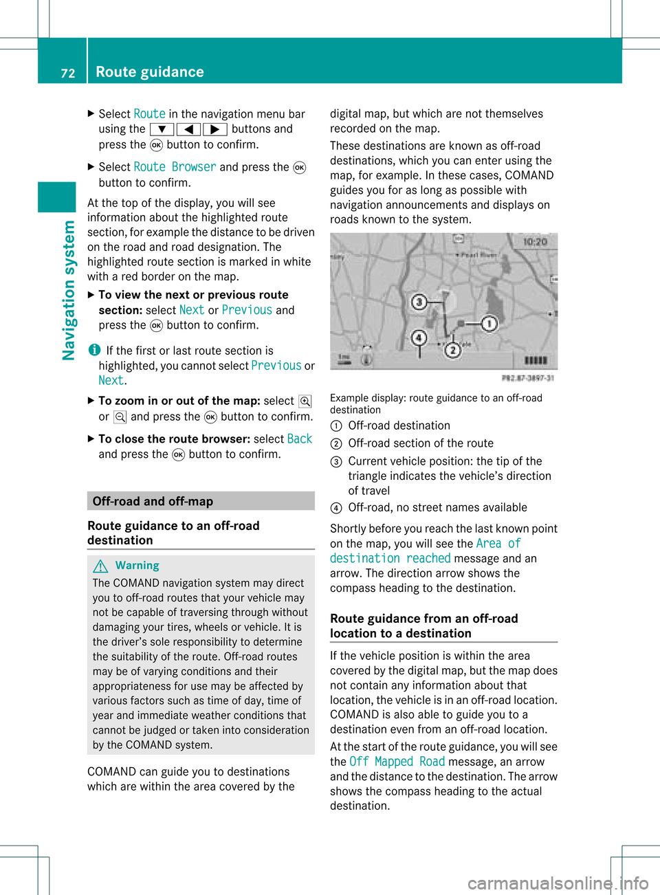
roads known tothe system. Example
display:route guidance toan off-r oad
destination
: Off- road destination
; Off- road section ofthe route
= Current vehicleposition: thetipofthe
triangle indicates thevehicle’s direction
of travel
? Off- road, nostreet names available
Short lybefore youreach thelast known point
on the map, youwillsee theArea of destination
reached message
andan
arrow. Thedirection arrowshows the
compass headingtothe destination .
Route guidance fromanoff-road
location toad esti nation If
th evehi cleposit ioniswith inthearea
cov ered bythedigit almap, butthemap does
no tcon tain anyinform ationabout that
locat ion,th evehi cleisin an off-road locat ion.
COMA NDisalso able toguide youtoa
dest inationeven from anoff-road locat ion.
At thest art oftherout eguidan ce,you willsee
th eOff Mapped Road mes
sage, anarro w
and thedist anceto thed estin ation. Thearrow
shows thecompass headingtothe actual
destin ation. 72
Rout
eguida nceNavigation system
Page 77 of 214
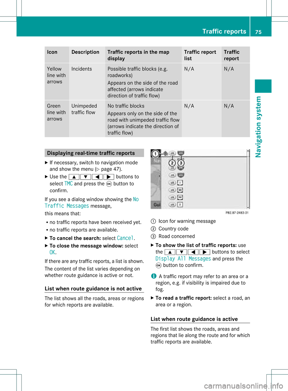
Icon Descr
iption Tr
affic rep ortsin thema p
dis pla y Tr
affic rep ort
list Tr
affic
rep ort Yellow
lin ewit h
arr ows In
cid ents Poss
ibletraff icbloc ks(e.g.
road work s)
Ap pear son theside ofther oad
affect ed(arrows indicate
direction oftraffic flow) N/A N/A
Green
line with
arrows Unimpeded
traffic flow No
traffic blocks
Appears onlyonthe side ofthe
road withunimpeded trafficflow
(arrows indicate thedirection of
traffic flow) N/A N/A
Displaying
real-timetraffic repor ts
X Ifnecessary, switchtonavigation mode
and show themenu (Ypage 47).
X Use the9:=; buttonsto
select TMC and
press the9button to
conf irm.
If you seeadialog window showing theNo Traffic
Messages message,
this means that:
R no traffic reports havebeen received yet.
R no traffic reports areavaila ble.
X To cancel thesearch: selectCancel .
X To close themessage window:select
OK .
If there areany traffic reports, alist isshown.
The cont entofthe listvaries depending on
whether routeguidance isactive ornot .
List when routeguidance isnot active The
listshows allthe roads, areasorregions
for which reports areavaila ble. 1
Icon forwarning message
2 Country code
3 Road concerned
X To show thelistoftraffic report s:use
the 9:=; buttonsto select
Display AllMessages and
press the
9 button toconf irm.
i Atraffic report mayrefer toan area ora
region, e.g.ifvisibility isimpaired dueto
fog.
X To read atraffic report :select aroad, an
area oraregion.
List when routeguidance isactive The
first listshows theroads, areasand
regions thatliealong theroute andforwhich
traffic reports areavaila ble. Tr
affic repor ts
75Navigation system Z
Page 78 of 214
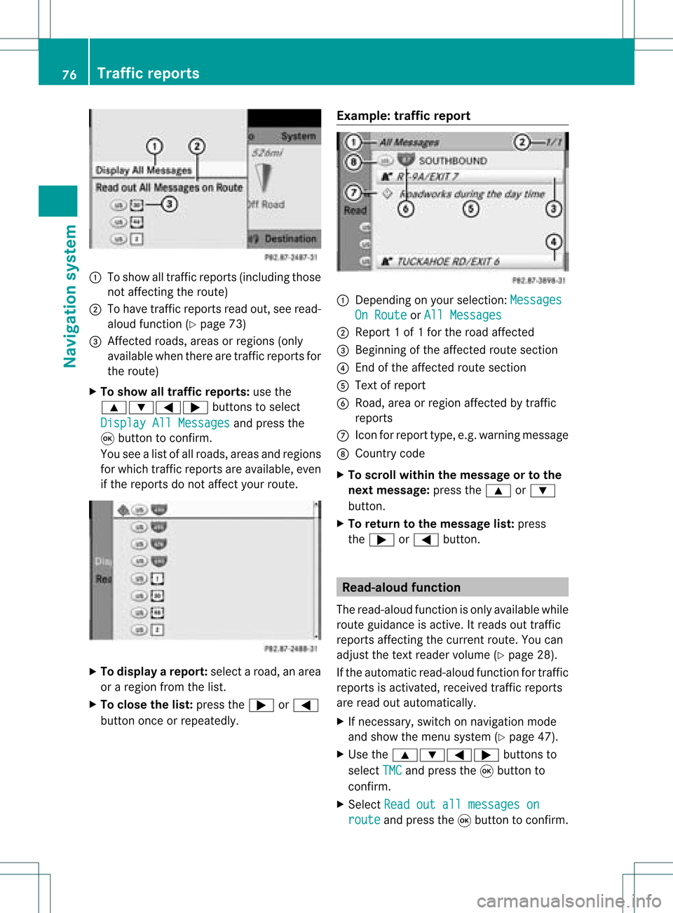
1
Toshow alltraff icreports (including those
not affect ingthe route)
2 Tohave trafficreports readout,seeread-
aloud function(Ypage 73)
3 Affected roads, areasorregions (only
availab lewhen therearetraff icreports for
the route)
X To show alltraffic repor ts:use the
9:=; buttonsto select
Display AllMessages and
press the
9 button toconf irm.
You seealist ofall roads, areasandregions
for which trafficreports areavailab le,even
if the reports donot affect yourroute. X
To display arepor t:select aroad, anarea
or aregion fromthelist.
X To close thelist: press the; or=
button onceorrepeatedly. Examp
le:traffic repor t 1
Dependin gon your selection :Messages On
Route or
All Messages 2
Report 1of 1for the road affect ed
3 Beginn ingofthe affect edroute section
4 Endof the affect edroute section
5 Text ofreport
6 Road, areaorregion affectedbytraff ic
reports
C Icon forreport type,e.g.warning message
D Country code
X To scroll within themessage ortothe
next message: pressthe9 or:
button .
X To retu rntothe message list:press
the ; or= button . Read-
aloud function
The read-aloud functionisonly availab lewhile
route guidance isactive. Itreads outtraff ic
reports affectingthe curren troute. Youcan
adjust thetext reader volume (Ypage 28).
If the automatic read-aloud functionfortraff ic
reports isactivat ed,received trafficreports
are read outautomatically.
X Ifnecess ary,switch onnavigation mode
and show themenu system (Ypage 47).
X Use the9:=; buttonsto
select TMC and
press the9button to
conf irm.
X Select Readoutallmessages on route and
press the9button toconf irm. 76
Tr
affic repor tsNavigation system
Page 79 of 214
COMA
NDread sout therep ortsin seque nce.
i The MessagesOnRoute men
uitem has
no fun ction ifth ere arenorep ortsrelat ing
to therout e.
X To swit choff therea d-alou dfu nct ion:
use the9:= ;buttons to
sele ctCan cel Rea
d-Aloud Fun
ction and
pre ssthe9 buttonto confirm .
COMA NDread sth ecur ren treport aloud
and then exitsthe read-aloud function.
X To cancel theread -aloud function for
the curr entrepor t:press thex button .
COMAND cancelsthe read-aloud function
for the curren treport .Subsequent reports
will still beread out. Destination
memory Home
address (Myaddress)
Entering thehome address viaadd ress
entry X
En ter the home address asadestin ation,
e.g. asacity, street and house number
(Y page 48).Then, savethehome address
without startingroute guidance
(Y page 52).
Adopt inganadd ress book entry asa
home address X
To switch onnavigat ionmode: pressthe
Ø function button .
X To show themenu: pressthe9button .
X Select Destina tion in
the navigation
menu barusing the:=;
button sand press the9button tocon firm.
X Select FromMemory and
press the9
button tocon firm.
You willsee thedestin ationmemory list
either withthecharact erbar (option 1)or
as aselect ionlist(option 2).
Opt ion 1:destina tionmem orylistwith
char acter bar X
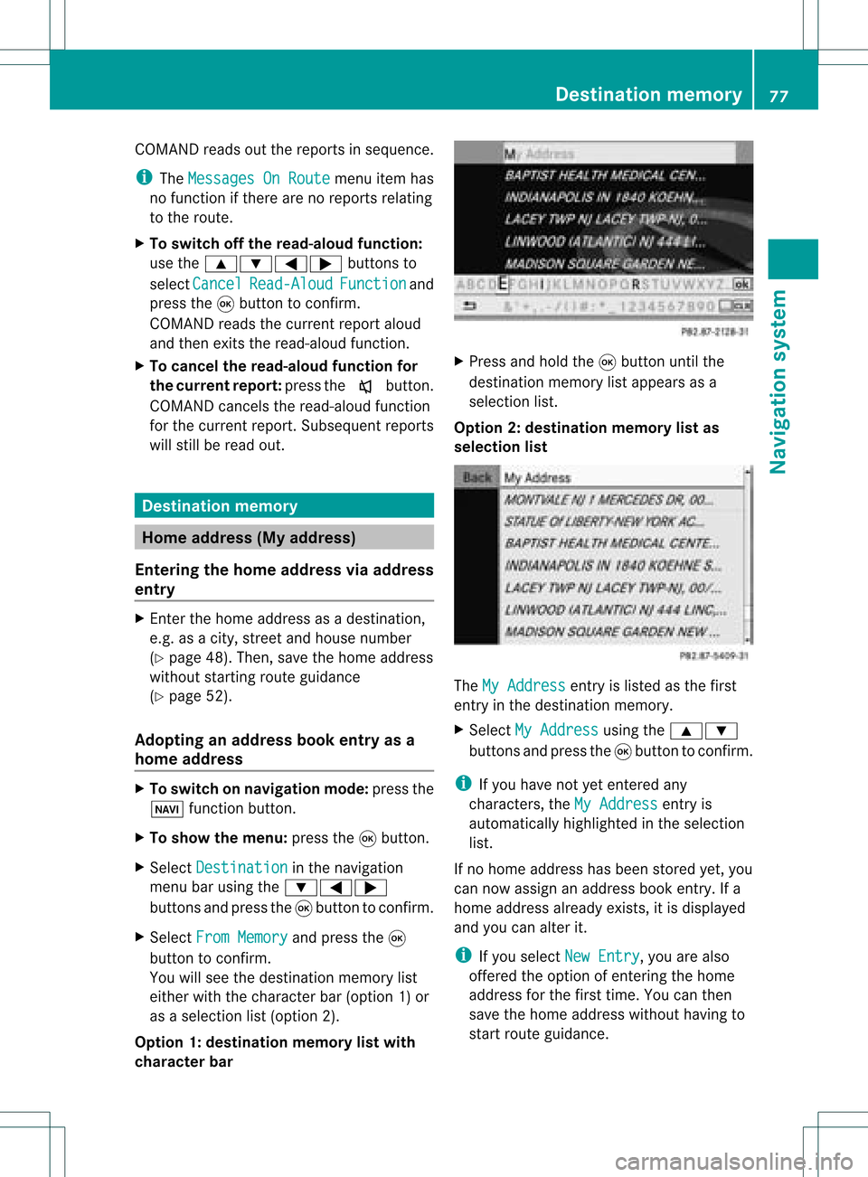
Press andhold the9button untilthe
destin ationmemory listappears asa
select ionlist.
Opt ion 2:destina tionmem orylistas
selection list The
MyAddress ent
ryislisted asthe first
ent ryinthe destin ationmemory.
X Select MyAddress using
the9:
button sand press the9button tocon firm.
i Ifyou have notyetentered any
charact ers,theMyAddress ent
ryis
automatic allyhighlighted inthe select ion
list.
If no home address hasbeen storedyet, you
can now assign anaddress bookentry.Ifa
home address alreadyexists,itis displayed
and youcan alter it.
i Ifyou select NewEntry ,
you arealso
offer edthe option ofent ering thehome
address forthe first time. Youcanthen
save thehome address withouthavingto
start route guidance. Destination
memory
77Navigation system Z
Page 83 of 214
Route
guidanc eis acti ve X
To sho wthe men u:pre ssthe 9button.
X Sel ect Posi tion in
the navi gation menu
ba ru sing the:=; buttonsand
press the9button toconfirm.
X Select Destination PositionMap and
press the9button toconfirm.
You willsee themap withacrosshair atthe
destination.
X To show themenu: pressthe9button.
X Select Position in
the navigation menu
bar using the:=; buttonsand
press the9button toconfirm.
X Select SaveCrosshair Position and
press the9button toconfirm.
COMAND storesthecrosshair positionas
a destination inthe listofprevious
destinations. Del
eting oneofthe previous
destinations
X To switch onnavigation mode:pressthe
Ø function button.
X To show themenu: pressthe9button.
X Select Position in
the navigation menu
bar using the:=; buttonsand
press the9button toconfirm.
X Select FromLastDestinations and
press the9button toconfirm.
The listofprevious destinations appears.
X Select thedesired destination andpress
the 9button toconfirm.
The destination addressappears.
X Select Delete and
press the9button to
confirm.
Ap rompt appears, asking whethe rthe
entr yshould bedeleted. X
Select Yes or
No and
press the9button
to confirm .
If you select Yes ,
the entr yis deleted.
If you select No ,
the process willbe
canceled. Map
operation andsettings Notes
Company logosdisplayedonthe map are
trademarks ofthe respective companies and
used solely forthe purpose ofindicating the
location ofthese companies. Theuseofsuch
logos forthe map does notindicate approval,
support oradvertisement ofthe navigation
system bythe respective companies. Adjust
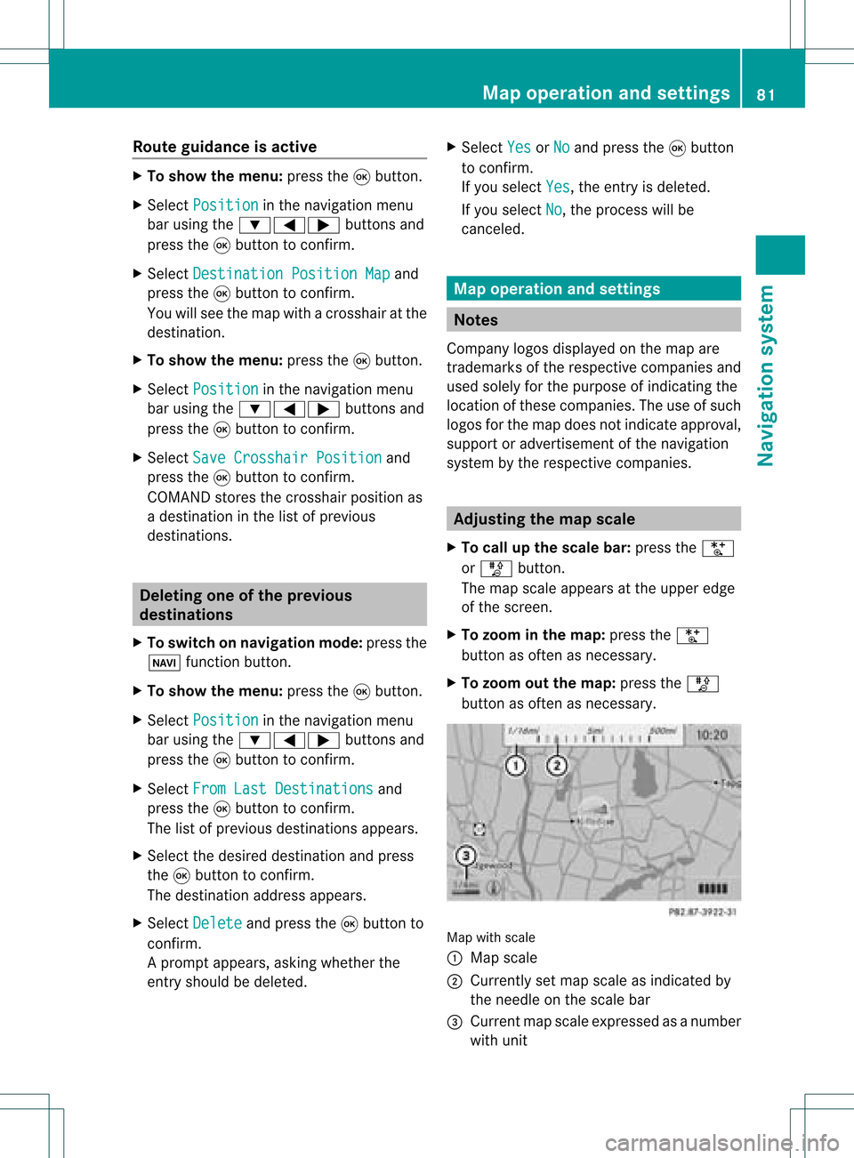
ingthe map scale
X To call upthe scale bar:press theU
or T button.
The map scale appea rsat the upper edge
of the screen.
X To zoom inthe map :press theU
button asoften asnecessary.
X To zoom outthemap :press theT
button asoften asnecessary. Map
withscale
: Map scale
; Currently setmap scale asindicated by
the needle onthe scale bar
= Current mapscale expressed asanumber
with unit Map
operat ionand settings
81Navigationsystem Z
Page 85 of 214
Map
display
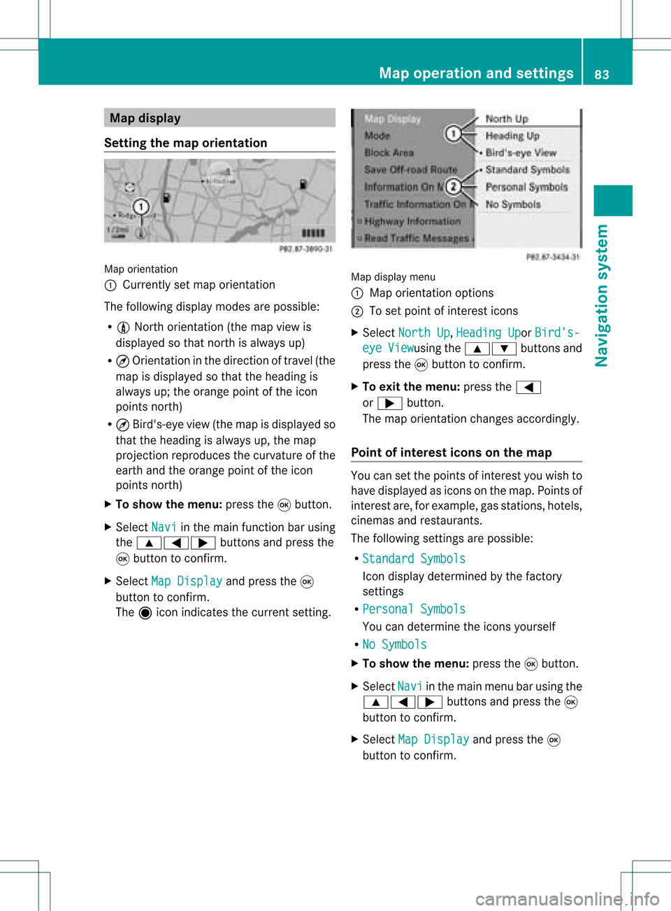
Setting themap orientation Map
orientati on
: Currently setmap orientati on
The followi ngdisp laymodes arepossi ble:
R 0 North orientati on(the map view is
disp layed sothat north isalw aysup)
R ¤ Orientati oninthe dire ction oftravel (the
map isdisp layed sothat theheading is
alw aysup; the orange pointofthe icon
poi nts north)
R ¤ Bird's-e yeview (themap isdisp layed so
that theheading isalw aysup, the map
projection reproducesthecurvatu reofthe
earth andtheorange pointofthe icon
poi nts north)
X To show themenu: pressthe9button.
X Select Navi in
the mainfunction barusing
the 9=; buttonsandpress the
9 button toconfirm.
X Select MapDisplay and
press the9
button toconfirm.
The äicon indica testhe current setting. Map
displaymenu
: Map orientati onoptions
; Toset pointofinterest icons
X Select North Up ,
Heading Up or
Bird's- eye View usi
ng the 9: buttonsand
press the9button toconfirm.
X To exitthe menu: pressthe=
or ; button.
The map orientati onchanges accordingly.
Poi ntofintere stico nson the map You
cansetthe points ofinterest youwishto
have displayed asicons onthe map. Points of
interest are,forexampl e,gas stations, hotels,
cinemas andrestau rants.
The followi ngsettings arepossi ble:
R Standar dSymbols Icon
displaydetermi nedbythe factory
settings
R Persona lSymbols You
candetermi nethe icons yourself
R No Symbols X
To show themenu: pressthe9button.
X Select Navi in
the mainmenu barusing the
9=; buttonsand press the9
button tocon firm.
X Select MapDisplay and
press the9
button tocon firm. Map
opera tionandsettings
83Navigation system Z
Page 86 of 214
X
Sel ect StandardSymbols ,
Per sonal Sym
bols or
No Sym bols .
If yo usel ect Per sonal Sym
bols ,
the list of
poi nts ofinter estappe ars .
X To switchthe ico ndisplay on/off:select
the pointofinterest using the 9:
buttons andpress the9button toconfirm.
Dependi ngon the previ oussetting, the
icons willbe swi tched onO oroff ª.Y ou
can switch onthe icon display sfor more
than onepoint ofinter est.
i The listshows allicons thatarecont ained
on the digital mapacross allcount ries.
However, notallpoints ofinter estare
availa bleinall count ries.Asaresult, certain
point ofinter esticons maynotbedisplay ed
on the map, evenifthe icon display is
switched on.
X To exit themenu: pressthe=
or ; button . Map
informa tioninthe display
Displaying mapinforma tion During
routeguidance, youcan have map
inform ationdisplay edatthe bottom edgeof
the display .
X To show themenu: pressthe9button .
X Select Navi in
the main menu barusing the
9=; buttonsand press the9
button toconf irm.
X Select Information On Map and
press the
9 button toconf irm.
The äicon indicates thecurrent setting.
X Select Arrival Time/Distance ,
Current Street ,
Geo-coordina tes or
None and
press the9button toconf irm.
X To exit themenu: pressthe=
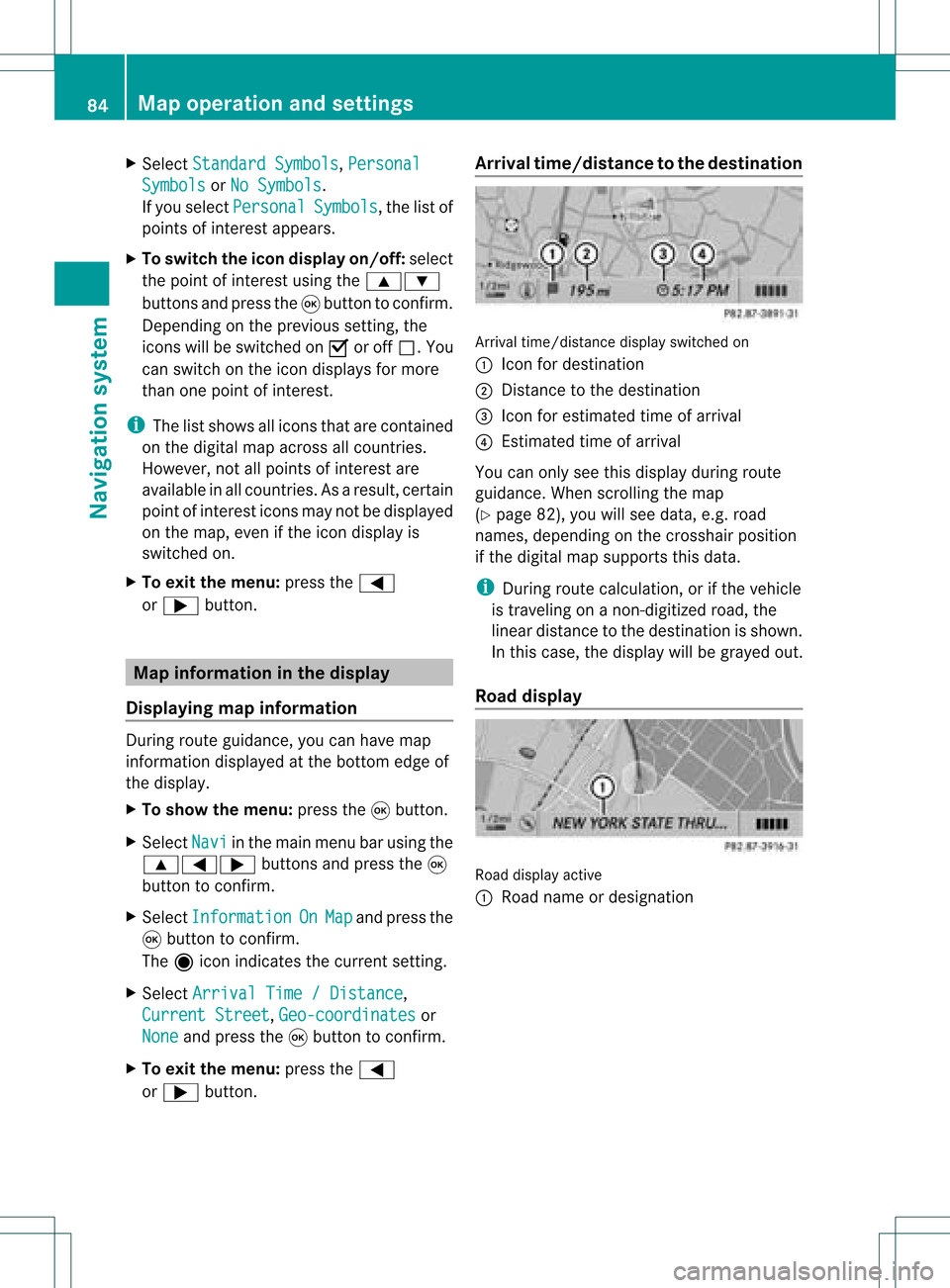
or ; button . Arrival
time/dist ancetothe destinat ion Arrival
time/dist ancedisplay switched on
: Icon fordestination
; Distan cetothe destination
= Icon forestimated timeofarrival
? Estimated timeofarrival
You canonly seethis display duringroute
guidance. Whenscrolling themap
(Y page 82),youwillsee data, e.g.road
names, depending onthe crosshair position
if the digital mapsupports thisdata.
i During routecalculation, orifthe vehicle
is traveling onanon- digitized road,the
linear distance tothe destination isshown.
In this case, thedisplay willbegrayed out.
Road display Road
display active
: Road name ordesignation 84
Map
operat ionand settingsNavigation system
Page 87 of 214
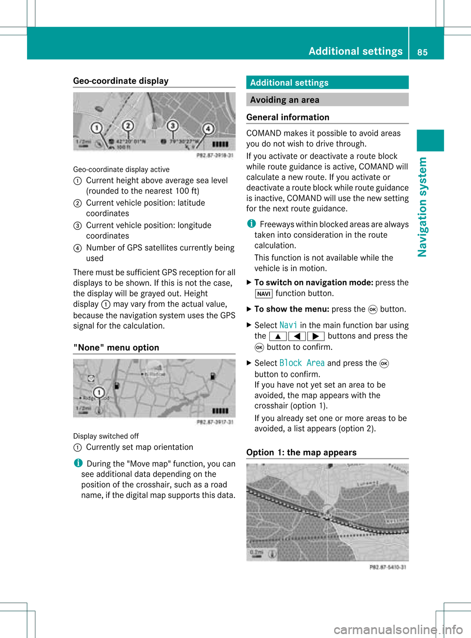
Geo-c
oordinate display Geo-coord
inatedisplayactive
: Current heightabo veavera gesea level
(rou nded tothe nearest 100ft)
; Current vehicle position: latitude
coordina tes
= Current vehicle position: longitu de
coordina tes
? Numbe rofG PS satellites currentlybeing
used
There mustbesufficient GPSrecept ionforall
displays tobe shown. Ifthis isnot thecase,
the display willbegrayed out.Height
display :may varyfrom theactual value,
because thenavigation systemusestheGPS
signal forthe calculation.
"None" menuoption Display
switched off
: Currently setmap orient ation
i During the"Move map"function,youcan
see additional datadepending onthe
position ofthe crosshair, suchasaroad
name, ifthe digital mapsupports thisdata. Additional
settings Avoiding
anarea
General information COMAND
makesitpossible toavoid areas
you donot wish todrive through.
If you activat eor deactivat earoute block
while route guidance isactive, COMAND will
calculate anew route. Ifyou activat eor
deactivat earoute block whileroute guidance
is inact ive,COMAND willuse thenew setting
for the next route guidance.
i Freeways withinblocked areasarealway s
taken intocons ideration inthe route
calculation.
This funct ionisnot availabl ewhile the
vehicle isin motion .
X To switch onnavigation mode:pressthe
Ø functionbutton .
X To show themenu: pressthe9button .
X Select Navi in
the main functionbar using
the 9=; buttonsand press the
9 button toconf irm.
X Select Block Area and
press the9
button toconf irm.
If you have notyetsetanarea tobe
avoided, themap appears withthe
crosshair (option1).
If you already setone ormore areas tobe
avoided, alist appears (option2).
Option 1:the map appears Addit
ional settings
85Navigation system Z
Page 88 of 214
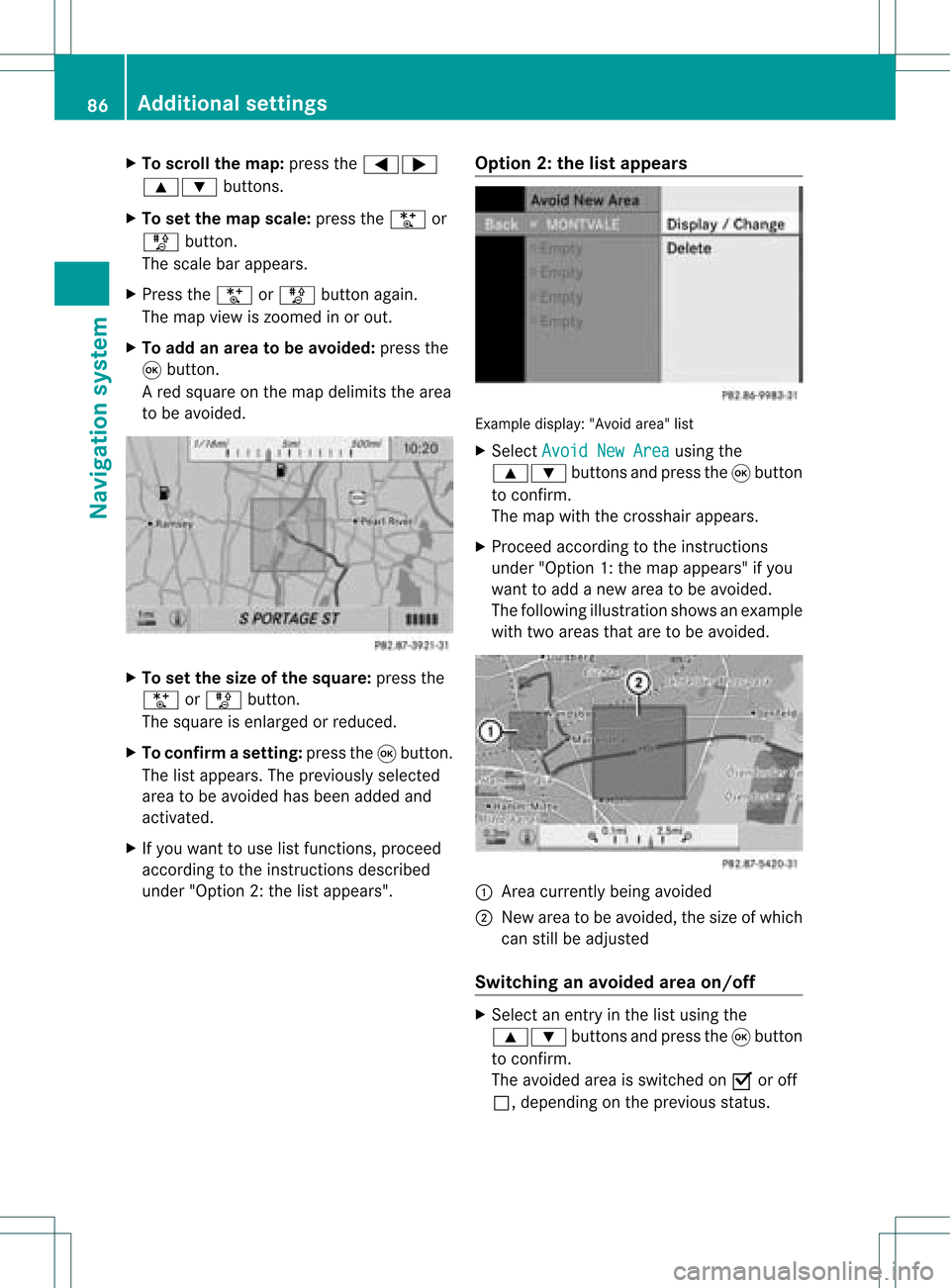
X
To scrol lthe map: pressthe =;
9: buttons.
X To setthe map scale :pre ssthe U or
T button.
The scaleba ra ppears.
X Press theU orT buttonagain.
The map view iszoom edinor out.
X To add anarea tobe avoided :press the
9 butt on.
Ar ed square onthe map delimits thearea
to be avoided. X
To set the size ofthe squa re:press the
U orT button .
The square isenlarged orreduced.
X To confirm asett ing: pressth e9 butt on.
The listappears .The previously selected
area tobe avoided hasbeen added and
activated.
X Ifyou want touse listfunct ions, proceed
according tothe instruct ionsdescribed
under "Option 2:the listappea rs". Option
2:the listappears Example
display:"Avoi dare a"list
X Sel ect AvoidNew Area us
ing the
9: buttons andpressthe 9button
to confi rm.
The map with the cros shairap pe ars .
X Pro cee dacco rding tothe instr uctions
und er"Opti on 1:the map appe ars "if yo u
wa ntto addanew areato be avo ided .
The followi ng illu stra tions hows anexample
with twoareas thataretobe avoided. :
Area current lybeing avoided
; New areatobe avoided, thesize ofwhich
can stillbeadjusted
Switching anavoided areaon/o ff X
Select anentr yin the listusing the
9: buttonsandpress the9button
to confirm .
The avoided areaisswitched onO oroff
ª, depending onthe previous status. 86
Additional
settingsNavigationsystem
Page 90 of 214
X
Sel ect Off -road Rou
te Mem
ory and
press
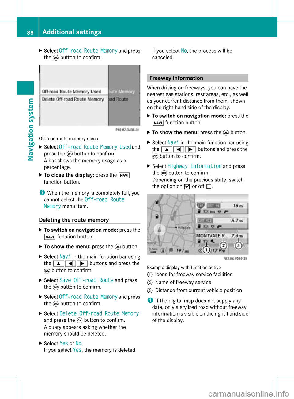
the 9button toconfi rm. Off-ro
adrou tememo rymenu
X Sel ect Off -road Rou
te Mem
ory Use
d and
pre ssthe 9button toconfi rm.
Ab arsho wsthemem oryusage asa
perc entag e.
X To close thedis pla y:pres sth eß
fun ction button.
i When themem oryisco mple tely full, you
can notselec tth eOff -roadRoute Mem
ory men
uite m.
Deleti ngtherou temem ory X
To swit chon nav igat ionmod e:pres sth e
Ø function button.
X To show themen u:pres sth e9 button.
X Sel ect Navi in
themain function bar usin g
th e9=; buttons and pres sth e
9 buttonto confirm .
X Sel ect SaveOff -roadRoute and
pres s
th e9 buttonto confirm .
X Sel ect Off -road Rou
te Mem
ory and
pres s
th e9 buttonto confirm .
X Sel ect Delete Off-roadRouteMemory and
pres sth e9 buttonto confirm .
Aq uery appear sask ing whet herthe
mem oryshould bedelet ed.
X Se lec tYes or
No .
If you selectYes ,
th emem oryisdelet ed. If
you selectNo ,
th epro ces swill be
can celed. Free
way information
When drivingonfreeways, youcan have the
ne ares tgas statio ns,res tareas, etc.,aswel l
as you rcurr entd istanc efrom them, shown
on the right-hand sideofthe disp lay.
X To swi tch onnavig ation mode: pressthe
Ø function button.
X To show themenu: pressthe9button.
X Select Navi in
the main function barusing
the 9=; buttonsandpress the
9 button toconfirm.
X Select Highway Information and
press
the 9button toconfirm.
Dependi ngon the previ ousstate, switch
the option onO oroff ª. Example
displaywith function active
: Icons forfreew ayservice facilities
; Name offreew ayservice
= Distance fromcurrent vehicleposi tion
i Ifthe digitalmap does notsupplyany
data ,only astyli zed road witho utfreew ay
informati onisvisib leon the right-hand side
of the disp lay. 88
Additio
nalsetting sNavigatio nsystem