low NISSAN GT-R 2017 R35 Multi Function Display Repair Manual
[x] Cancel search | Manufacturer: NISSAN, Model Year: 2017, Model line: GT-R, Model: NISSAN GT-R 2017 R35Pages: 248, PDF Size: 1.72 MB
Page 140 of 248
![NISSAN GT-R 2017 R35 Multi Function Display Repair Manual 6. Navigation
Available settings
Setting itemAction
[New Destination] Sets the new destination.
“Setting new destination” (page 6-35)
[Cancel Route] Cancels the current route guidance.
[Route Info](/img/5/524/w960_524-139.png "NISSAN GT-R 2017 R35 Multi Function Display Repair Manual 6. Navigation
Available settings
Setting itemAction
[New Destination] Sets the new destination.
“Setting new destination” (page 6-35)
[Cancel Route] Cancels the current route guidance.
[Route Info")
6. Navigation
Available settings
Setting itemAction
[New Destination] Sets the new destination.
“Setting new destination” (page 6-35)
[Cancel Route] Cancels the current route guidance.
[Route Info] [Turn List] Displays the details of the suggested route.
[Simulation] Simulates the route guidance. This function provides a detailed image of the
route with voice guidance.
“Confirming route” (page 6-35)
[Store Route] A calculated route can be stored. A route can be stored only when it includes at
least one waypoint.
[Map Scroll] A map scrolled further will be displayed.
[Edit/Add to Route] A destination or waypoint can be edited to a route that has already been set.
“Editing route” (page 6-36)
[Settings] [Guidance Settings] [Guidance Voice] Activates or deactivates voice guidance.
[Guidance Volume] Adjust the volume level of voice guidance.
[Traffic Announcement]* Activates or deactivates the traffic information announcements.
[Route Settings] [Basic Route Type] Set the route search conditions.
“Route Settings” (page 6-41)
[Other Routing Choices]
[Show Destination] [Move Location] Displays a map screen and allows the location of the destination to be adjusted.
[Nearby POIs] Search for points of interest near the current vehicle location, such as
restaurants and gas stations, etc. The location can be set as a waypoint.
[Save Location] Save the destination in the Address Book.
[Recalculate] Manually search for the route again after changing the search conditions, etc.
and have the system calculate a route.
“Recalculating route” (page 6-38)
6-34
Page 141 of 248
![NISSAN GT-R 2017 R35 Multi Function Display Repair Manual [Traffic Detour]*Set the route search condition to detour traffic jam and traffic accident.“Searching for detour route using traffic information” (page 6-38)
[Detour] A detour of a specified dista](/img/5/524/w960_524-140.png "NISSAN GT-R 2017 R35 Multi Function Display Repair Manual [Traffic Detour]*Set the route search condition to detour traffic jam and traffic accident.“Searching for detour route using traffic information” (page 6-38)
[Detour] A detour of a specified dista")
[Traffic Detour]*Set the route search condition to detour traffic jam and traffic accident.“Searching for detour route using traffic information” (page 6-38)
[Detour] A detour of a specified distance can be calculated.
“Setting detour route” (page 6-39)
*: A SiriusXM Travel Link or SiriusXM Traffic subscription is necessary to receive SXM information services.
SETTING NEW DESTINATION
When the destination is already set, new
destination can be set.
1. Touch [Navi] on the Launch Bar.
2. Touch [New Destination].
3. Touch the preferred destination setting
method.
“Setting destination” (page 6-14)
INFO:
You can also set a waypoint with this operation.
CANCELING ROUTE
It is possible to delete a destination and all
waypoints that have already been set.
1. Touch [Navi] on the Launch Bar.
2. Touch [Cancel Route].
3. A confirmation message is displayed. Touch [Yes] to delete the currently set destinations
and waypoints.
INFO:
The deleted destination and waypoints cannot
be reactivated.
CONFIRMING ROUTE
The route information can be confirmed and the
suggested route simulation can be performed.
1. Touch [Navi] on the Launch Bar.
2. Touch [Route Info].
3. Touch the preferred item. Available items
. [Turn List]:
Displays the details of the suggested route
guidance.
. [Simulation]:
Simulate the route guidance. This function
provides a detailed image of the route with
voice guidance.
Touch the following keys for operation.
: Pauses the simulation.
: Resumes the simulation.
: Ends the simulation.
. [Store Route]:
A calculated route can be stored. A maximum
of 5 routes can be stored. The stored routes
can easily be recalled for future use.
. [Map Scroll]:
Displays a map screen where the location of
the destination can be confirmed.
6. Navigation
6-35
Page 142 of 248
![NISSAN GT-R 2017 R35 Multi Function Display Repair Manual 6. Navigation
EDITING ROUTE
1. Touch [Navi] on the Launch Bar.
2. Touch [Edit/Add to Route].
3. Edit the following settings and touch [Cal-culate].
Available settings
*1[Add Destination]:
Touch to add](/img/5/524/w960_524-141.png "NISSAN GT-R 2017 R35 Multi Function Display Repair Manual 6. Navigation
EDITING ROUTE
1. Touch [Navi] on the Launch Bar.
2. Touch [Edit/Add to Route].
3. Edit the following settings and touch [Cal-culate].
Available settings
*1[Add Destination]:
Touch to add")
6. Navigation
EDITING ROUTE
1. Touch [Navi] on the Launch Bar.
2. Touch [Edit/Add to Route].
3. Edit the following settings and touch [Cal-culate].
Available settings
*1[Add Destination]:
Touch to add a new destination.
*2Current destination:
Touch to edit or delete the destination.
“Editing/deleting destination or way-
point” (page 6-37)
*3Condition for calculating a route to the
destination/waypoint:
Changes the conditions for route calcula-
tion.
“Changing route calculation condi-
tions” (page 6-37)
*4[Add Waypoint]:
Touch to add a waypoint.
“Setting destination or waypoint”
(page 6-36)
*5Current waypoint:
Modifies or deletes the waypoint.
“Editing/deleting destination or way-
point” (page 6-37)
*6[Calculate]:
After editing the route, the system recalcu-
lates a route with new conditions.
Setting destination or waypoint
A destination or waypoint can be added to a
route that has already been set. Up to 5
waypoints besides one destination can be set.
1. Touch [Navi] on the Launch Bar.
2. Touch [Edit/Add to Route].
3. Touch [Add Destination] or [Add Waypoint].
INFO:
If [Add Destination] is selected, the current
destination changes to a waypoint.
4. Set a destination or waypoint. The method of searching for a destination or waypoint is the
same as the one for a destination.
“Setting destination” (page 6-14)
5. Touch [Add to Route] to add the location to the route.
6. The route information with the selected location added to the route is displayed.
Adjust the route calculation conditions as
necessary.
“Changing route calculation condi-
tions” (page 6-37)
7. Touch [Calculate] to confirm the route change. The route will be recalculated.
INFO:
. The prior route will be deleted automatically.
. Destinations or waypoints can also be added
from the Map Menu.
“Scrolled location map screen”
(page 6-14)
6-36
Page 148 of 248
![NISSAN GT-R 2017 R35 Multi Function Display Repair Manual 6. Navigation
[Use Learned Routes]Uses the roads that are most frequently traveled with the help of
self-learning technology.
[Use HOV Lanes] Uses the HOV lanes.
[Auto Reroute] If the vehicle deviates](/img/5/524/w960_524-147.png "NISSAN GT-R 2017 R35 Multi Function Display Repair Manual 6. Navigation
[Use Learned Routes]Uses the roads that are most frequently traveled with the help of
self-learning technology.
[Use HOV Lanes] Uses the HOV lanes.
[Auto Reroute] If the vehicle deviates")
6. Navigation
[Use Learned Routes]Uses the roads that are most frequently traveled with the help of
self-learning technology.
[Use HOV Lanes] Uses the HOV lanes.
[Auto Reroute] If the vehicle deviates from the suggested route, the system
automatically recalculates a route that leads the vehicle to the
suggested route.
INFO:
. If the vehicle greatly deviates from the suggested route, the system calculates a new route.
. Traffic jam information displayed on the map screen is not statistical traffic information.
. If [Do Not Use Restriction Info] is selected for [Time Restricted Rd] setting, the system calculates a route without any consideration of the regulations
concerning the time or day of the week. Therefore, the suggested route may include a road subject to traffic regulations concerning the time or day of the
week. When driving along the route, always follow all traffic regulations regardless of whether [Time Restricted Rd] is set to be considered or not.
. Even when [Use Real Time Traffic Information] is turned on, if traffic information has not been provided for the area, a detour may not always be indicated
in a location where a traffic jam occurs.
. The system calculates to reduce the time required for the entire route from the start to the destination. If there are no appropriate routes, the system may
lead to a route where a traffic jam occurs instead of leading to a detour.
. The system may not lead to a detour if traffic closure or a traffic jam occurs far from the present location.
6-42
Page 149 of 248
VIEWING TRAFFIC INFORMA-
TION
SiriusXM Traffic information is a subscription
service offered by SiriusXM Satellite Radio.
This service provides real-time information re-
garding traffic flow, accidents, road construction
and other incidents, where available.
SiriusXM Traffic combines information from
commercial and public traffic data providers
including government departments of transpor-
tation, police, emergency services, road sensors,
cameras and aircraft reports. The traffic informa-
tion is broadcast to the vehicle by the SiriusXM
satellites. Available traffic information on the
route the driver selected is shown on the
navigation screen so traffic conditions between
you and the destination are known. Three types
of real-time traffic information for major roadways
are shown on the navigation system:
* Unscheduled traffic data for example, accidents
and disabled vehicles.
* Scheduled traffic data, for example road
construction and road closures.
* Traffic flow information (rate of speed data) .
WARNING
SiriusXM Traffic information is not a
substitute for attentive driving. Traffic
conditions change constantly and emer-
gency situations can arise without warn-
ing. Relying only on SiriusXM Traffic
information may lead to a collision and
could result in serious personal injury.
NOTE:
. Flow information is provided only for
roads equipped with traffic sensors and
is not available in all markets covered
by the service. Flow data may not be
available on portions of a road that is
under construction.
. A SiriusXM Traffic subscription is ne-
cessary to view Traffic Info.
“SiriusXM Travel Link” (page 5-20)
VIEWING AVAILABLE TRAFFIC IN-
FORMATION
Viewing traffic events from list
1. Touch [Info] on the Launch Bar.
2. Touch [SXM Traffic]. A list of available types
of information are displayed.
Available
items Function
[Info on
Route] Displays a list of traffic information
found on the route from the current
vehicle location to the destination.
Available only when a route is set.
[Nearby
Traffic Info] Displays a list of available traffic
information around the current ve-
hicle location.
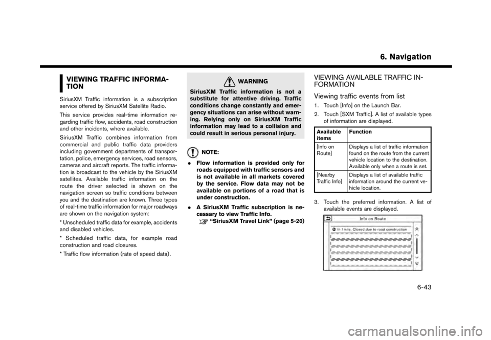
3. Touch the preferred information. A list of
available events are displayed.
6. Navigation
6-43
Page 150 of 248
6. Navigation
4. Touch a preferred events from the list tocheck the detailed information and the map.
Displaying urgent traffic information
When an urgent event is found around the
current vehicle location, a message pops up
automatically on the touch screen display with a
voice announcement.
The message includes the icon, event type, event
information and the direct distance from the
current location to the event.
INFO:
. Urgent traffic information is displayed re-
gardless of whether [Use Traffic Info] func-
tion is on or off.
“Traffic information setting”
(page 6-45)
. When there are multiple urgent events, the
event with the shortest direct distance from
the current location is displayed.
. If the urgent event is on the recommended
route, and if a detour is found, the detour
route notification screen is displayed when
the vehicle approaches the detour point.
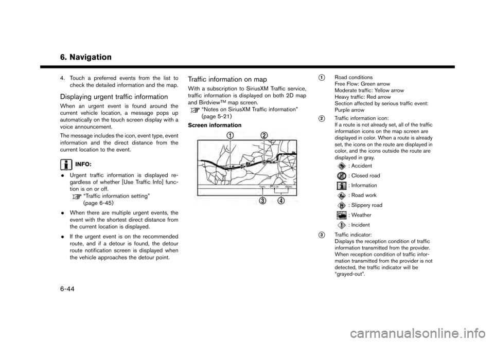
Traffic information on map
With a subscription to SiriusXM Traffic service,
traffic information is displayed on both 2D map
and Birdview
TMmap screen.“Notes on SiriusXM Traffic information”
(page 5-21)
Screen information
*1Road conditions
Free Flow: Green arrow
Moderate traffic: Yellow arrow
Heavy traffic: Red arrow
Section affected by serious traffic event:
Purple arrow
*2Traffic information icon:
If a route is not already set, all of the traffic
information icons on the map screen are
displayed in color. When a route is already
set, the icons on the route are displayed in
color, and the icons outside the route are
displayed in gray.
: Accident
: Closed road
: Information
: Road work
: Slippery road
: Weather
: Incident
*3Traffic indicator:
Displays the reception condition of traffic
information transmitted from the provider.
When reception condition of traffic infor-
mation transmitted from the provider is not
detected, the traffic indicator will be
“grayed-out”.
6-44
Page 151 of 248
*4Remaining distance and estimated time to
the destination calculated with considera-
tion of traffic information on route.
INFO:
Traffic icons are displayed in the scale level of
1/64 miles (25 m) - 5 miles (10 km) range. Some
traffic icons are displayed only on the map at
higher detail levels.
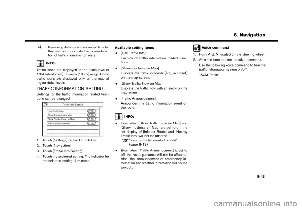
TRAFFIC INFORMATION SETTING
Settings for the traffic information related func-
tions can be changed.
1. Touch [Settings] on the Launch Bar.
2. Touch [Navigation].
3. Touch [Traffic Info Setting].
4. Touch the preferred setting. The indicator for the selected setting illuminates. Available setting items
. [Use Traffic Info]:
Enables all traffic information related func-
tions.
. [Show Incidents on Map]:
Displays the traffic incidents (e.g., accident)
on the map screen.
. [Show Traffic Flow on Map]:
Displays the traffic flow with an arrow on the
map screen.
. [Traffic Announcement]:
Announces the traffic information event on
the route.
INFO:
. Even when [Show Traffic Flow on Map] and
[Show Incidents on Map] are set to off, the
list display of [Info on Route] and [Nearby
Traffic Info] will not be affected.
“Viewing traffic events from list”
(page 6-43)
. Even when [Traffic Announcement] is set to
off, the route guidance will not be affected.
Also, the announcement of emergency in-
formation and weather information will not be
turned off.
Voice command
1. Push <
>located on the steering wheel.
2. After the tone sounds, speak a command. Use the following voice command to turn the
traffic information system on/off:
“SXM Traffic”
6. Navigation
6-45
Page 153 of 248
![NISSAN GT-R 2017 R35 Multi Function Display Repair Manual INFO:
. When the location is stored in the Stored
Locations, [Address Book] can be used to
search for the location.
“Searching from address book”
(page 6-21)
. When 200 locations are already store](/img/5/524/w960_524-152.png "NISSAN GT-R 2017 R35 Multi Function Display Repair Manual INFO:
. When the location is stored in the Stored
Locations, [Address Book] can be used to
search for the location.
“Searching from address book”
(page 6-21)
. When 200 locations are already store")
INFO:
. When the location is stored in the Stored
Locations, [Address Book] can be used to
search for the location.
“Searching from address book”
(page 6-21)
. When 200 locations are already stored, a
new location cannot be stored until a
currently stored location is deleted.
Storing location by moving map
1. Move to the preferred location on the map
and touch [] on the touch screen display.
2. Touch [Save Location]. A message is dis-played.
3. The icon representing the stored location is displayed on the map. Push
Page 156 of 248
![NISSAN GT-R 2017 R35 Multi Function Display Repair Manual 6. Navigation
[Voicetag]Registers a voicetag for the entry which allows the entry to be
used with the voice recognition system.
[Icon] Selects an icon for the entry.
[Sound] Sets the type of the alarm](/img/5/524/w960_524-155.png "NISSAN GT-R 2017 R35 Multi Function Display Repair Manual 6. Navigation
[Voicetag]Registers a voicetag for the entry which allows the entry to be
used with the voice recognition system.
[Icon] Selects an icon for the entry.
[Sound] Sets the type of the alarm")
6. Navigation
[Voicetag]Registers a voicetag for the entry which allows the entry to be
used with the voice recognition system.
[Icon] Selects an icon for the entry.
[Sound] Sets the type of the alarm that sounds when the vehicle
approaches the location.
[Direction] Sets the alarm to sound when approaching from a specific
direction.
[Distance] Sets the alarm to sound when reaching a specific distance to
the location.
[Phone No.] Registers a phone number of the location.
[Group] Registers a group of the entry.
[Entry Number] Registers an entry number for the location.
[Move Location] Adjusts the stored location information.
[Delete] Deletes the stored location information.
[OK] Confirms and saves the edited stored location information.
*: When home location has not been stored, [Home Location (None)] is displayed and a home location can be stored from the menu.
6-50
Page 163 of 248
GENERAL INFORMATION FOR
NAVIGATION SYSTEM
CURRENT VEHICLE LOCATION
Display of current vehicle location
This navigation system combines the data
obtained from the vehicle (by gyro sensor) and
from GPS (Global Positioning System) satellites
to calculate the current location of the vehicle.
This position is then displayed throughout route
guidance to a destination.
What is GPS (Global Positioning Sys-
tem)?
GPS is a position detecting system that uses
satellites deployed by the U.S. government. This
navigation system receives radio signals from
three or more different satellites that orbit
13,049 miles (21,000 km) above the earth in
space, and detect the position of the vehicle by
utilizing the principle of triangulation.
Positioning adjustment:
When the system judges that the vehicle position
is not accurate based on vehicle speed and gyro
sensor data calculations, the system will auto-
matically adjust the position of the vehicle icon
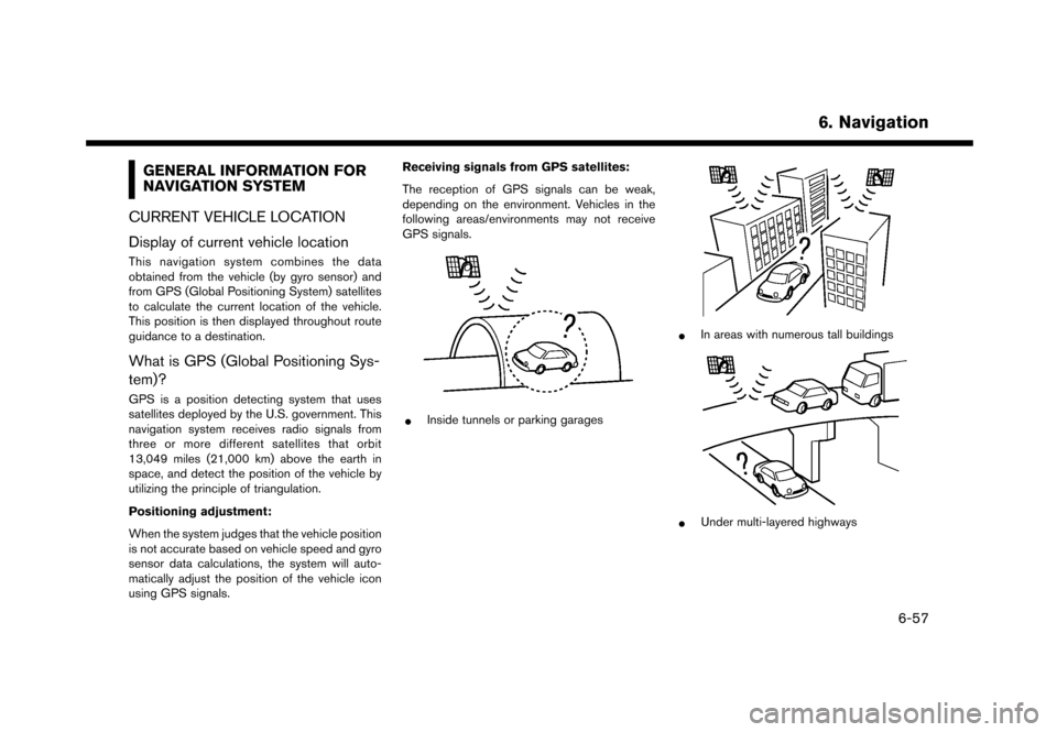
using GPS signals. Receiving signals from GPS satellites:
The reception of GPS signals can be weak,
depending on the environment. Vehicles in the
following areas/environments may not receive
GPS signals.
*Inside tunnels or parking garages
*In areas with numerous tall buildings
*Under multi-layered highways
6. Navigation
6-57