display TOYOTA tC 2016 Accessories, Audio & Navigation (in English)
[x] Cancel search | Manufacturer: TOYOTA, Model Year: 2016, Model line: tC, Model: TOYOTA tC 2016Pages: 164, PDF Size: 6.21 MB
Page 129 of 164
3. DESTINATION SEARCH 3. DESTINATION SEARCH
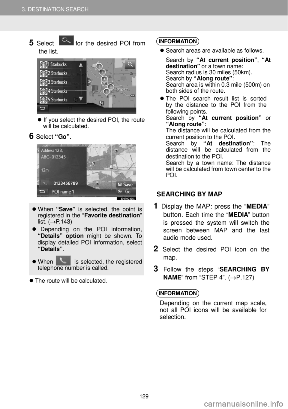
5 Select for the desired PO I from
t h e list.
If yo u se lec t th e d esire d P O I, th e rou te
w ill be ca lcu la ted.
6 Select “Go” .
W hen “ Sa ve” is s e le cte d, th e poi nt is
reg is tered in th e “ Fa vori te de stina tio n”
l ist. (→ P.1 43 )
Dep end in g on t he PO I in formati on,
“De ta ils ” option might be shown. To
di spl ay det aile d P OI in fo rmat io n, selec t
“De ta ils” .
W hen is se lec ted, th e re gi stered
t e leph on e numb er is c al led.
T he ro ute wi ll be c a lc ula ted.
INFORM ATION
S earc h areas ar e av ail able a s fo llows.
S earc h b y “ At cu rre nt p osit io n” , “ At
d estination ” o r a tow n nam e:
S earc h rad iu s is 3 0 m ile s (50 km) .
S earc h b y “Al ong ro ute ”:
S earc h area is w it h in 0. 3 mi le (50 0m ) on
bo th s ides o f th e rout e.
T he PO I se arc h res ult lis t is sorted
by t he d is tan ce to the P O I fro m th e
f o llow in g poin ts .
S earc h by “A t c urrent p osit io n” or
“Al on g ro ute ”:
T he d is tan ce w ill b e ca lcu lat ed fro m the
curren t pos it io n to th e POI .
S earc h by “A t destinati on ”: The
d is ta nc e wi ll be ca lcu la te d from th e
d es tina tio n t o th e PO I.
S earc h b y a tow n n ame : T he dis ta nce
wi ll be ca lcu lat ed fr om t ow n cen te r t o t he
PO I.
SEAR CHING BY MAP
1 Display th e MAP: press the “MED IA”
button.
Each time the “M EDIA ” button
is pressed the system will switch the
scre en be tween MAP and th e last
audio mode us ed.
2 Se lect th e desired POI ic on on the
map.
3 F ollow the step s “SEARC HING BY
N AME ” from “STEP 4”. ( →P.1 27)
INFORM ATION
Depend ing on th e current m ap scale,
n ot a ll POI icons w ill be a va ila ble for
selection.
129
Page 130 of 164
3. DESTINATION SEARCH 3. DESTINATION SEARCH
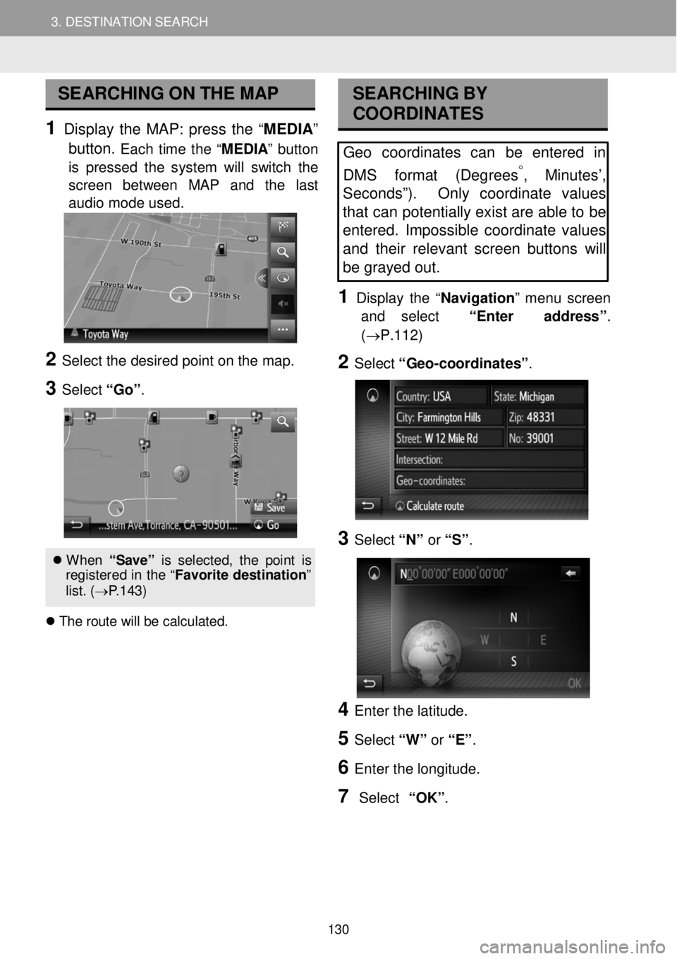
SEARCHING ON THE MAP
1 Display the MAP: press the “ME DIA ”
button.
Each time the “M EDIA ” button
is pressed the system will switch the
scre en bet ween MAP and the last
audio mode us ed.
2 Se lect the de sired po int o n t he m ap.
3 Select “Go ”.
When “S ave ” is s el ect ed, th e p oin t is
re gis tere d in th e “F avori te d est ina tion ”
l is t. ( → P.143)
T he r o ute w ill b e cal cul ate d.
SEA RCHING BY
COORDI NATES
Geo coordinates can be entered in
DMS f ormat (Degrees
°, Minutes’,
Sec onds”). Only coordinate values
tha t can potentially exist are able to be
entered . Impossible coordinate values
and their relevant screen buttons will
be gray ed out .
1 D is p lay the “Navigati on ” me nu screen
and select “Enter address ”.
(→P.112)
2 Select “G eo -coordinat es” .
3 Select “N” or “S” .
4 Enter th e latitude.
5 Select “W” or “E” .
6 Enter t he lo ngitud e.
7 Select “OK”.
130
Page 132 of 164
4. ROUTE GUIDANCE
1. STARTING ROUTE GUIDANCE
4. ROUTE GUIDANCE
STA RTING ROUTE
GUIDA NCE SCR EEN
After searching the destination, the
s ta rting route guidance screen will be
displ ayed.
According to the setting, either the
recommended route screen or route
alter native s screen will be displayed.
( →P.133 )
W ARNING
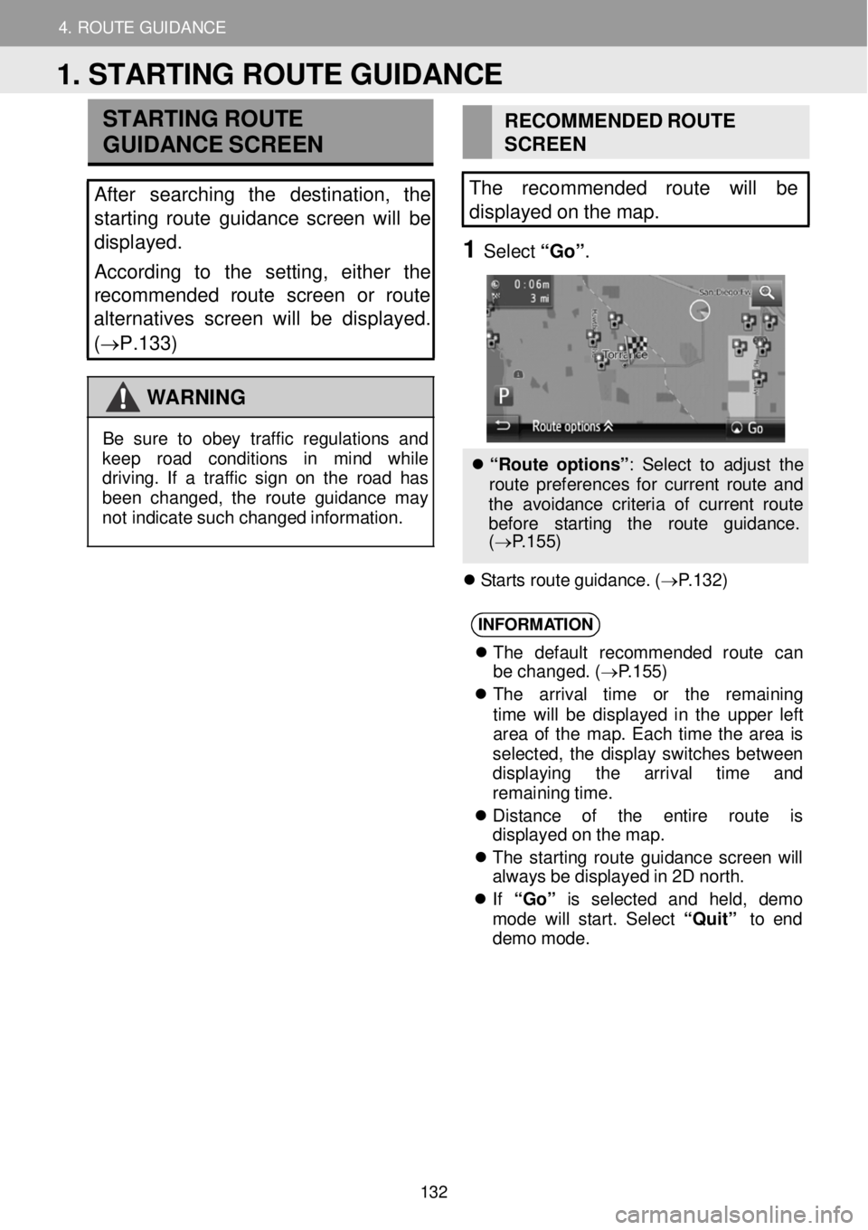
RECO MME NDED ROU TE
SCRE EN
The recomme nded route will be
displayed on the map.
1 Select “Go ”.
B e su re to ob ey tr a ff ic regu lations and
kee p road co ndi tion s in mi nd whi le
dr ivin g. If a tr aff ic s ig n o n th e roa d h as
been chang ed, th e route g uid anc e ma y
not ind icate su ch c hang ed in formati on.
“ R oute o pt io ns”: S elec t to a d ju st th e
r o ute p re fe re nces f or c u rrent ro ute a nd
t h e av oid anc e cri teri a o f cu rre nt rou te
b efor e star tin g th e ro ute guid ance.
( → P.1 55 )
S tar ts r o ut e g uid ance . ( → P.1 32 )
INFORM ATION
T he defa ult rec ommend ed rou te ca n
be cha nged . ( → P.1 55)
T he arri va l tim e or th e rema ini ng
t ime wi ll be dis play ed in th e upper lef t
area of t he map . Eac h tim e th e area is
se lec ted, th e dis pla y sw itc hes be twee n
d isp lay ing t he arriva l tim e and
remai nin g t ime.
Dis tan ce of th e entir e rou te is
d is pla yed o n t h e map.
T he s ta rti n g rou te gu idan ce scre en w ill
a lw ays b e di spl aye d in 2 D nor th.
If “Go” is selec te d and held , demo
mod e will start . Se lec t “Q uit” to end
dem o mo de.
1. STARTING ROUTE GUIDANCE
132
Page 133 of 164
4. ROUTE GUIDANCE
1. STARTING ROUTE GUIDANCE
4. ROUTE GUIDANCE
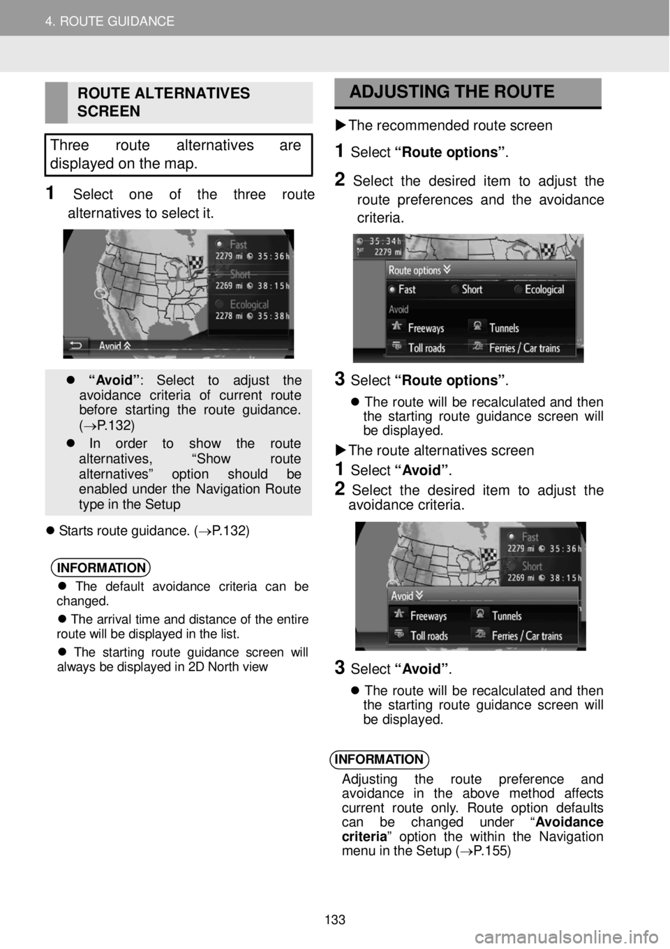
ROUTE ALTER NATIVES
SCREEN
Three route alternatives are
d isplayed on the map.
1 Select one of the th re e route
alter natives to select it.
“A vo id” : Sele ct to ad just th e
avoi dance crit eri a of curren t ro ut e
b ef ore st ar tin g t he rou te gu ida nce .
( → P.1 32 )
In orde r to sho w th e route
al terna tives, “Sho w ro ut e
a lt ernat iv es ” option sh ou ld be
en abl ed un der th e Navi gatio n Rou te
ty pe in th e S etu p
S ta rts r o ute g uid ance. ( → P.1 32 )
INFORM
ATION
The default avoidance criteria can be
changed.
The arrival time and distance of the entire
route will be displayed in the list.
The starting route guidance screen will
always be displayed in 2D North view
ADJU
STI NG THE
ROUTE
The r eco mme nded r oute scre en
1 Select “Route o ption s” .
2 Se le ct the desir ed item to adj ust the
ro ute pr efer en ces and the avoi dance
criteri a.
3 Select “Route o ption s” .
Th e ro ute w ill b e rec alc ula te d a n d the n
t he s tar tin g ro ut e g ui danc e scre en w ill
b e d is p la yed.
The route alter natives scre en
1 Select “A voi d”.
2 Select the d esired it em to a djust th e
avoi dance criteria.
3 Select “A voi d”.
T he rou te wi ll be re ca lcu la te d an d th e n
t he s tart in g rou te gu idan ce scree n wi ll
b e d is p layed.
INFORM ATION
Ad jus tin g th e rou te pref eren ce an d
avoi dance in the ab ove met hod aff ec ts
curren t ro ute onl y. Rou te op tio n de fau lt s
ca n be change d unde r “A vo id anc e
c rit er ia ” op tio n the w it h in t he Nav iga tion
men u in th e Set up ( → P.1 55)
133
Page 134 of 164

4. ROUTE GUIDANCE
1. STARTING ROUTE GUIDANCE
4. ROUTE GUIDANCE
No. Information
Distance and arriv al or remaining time t o the destin atio n
Each time in format ion box is se lected, the screen will change betw een ar rival time and remaining time to the desti nation.
Guidance ro ute
Select to switch bet ween full scr een
map view and split map screen view. Sideba r is only shown on full scr een ma p view.
The name of the current str eet or t he next str eet (when approaching a
maneuver point)
Current position
Distance to the next turn with the
arrow indicating the turn di rection. Select to repeat the last navigation announcement.
ROUTE GUIDANCE SCREEN SIGNPOSTS
When approaching the turn, a sig npost
W hile guiding the route, the route
guidance screen will be disp la ye d. will
automatically be displayed.
INTERST ATE JUNCTION SCREEN
When approaching an in terstate
j unc tion, junction view images will
automat ically be displ aye d.
T U NNEL JUNC TION SC REEN
When
approaching a tunnel junction ,
tunnel junction view images will
automatically be displayed.
2. ROUTE GUIDANCE
134
Page 135 of 164
4. ROUTE GUIDANCE
1. STARTING ROUTE GUIDANCE
4. ROUTE GUIDANCE
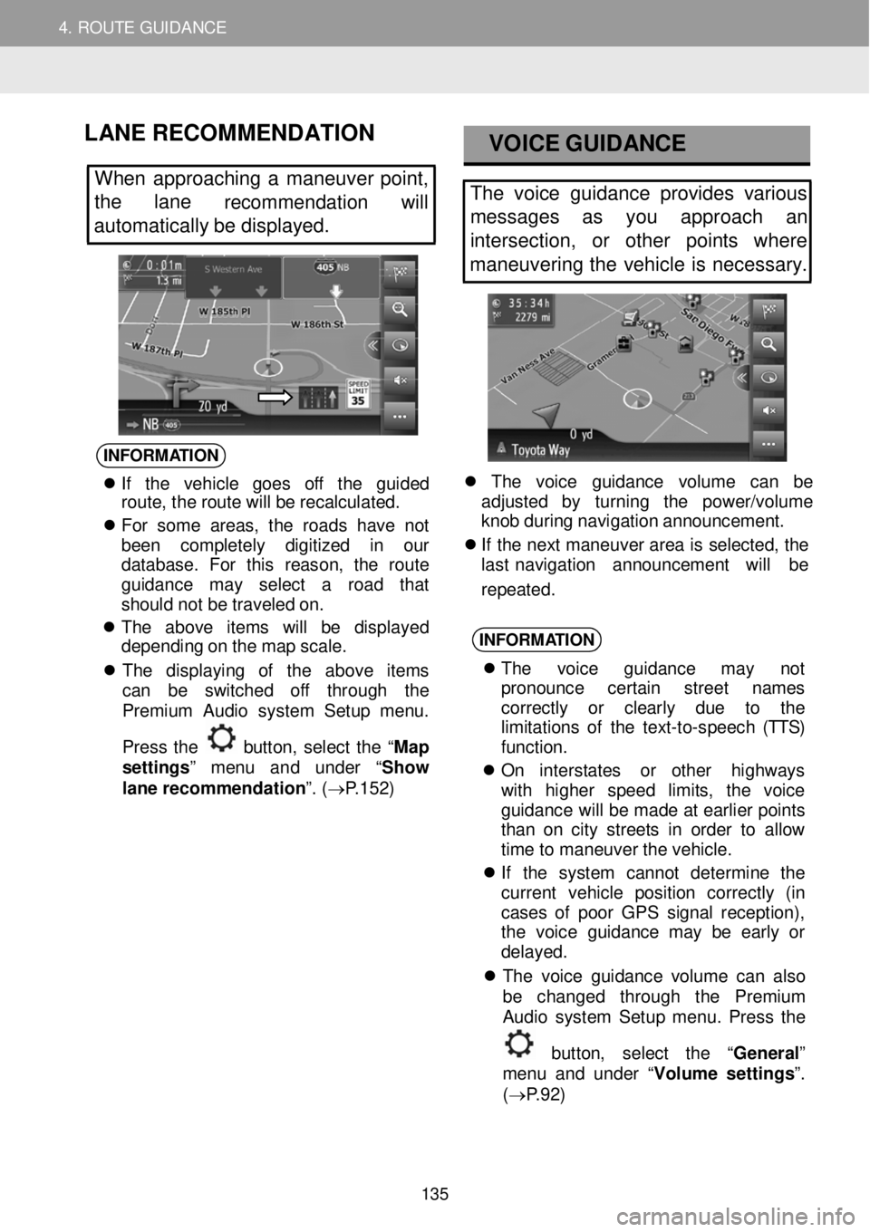
LANE RE COMMENDATION
When approa ching a maneuver point,
the lane
recommendation will
automatically be displayed.
VOICE G UIDANCE
The voice guidance provides various
messages as you approach an
intersection, or other points where
maneuvering the vehicle is necessary.
INFORM ATION
If th e vehi cle goe s off th e gui ded
rou te, th e ro ute wi ll be rec alc ula ted.
Fo r som e area s, t he road s have not
bee n compl etel y digi tize d in our
da tabase . F or th is re ason, th e rou te
gu idance ma y se lec t a roa d tha t
s hould not be tra vel ed o n.
Th e abov e ite m s will be disp layed
depe ndin g o n t h e map sca le.
Th e dis pla yin g of th e abov e it em s
ca n be swi tche d off th roug h the
Pr emiu m Aud io system S etu p menu .
Pres s th e
but to n, se lec t the “Ma p
s et tings ” men u and under “ Show
lane recommendation ”. ( → P.15 2)
Th e vo ic e guida nce vo lum e can be
a d ju ste d by turni ng th e power /vo lume
kn ob duri ng navi gatio n a nnou ncem ent.
If th e n e xt ma neuv er a re a is s e le cte d, the
l as t nav iga tio n ann ounc ement w ill be
repeated.
INFORM ATION
T he voice guidanc e may not
p ro noun ce cer tai n stree t nam es
correc tly or clear ly due to th e
l im ita tions of th e te xt -to -spee ch (TTS)
f u nc tio n.
O n in ters ta te s or oth er hig hw ays
wi th higher sp ee d l imit s , th e voi ce
gu ida nce wi ll be ma de a t e arl ie r p oi nt s
t ha n o n c ity str e ets in o rd er to a llo w
t im e to ma neuve r t h e vehi cle.
If th e syst em can not de termine th e
curren t veh icl e pos it io n corre ctly (in
ca ses of poor GP S s ignal recep tion) ,
th e vo ice gui dance ma y be ear ly or
d elay ed.
T he vo ic e gu idan ce vo lum e can a ls o
be chan ged th roug h the Premiu m
Aud io system S etu p menu . Pres s th e
bu tto n, se lec t the “General ”
m en u and under “ Volume settings ”.
( → P.9 2)
135
Page 137 of 164
4. ROUTE GUID ANCE
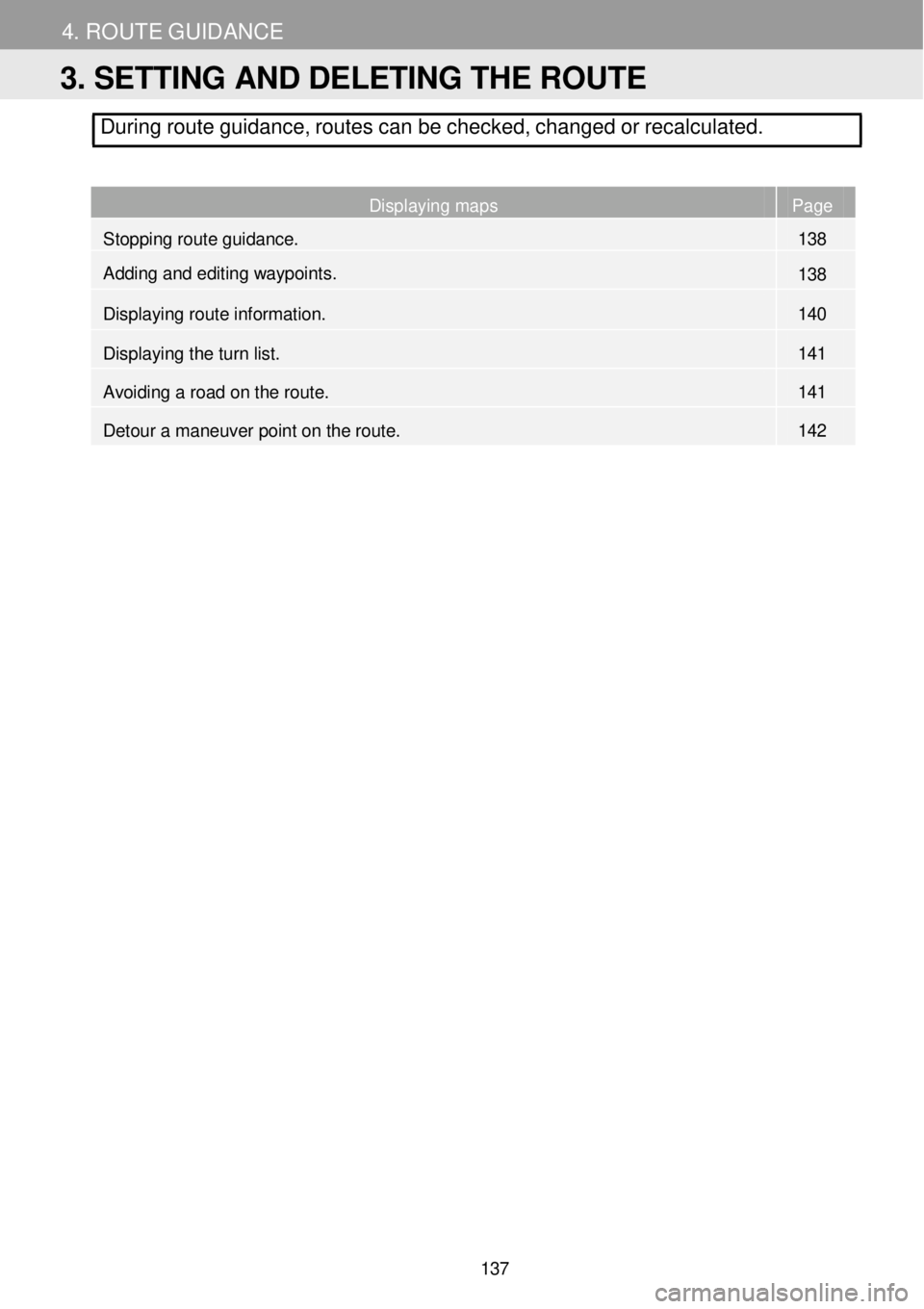
During route guidance, routes can be checked, changed or recalcul ated.
Displaying maps Page
Stopping route guidance. 138
Adding and editing waypoint
s. 138
Displaying route information. 140
Displaying the turn list. 141
Avoiding a road on the route. 141
Detour a maneuver point on the route. 142
3. SETTING AND DELETING THE ROUTE
137
Page 138 of 164
4. ROUTE GUIDANCE 4. ROUTE GUIDANCE
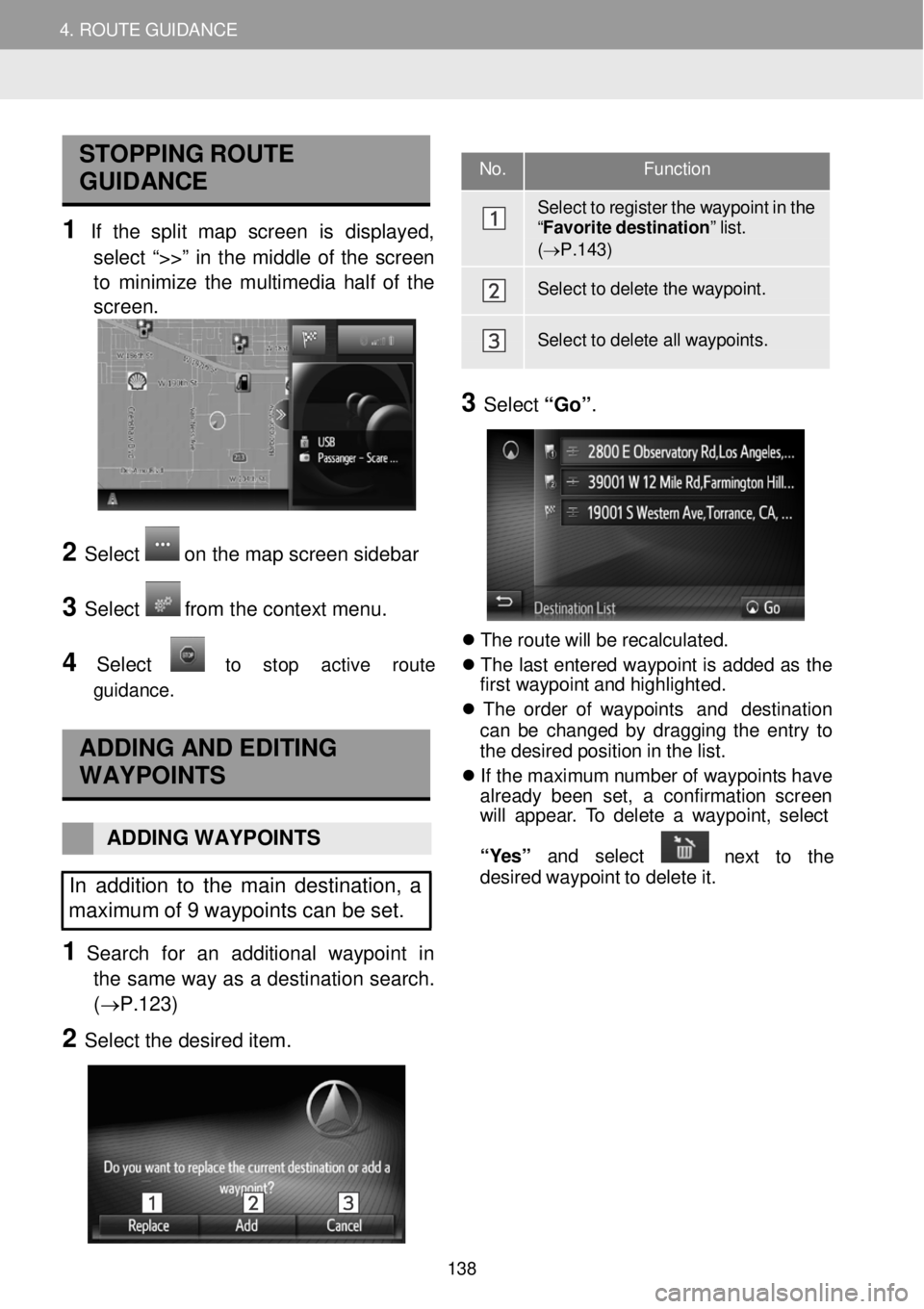
STOPPING ROUTE
GUIDAN CE
1 If the sp lit map scre en is displayed ,
s e lect “>>” in th e midd le of the screen
to m ini mize the multime dia h a lf o f the
scr een.
2 Select on the map screen s ideba r
3 Select from the co nte xt menu.
4 Select to sto p act iv e rou te
g uid ance.
AD DING A ND EDITING
WAYPOINTS
ADDING W AYPOIN TS
In addition to the main desti nati on, a
maximum of 9 waypoints can be set.
1 Search for an additi onal wayp oint in
the same way as a desti na tion s e arch.
(→P.1 23)
2 Select the de sired item.
No.
Function
Sel ect to r egister the waypoint in the “F avo rite destination ” list. (→ P.1 43)
Sel ect to d elete the waypoint.
Select to d elete all waypoints.
3 Select “Go”.
Th e rou te w ill b e recal cula ted.
Th e las t e nt ere d way poi nt is a dde d a s the
f irs t w aypo in t a nd hi ghl igh ted.
Th e orde r of way poi nt s an d des tin ation
c a n b e c h ang ed by drag ging th e en tr y to
t h e d esire d p osi tio n in th e lis t.
If th e m axim um n umber o f w aypoi nts have
a lrea dy b ee n se t, a con firm atio n screen
w ill a ppea r. T o del ete a w aypo in t, se lect
“ Y es” and selec t
nex t to th e
d es ir e d wa ypo in t to de let e it .
138
Page 139 of 164
4. ROUTE GUIDANCE 4. ROUTE GUIDANCE
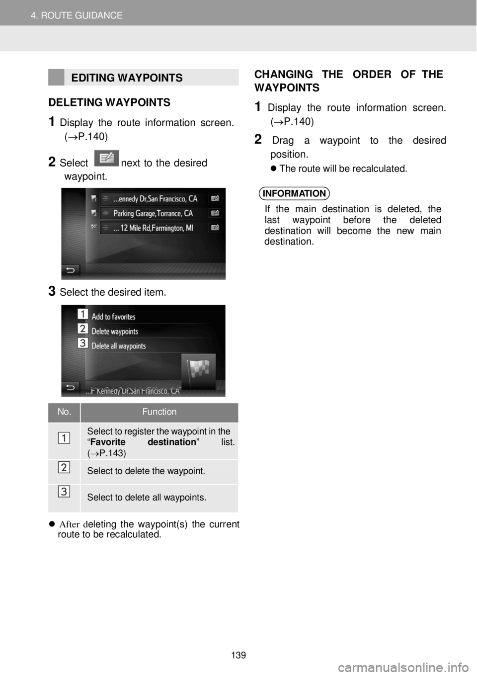
EDITING WAYPOINTS
DELETING W AYPOINTS
1 Display the ro ute in fo rm ation screen.
(→P.1 40)
2 Select next to the desir ed
waypoi nt.
3 Select the desired item.
CH
ANGING THE ORDER OF THE
WAYP OINTS
1 Displ ay the route in formati on scre en .
(→P.1 40)
2 Dra g a wayp oint to the desir ed
p osition.
Th e r o ute w ill b e re ca lcul ate d.
INFORM ATION
If th e mai n des tina tio n is de le ted , the
l a st wayp oi nt bef ore the del eted
de stinat io n w ill becom e the new ma in
de stinat ion.
No. Function
Sel ect to r egister the waypoint in the “F avo rite destination ” list. (→P.143)
Select to d elete the waypoint.
Select to d elete all waypoints.
After del etin g t he waypo in t(s ) t he current
r o ute to b e recal cula ted.
139
Page 141 of 164
4. ROUTE GUIDANCE 4. ROUTE GUIDANCE
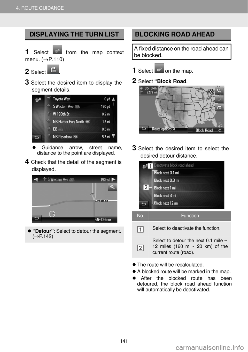
No. Function
Select to dea ctiva te the functi on.
Select to deto ur the next 0 .1 mile ~ 12 miles (160 m ~ 20 km) of the current r oute (road).
DISPLAYING T H E TURN LIST
1 Select from the map context
menu . (→P.110)
2 Select .
3 Select th e d esired item to displ ay th e
segment details .
BLOCKING RO AD AHEAD
A fixed distance on the road ahead can
be blocked.
1 Select o n th e m ap.
2 Select “Block Ro ad .
Gui danc e arrow , stree t name ,
d is tanc e to th e po in t ar e d isp laye d.
4 Check tha t the detail of th e seg ment is
displ ayed.
“Detour ”: Se lec t to de tou r t h e s egment.
( → P.142)
3 Select the de sired item to sel ect the
d esired de to ur distance.
Th e r o ute w ill b e re ca lcul ate d.
A b lock ed r o ut e wi ll be mark ed in th e ma p.
Afte r t he block ed ro ut e has been
d eto ure d, t he b loc k ro ad a head fun ction
wi ll autom atica lly b e d e ac tiv ate d.
141