display TOYOTA tC 2016 Accessories, Audio & Navigation (in English)
[x] Cancel search | Manufacturer: TOYOTA, Model Year: 2016, Model line: tC, Model: TOYOTA tC 2016Pages: 164, PDF Size: 6.21 MB
Page 142 of 164
4. ROUTE GUIDANCE 4. ROUTE GUIDANCE
DETOU RING A S EGMENT ON
THE ROUTE
DETOURI NG A SEGMENT
FROM THE TURN LIST
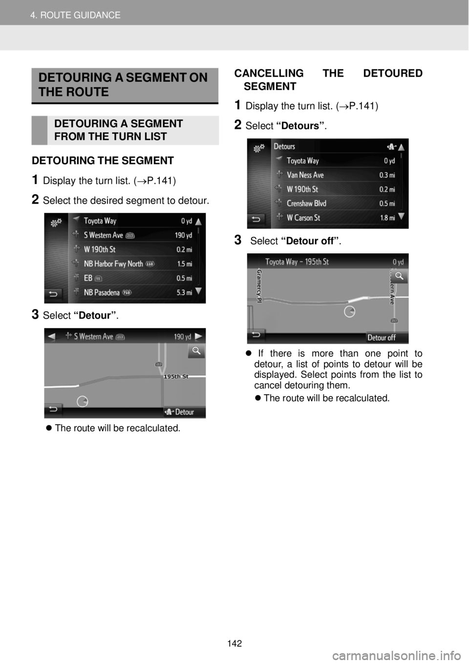
DETO URING THE SEG MENT
1 Display the turn list. (→P.141 )
2 Select t he d esir ed s egm ent to deto ur.
3 Select “Detour” .
T he r o ute w ill b e re cal cul ate d.
CAN CELLI NG T HE D ETO URED
S EGMENT
1 Dis p la y th e tu rn li s t. (→P. 141 )
2 Select “Detours” .
3 Select “Deto ur off ”.
If th ere is mor e tha n on e poin t to
de tou r, a l is t o f poi nts to d eto ur wi ll be
d isp lay ed. Sel ect po in ts fr o m the lis t to
ca ncel det ouri ng t hem.
Th e rou te w ill b e recal cula ted.
142
Page 143 of 164

4. ROUTE GUIDANCE 5. FAVORITE DESTINATIONS
5. FAVORITE DESTINATIONS
REGISTERING A NEW ENTRY
Up to 200 entries can be registered
w ith this system.
REGISTERI NG FR OM THE
“Favor ite destination” LIST
1 Display th e “Nav igation ” m enu scre en
and select
. (→P.1 12)
2 Select “C rea te n ew e ntr y” .
3 En ter th e e ntry a ddress a nd t hen sel ect
“Save new entry” .
4 Enter the entry name and then select
“OK” .
5 C heck t h at the e n try is re gistered in the
“Favorite destination ” list.
Se lec t to dis pla y an d edi t the
e ntr y in format ion . ( → P.1 47)
1. REGISTERING AN ENTRY
143
Page 147 of 164

5. MY DESTINATIONS 5. FAVORITE DESTINATIONS
DISPLAYING AND EDITING
THE ENTRY IN FORMATION
1 Display t he “Nav igation ” menu scree n
and select
to display the “F avo rite
destination” li s t (→P.14 3), the “ Last”
list or “ Phone book ”.
2 Select n ext to t he d esir ed e ntry.
The entry o ptions screen :
INFORM ATION
If an en tr y tha t is tra nsf erre d fr o m a
c e llu la r phon e is edi te d, th e ch ang e w ill
on ly aff ec t th e “Fa vori te des tina tio n”
l ist entr y. ( → P.143)
DISPLAYING DETAILS OF
T H E ENTRY IN FO RM ATION
1 Displ ay t he en try options scre en.
(→P. 147)
2 Select “Sh ow d eta ils ”.
3 C heck the deta ils of the entry
i n formation.
Th e addres s w ill b e marke d o n t h e map.
Th e addr ess an d a p ic ture, if a vai lab le ,
o f th e co ntac t fro m th e system ’s p hon e
b ook wi ll be d isp lay ed.
When “ Go” is selected, the starting
route guidance screen will be displayed.
No. Function Page
Select to display detailed entry information. 147
Select to change the entry name. 148
Select to edit the address. 148
Select to delete the entry. 148
Select to delete all entries. 148
2. DISPLAYING AND EDITING THE ENTRY INFORMATION
147
Page 148 of 164
5. MY DESTINATIONS 5. FAVORITE DESTINATIONS
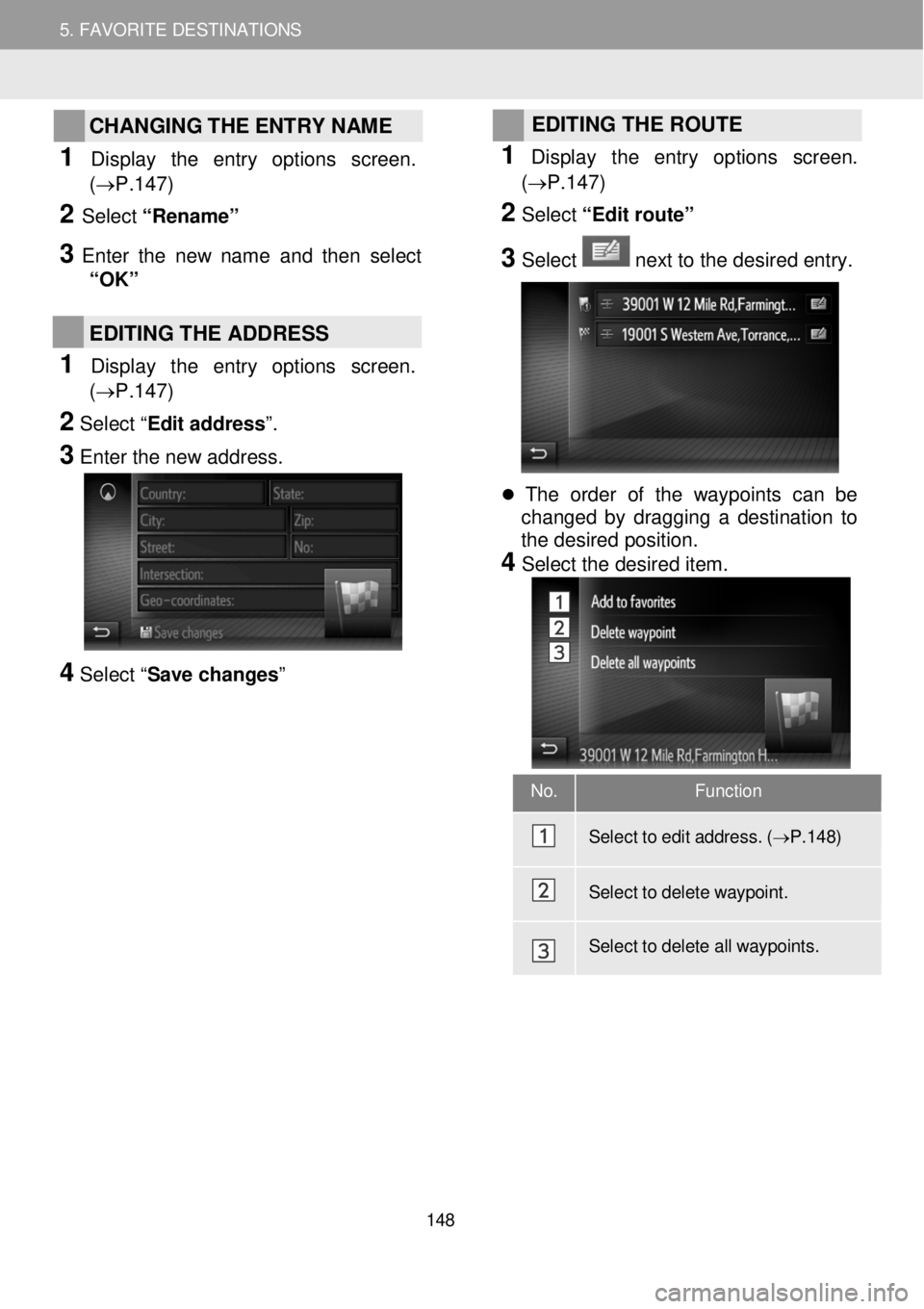
CHANGING THE ENTRY NAME
1 Dis p lay the entry op tions screen.
(→P.1 47)
2 Select “Renam e”
3 Enter the new name and then se le ct
“OK”
EDITING THE ADDRESS
1 Display the entry options screen.
(→P.1 47)
2 Select “ Edit address”.
3
Enter the new address.
4 Select “ Save changes”
EDITING THE ROUTE
1
Dis p lay the entry op tions scre en.
(→P. 147)
2 Select “Edit route”
3 Select next to the desired entry.
The order of the waypoints can be
changed by dragging a destination to
the desired position.
4 Select the desired item.
No. Function
Sel ect to e dit a ddress. ( → P.1 48)
Sel ect to d elet e waypoint.
Select to d elete all waypoints.
148
Page 149 of 164
.5. FAVORITE DESTINATION S
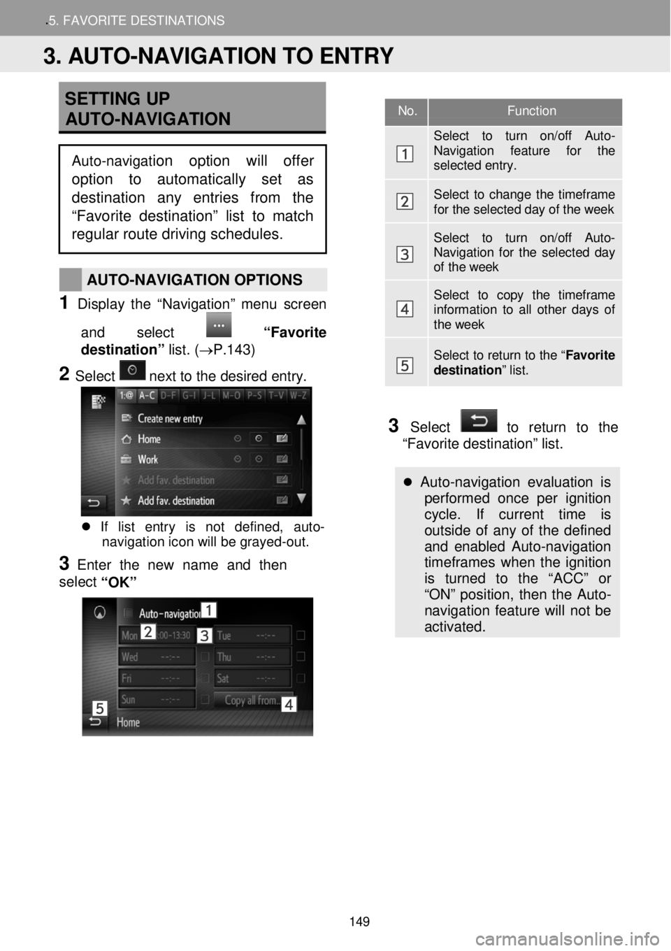
SETTING UP
AUTO -NAVIGATION
AUTO -NAVIGATION OPTIONS
1 Display t he “Nav igation ” menu scree n
and select
“Favo rite
destination” lis t. (→P.14 3)
2 Select n ext to t he d esir ed e ntry.
If list entry is not defined, auto-
navigation icon will be grayed -out.
3 Enter the new name and then
se le ct
“OK”
3 Select to return to the
“Favorite destination” list.
Auto -navigation evaluation is
performed once per ignition
cycle. If current time is
outside of any of the defined
and enabled Auto-navigation
timeframes when the ignition
is turned to the “ACC” or
“ON” position, then the Auto-
navigation feature will not be
activated.
No. Function
Select to turn on/off Auto-Navigation feature for the selected entry.
Select to change the timeframe for the selected day of the week
Select to turn on/off Auto-Navigation for the selected day of the week
Select to copy the timeframe information to all other days of the week
Select to return to the “ Favorite destination” list.
3. AUTO-NAVIGATION TO ENTRY
Auto-navigation option will offer
option to automatically set as
destination any entries from the
“Favorite destination” list to matc h
regular route driving schedules.
149
Page 152 of 164
5. MY DESTINATIONS 6. NAVIGATION SETTING
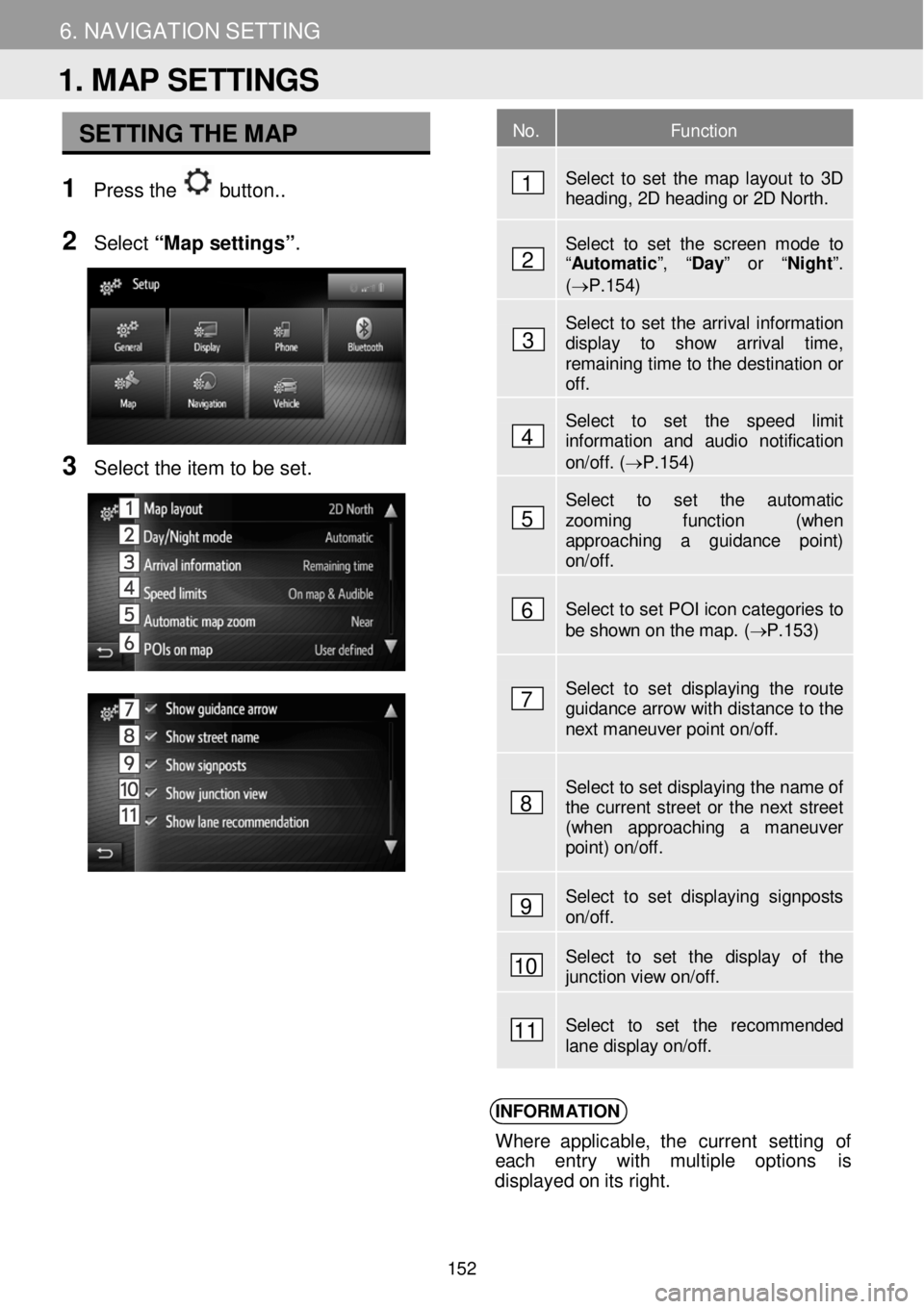
SETTING THE MAP
1 Pre ss the button. .
N
2 Select “Map setting s”.
3 Se lect the item to b e set.
INFORM ATION
Where applicable, t he curren t se ttin g of
e ach entry with multiple op tions is
d ispl aye d o n it s ri ght.
No. Function
Select to set the map layout to 3D heading, 2D heading or 2D North.
Select to set the screen mode to “Automatic ”, “Day” or “Night ”. (→P.154)
Select to set the arrival information display to show arrival time, remaining time to the destination or off.
Select to set the speed limit information and audio notification on/off. (→P.154)
Select to set the automatic zooming function (when approaching a guidance point) on/off.
Select to set POI icon categories to be shown on the map. ( → P.153 )
Select to set displaying the route guidance arrow with distance to the next maneuver point on/off.
Select to set displaying the name of the current street or the next street (when approaching a maneuver point) on/off.
Select to set displaying signposts on/off.
Select to set the display of the junction view on/off.
Select to set the recommended lane display on/off.
1. MAP SETTINGS
1
2
3
4
5
6
7
8
9
10
11
152
Page 153 of 164
6. NAVIGATION SETTING 6. NAVIGATION SETTING
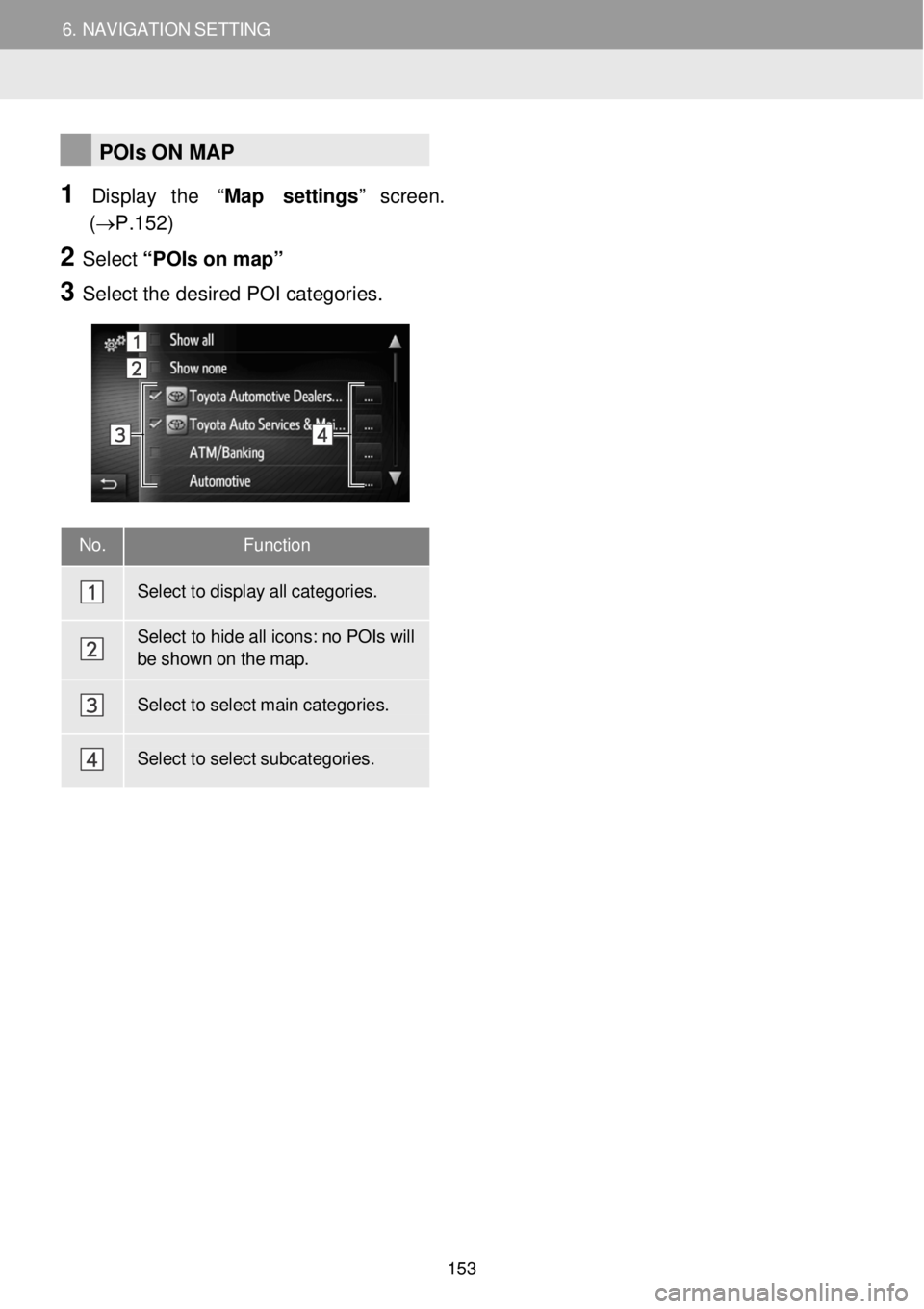
No. Function
Select to display all categor ies.
Select to hide all icons: no POIs will be shown on the map.
Select to select main categor ies.
Select to select subcategor ies.
POIs ON MAP
1 Display the “Map settings ” screen.
(→P.15 2)
2 Select “PO Is on m ap”
3 Se lect the de sired POI categor ie s.
153
Page 154 of 164
6. NAVIGATION SETTING 6. NAVIGATION SETTING
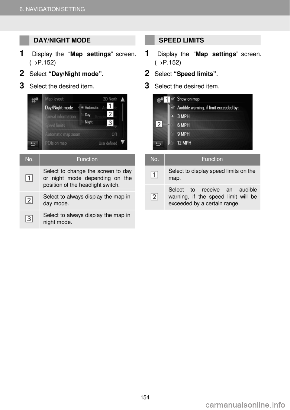
No. Function
Select to display speed limits on the
map.
Select to re ceive an audible
warning, if the speed limit w ill be exceede d by a cer tain range.
DAY/ NIGHT MODE
1 Display the “Map settings ” screen.
(→P.15 2)
2 Select “D ay/N ig ht m ode”.
3 Se lect the de sired item.
SPEED LIMITS
1 Display the “Map settings ” screen.
(→P.15 2)
2 Select “S peed limi ts ”.
3 Se le ct the d esired item.
No. Function
Select to change the scre en to day
or ni ght m ode depending on the position of the headlight switch.
Select to always dis play the map in day mode.
Select to always dis play the map in nigh t mode.
154
Page 155 of 164
6. NAVIGATION SETTING
2. ROUTE SETTINGS
6. NAV IGAT IO N SET TING
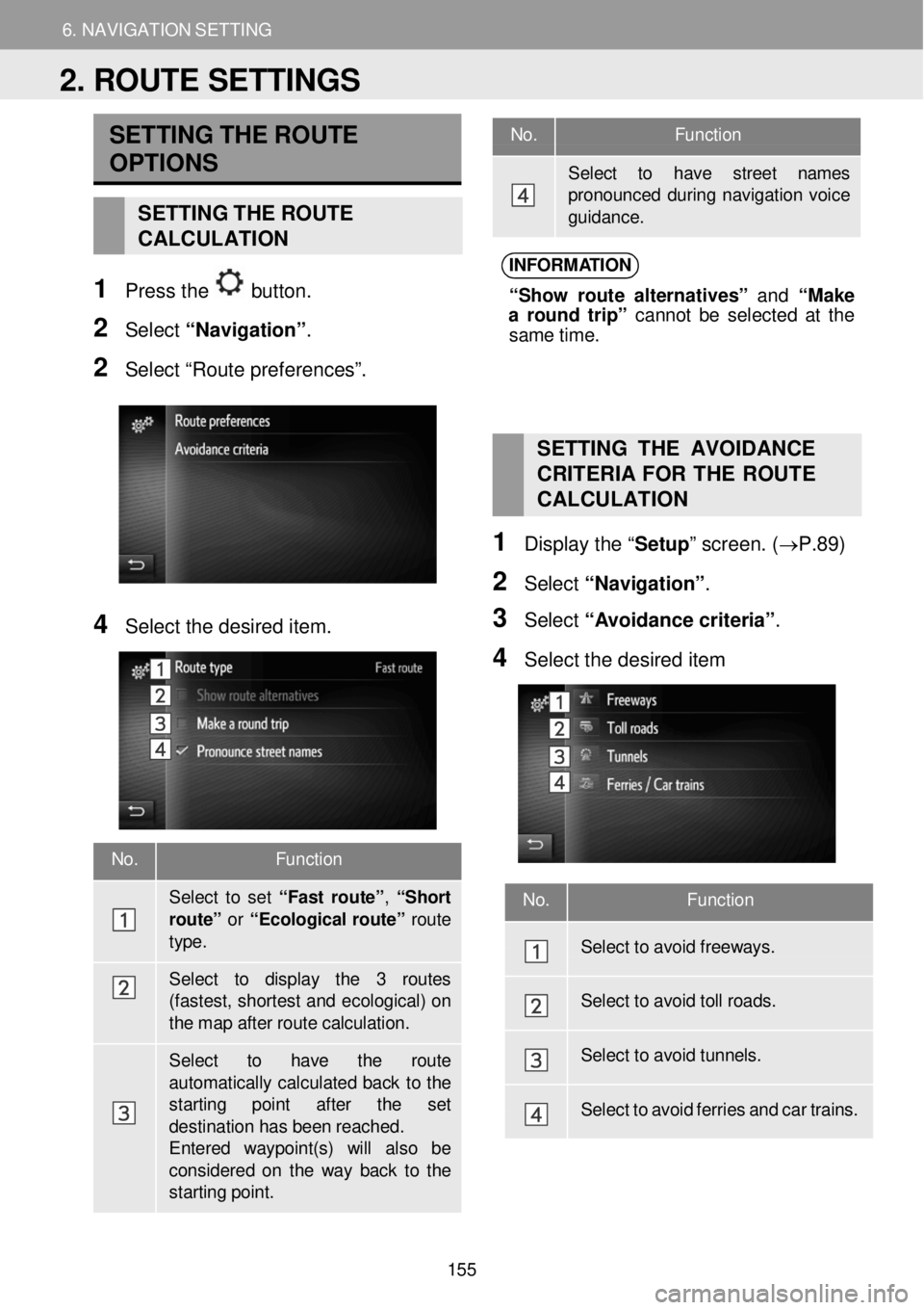
No. Function
Select to have street names pronounced during navigati on voice gui dance.
No. Function
Sel ect to set “ F ast rou te ”, “Sh ort
route” or “Ecol ogical r o ut e” route
type.
Select to display the 3 routes (fastest, shor test and ecological) on the map after route calculation.
Select to have th e route
automatically calculated back to the starting point after the set destinati on has been reached. Entered waypoint(s) will also be consider ed on the way back to the starting point.
SETTING THE ROUTE
OPTIONS
SETTING THE ROUTE
CALCULATION
1 Pr ess the button.
2 Select “N avig ati o n”.
2 Se lect “Route preferences”.
INFORM ATION
“S ho w ro ute a lt e rn ativ es” and “M ake
a ro und trip” c anno t b e s e lec te d at the
sam e t im e.
4 Select the desired item.
SETTING THE AVOIDANCE
C RITERIA FOR THE ROUTE
C AL CULATION
1 Displ ay the “ Setup” screen. ( →P.89)
2 Select “Navi gati on”.
3 Select “ A voi dance criteria” .
4 Se lect the de sired item
No. Function
Select to avoid freeways.
Select to avoid toll r oads.
Select to avoid tunnels.
Select to avoid ferrie s and car trains.
2. ROUTE SETTINGS
155
Page 156 of 164
7. NAVIGATION SYSTEM INFORMATION
1. LIMITATIONS OF THE NAVIGATION SYSTEM
7. NAVIGATION SYSTEM INFORMATION
This navigation system calculates the
c u rrent vehicle position using satellite
s ignals, various vehicle signals, map
data, etc. However, an accurate
positi on may not be shown depending
on sa tellite condition, road
configuration, ve hicle condition or
other c irc umstances.
The Globa l Pos iti o n in g System (GPS)
d eve lope d and operated by th e U.S.
Dep art m ent of D efe nse provides an
a ccurate c urre nt vehic le pos it io n, normal ly
using 4 or more sa te llites, a nd in some
case 3 sat ellites. The GPS system h a s a
certa in le ve l o f inaccuracy. W hile the
navi gation system will compe nsa te for this
m ost of th e time, occasio nal positio ning
errors of up to
1 00 m (3 00 feet) can and sh ould be
ex pected. Gene rally, p osit ion errors w ill
b e c orre cted w ith in a few second s.
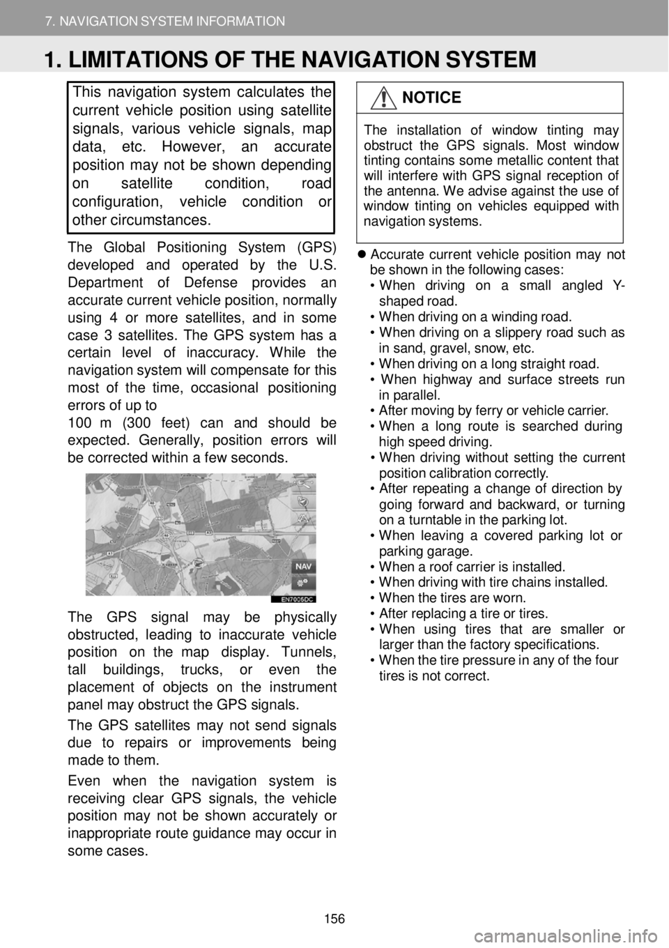
The GPS signa l may be physic ally
o bstructed, l ead ing to in acc u ra te veh icle
p ositi o n on t he map display. Tunne ls,
ta ll bu ildin gs, trucks, or eve n th e
p laceme nt of obje cts on the in str um ent
pan el may obstruct the GPS signals.
T he GPS satel lites may not send sign als
d ue to r epa irs or im pro ve m en ts being
m ade to the m.
Even when the navigation system is
re ce iving clear GPS s ignal s, the v ehicle
p osition m ay not be shown accurately or
i na pprop riate ro ute g u id an ce m ay occ ur in
so me ca se s.
NOTICE
T he in sta lla tio n of windo w tint in g may
obs truc t th e GP S sig nal s. Mos t w indow
t in tin g co ntain s som e me tallic con tent t hat
w ill in terf ere wi th GP S s ign al re cept io n o f
t h e an tenn a. W e a dvi se aga inst t he us e o f
win dow ti ntin g on veh ic les eq uip ped w ith
n av iga tio n s yst ems.
Accurate current v e hi cle po sit io n m ay n ot
b e s h ow n in th e fo llo w in g c a ses:
• When d riv in g o n a sm all a ng le d Y -
shap ed r o ad.
• When dr iv in g o n a w indi ng roa d.
• When drivi ng on a s lipper y ro ad su ch as
i n sa nd, grav el, sno w, e tc.
• When dr iv in g o n a lo ng s tra ight r o ad.
• When highw ay a nd s u rfac e s treet s run
i n p ar all el.
• A ft e r moving by ferry o r veh icle carri er.
• When a lon g ro ute is searc hed dur ing
hi gh s peed dr iv ing .
• When drivi ng w ith out s e ttin g th e c u rre nt
pos it io n ca librat io n c o rre ctly .
• A ft e r re peati ng a chan ge o f d irec tio n by
go in g fo rwar d a nd backward , o r turni ng
o n a turnt able in t h e p a rk in g lo t.
• When le avi ng a c o vere d p ark in g lo t or
p ark in g garag e.
• When a roof carrie r is ins ta lle d.
• When dr iv in g w ith tir e ch ain s ins tal led.
• When t h e t ire s ar e wor n.
• A ft e r repl acin g a tir e o r t ires .
• When u sin g tire s th at ar e sma ller or
large r t han t h e f a ct ory s p ec if ica tio ns.
• When t h e t ir e pr essur e i n a ny o f t h e f our
ti re s is not c o rre ct.
1. LIMITATIONS OF THE NAVIGATION SYSTEM
156