MERCEDES-BENZ SL ROADSTER 2012 Owners Manual
Manufacturer: MERCEDES-BENZ, Model Year: 2012, Model line: SL ROADSTER, Model: MERCEDES-BENZ SL ROADSTER 2012Pages: 637, PDF Size: 20.68 MB
Page 371 of 637
cVd
COMAND controller and press Wto
confirm.
X Select Read traffic messages auto‐
Read traffic messages auto‐
matically
matically and pressWto confirm.
The function is switched on Oor off ª,
depending on the previous status. Destination memory
Home address (My address) Entering the home address via address
entry
X Proceed as described under "Adopting an
address book entry as a home address"
(Y page 368). Confirm My Address
My Address by
pressing W.
X To enter the home address for the first
time: confirm New entry
New entry by pressing W.
X To change the home address: select
Change
Change in the menu showing the home
address by turning cVdthe COMAND con-
troller and press Wto confirm.
X Confirm New entry
New entry by pressing W.
X In both cases, enter the home address as a
destination, e.g. as a town, street and
house number (Y page 327). Then, save the
home address (Y page 330).
Adopting an address book entry as a
home address
X To switch to navigation mode: press the
Ø button.
X To show the menu: pressWthe COMAND
controller.
X Select Destination
Destination in the navigation sys-
tem menu bar by turning cVdthe
COMAND controller and press Wto con-
firm.
X Select From memory
From memory and pressWto con-
firm.
You will see the destination memory list
either with the character bar (option 1) or
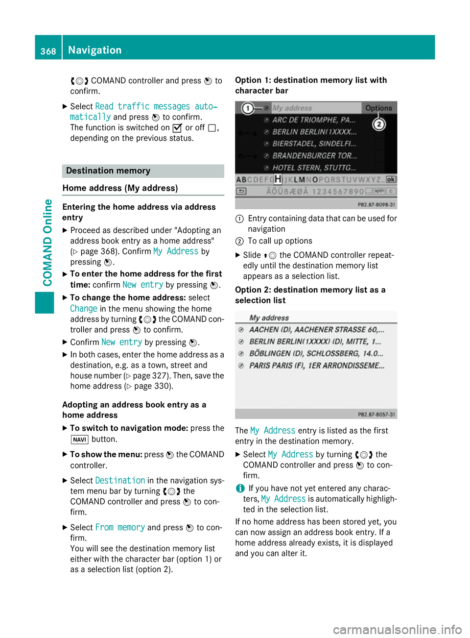
as a selection list (option 2). Option 1: destination memory list with
character bar
:
Entry containing data that can be used for
navigation
; To call up options
X Slide ZVthe COMAND controller repeat-
edly until the destination memory list
appears as a selection list.
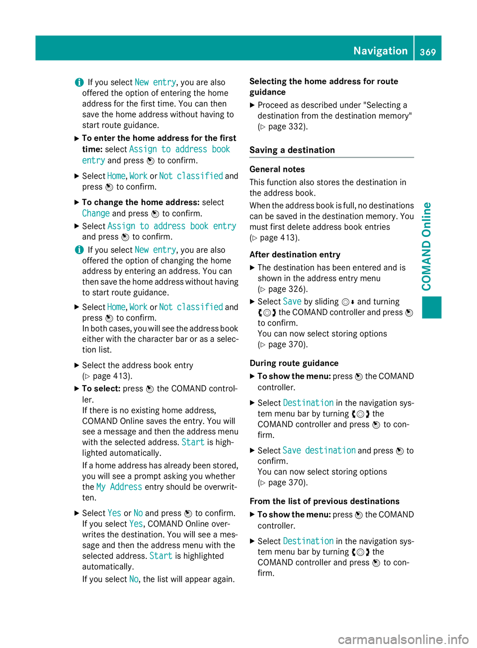
Option 2: destination memory list as a
selection list The
My Address My Address entry is listed as the first
entry in the destination memory.
X Select My Address
My Address by turningcVdthe
COMAND controller and press Wto con-
firm.
i If you have not yet entered any charac-
ters, My MyAddress
Address is automatically highligh-
ted in the selection list.
If no home address has been stored yet, you
can now assign an address book entry. If a
home address already exists, it is displayed
and you can alter it. 368
NavigationCOMAND Online
Page 372 of 637
i
If you select
New entry
New entry, you are also
offered the option of entering the home
address for the first time. You can then
save the home address without having to
start route guidance.
X To enter the home address for the first
time: select Assign to address book
Assign to address book
entry entry and press Wto confirm.
X Select Home
Home,Work
WorkorNot
Not classified
classified and
press Wto confirm.
X To change the home address: select
Change
Change and press Wto confirm.
X Select Assign to address book entry
Assign to address book entry
and press Wto confirm.
i If you select
New entry
New entry, you are also
offered the option of changing the home
address by entering an address. You can
then save the home address without having
to start route guidance.
X Select Home Home,Work
WorkorNot
Not classified
classified and
press Wto confirm.
In both cases, you will see the address book either with the character bar or as a selec-
tion list.
X Select the address book entry
(Y page 413).
X To select: pressWthe COMAND control-
ler.
If there is no existing home address,
COMAND Online saves the entry. You will
see a message and then the address menu
with the selected address. Start
Start is high-
lighted automatically.
If a home address has already been stored,
you will see a prompt asking you whether
the My Address
My Address entry should be overwrit-
ten.
X Select Yes YesorNo
No and press Wto confirm.
If you select Yes
Yes, COMAND Online over-
writes the destination. You will see a mes-
sage and then the address menu with the
selected address. Start Startis highlighted
automatically.
If you select No No, the list will appear again. Selecting the home address for route
guidance
X Proceed as described under "Selecting a
destination from the destination memory"
(Y page 332).
Saving a destination General notes
This function also stores the destination in
the address book.
When the address book is full, no destinations
can be saved in the destination memory. You
must first delete address book entries
(Y page 413).
After destination entry
X The destination has been entered and is
shown in the address entry menu
(Y page 326).
X Select Save Saveby sliding VÆand turning
cVd the COMAND controller and press W
to confirm.
You can now select storing options
(Y page 370).
During route guidance
X To show the menu: pressWthe COMAND
controller.
X Select Destination Destination in the navigation sys-
tem menu bar by turning cVdthe
COMAND controller and press Wto con-
firm.
X Select Save
Savedestination
destination and pressWto
confirm.
You can now select storing options
(Y page 370).
From the list of previous destinations
X To show the menu: pressWthe COMAND
controller.
X Select Destination Destination in the navigation sys-
tem menu bar by turning cVdthe
COMAND controller and press Wto con-
firm. Navigation
369COMAND Online Z
Page 373 of 637
X
Select From last Destinations
From last Destinations and
press Wto confirm.
The list of previous destinations appears.
X Select a destination by turning cVdthe
COMAND controller and press Wto con-
firm.
The destination address is shown.
X Select Save
Save and press Wto confirm.
You can now select storing options
(Y page 370).
Selecting storage options
Once you have chosen one of the following
options for storing a destination, you can
specify storage options: R after destination entry (Y page 369)
R during route guidance (Y page 369)
R from the list of previous destinations
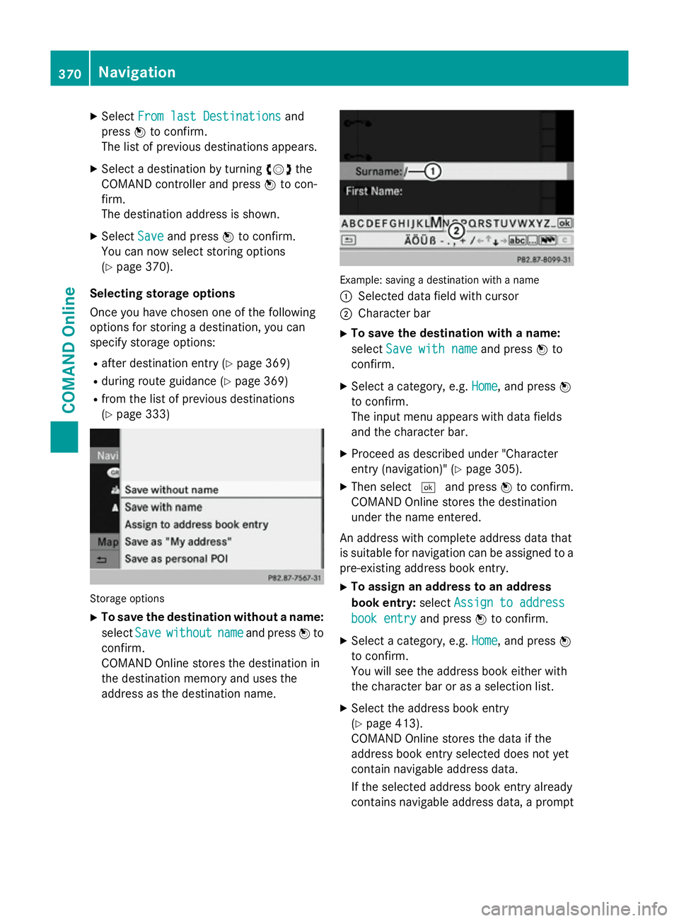
(Y page 333) Storage options
X To save the destination without a name:
select Save
Save without without name
nameand press Wto
confirm.
COMAND Online stores the destination in
the destination memory and uses the
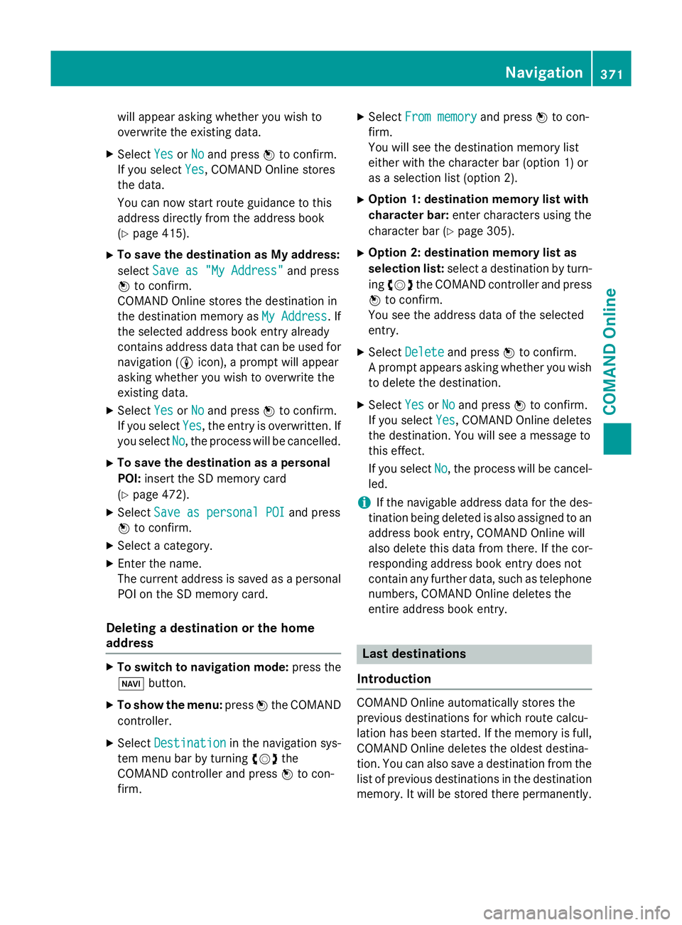
address as the destination name. Example: saving a destination with a name
:
Selected data field with cursor
; Character bar
X To save the destination with a name:
select Save with name Save with name and pressWto
confirm.
X Select a category, e.g. Home Home, and pressW
to confirm.
The input menu appears with data fields
and the character bar.
X Proceed as described under "Character
entry (navigation)" (Y page 305).
X Then select ¬and press Wto confirm.
COMAND Online stores the destination
under the name entered.
An address with complete address data that
is suitable for navigation can be assigned to a pre-existing address book entry.
X To assign an address to an address
book entry: selectAssign to address Assign to address
book entry
book entry and pressWto confirm.
X Select a category, e.g. Home
Home, and pressW
to confirm.
You will see the address book either with
the character bar or as a selection list.
X Select the address book entry
(Y page 413).
COMAND Online stores the data if the
address book entry selected does not yet
contain navigable address data.
If the selected address book entry already
contains navigable address data, a prompt 370
NavigationCOMAND Online
Page 374 of 637
will appear asking whether you wish to
overwrite the existing data.
X Select Yes YesorNo
No and press Wto confirm.
If you select Yes
Yes , COMAND Online stores
the data.
You can now start route guidance to this
address directly from the address book
(Y page 415).
X To save the destination as My address:
select Save as "My Address"
Save as "My Address" and press
W to confirm.
COMAND Online stores the destination in
the destination memory as My Address My Address. If
the selected address book entry already
contains address data that can be used for
navigation (L icon), a prompt will appear
asking whether you wish to overwrite the
existing data.
X Select Yes
Yes orNo No and press Wto confirm.
If you select Yes
Yes , the entry is overwritten. If
you select No
No, the process will be cancelled.
X To save the destination as a personal
POI: insert the SD memory card
(Y page 472).
X Select Save as personal POI
Save as personal POI and press
W to confirm.
X Select a category.
X Enter the name.
The current address is saved as a personal
POI on the SD memory card.
Deleting a destination or the home
address X
To switch to navigation mode: press the
Ø button.
X To show the menu: pressWthe COMAND
controller.
X Select Destination Destination in the navigation sys-
tem menu bar by turning cVdthe
COMAND controller and press Wto con-
firm. X
Select From memory
From memory and pressWto con-
firm.
You will see the destination memory list
either with the character bar (option 1) or
as a selection list (option 2).
X Option 1: destination memory list with
character bar: enter characters using the
character bar (Y page 305).
X Option 2: destination memory list as
selection list: select a destination by turn-
ing cVd the COMAND controller and press
W to confirm.
You see the address data of the selected
entry.
X Select Delete Delete and press Wto confirm.
A prompt appears asking whether you wish to delete the destination.
X Select Yes
YesorNo
No and press Wto confirm.
If you select Yes
Yes, COMAND Online deletes
the destination. You will see a message to
this effect.
If you select No No, the process will be cancel-
led.
i If the navigable address data for the des-
tination being deleted is also assigned to an
address book entry, COMAND Online will
also delete this data from there. If the cor-
responding address book entry does not
contain any further data, such as telephone
numbers, COMAND Online deletes the
entire address book entry. Last destinations
Introduction COMAND Online automatically stores the
previous destinations for which route calcu-
lation has been started. If the memory is full,
COMAND Online deletes the oldest destina-
tion. You can also save a destination from thelist of previous destinations in the destination
memory. It will be stored there permanently. Navigation
371COMAND Online Z
Page 375 of 637
Storing a destination permanently in
the destination memory X
Proceed as described in the "From the list
of previous destinations" section
(Y page 333).
Storing the vehicle position in the list of
previous destinations X
To switch on navigation mode: press the
Ø function button.
X To show the menu: pressWthe COMAND
controller.
X Select Position
Position in the navigation system
menu bar by turning cVdthe COMAND
controller and press Wto confirm.
X Select Save
Save vehicle vehicle position
position and press
W to confirm.
COMAND Online stores the current vehicle position as a destination in the list of pre-
vious destinations.
Storing the crosshair position in the list
of previous destinations A crosshair appears on the map if you have
moved the map manually (Y
page 373). You
can store the crosshair position as a destina-
tion in the list of previous destinations.
X To show the menu: pressWthe COMAND
controller.
X Select Position Position in the navigation system
menu bar by turning cVdthe COMAND
controller and press Wto confirm.
X Select Save crosshair position
Save crosshair position and
press Wto confirm.
Deleting a previous destination X
To switch on navigation mode: press the
Ø function button.
X To show the menu: pressWthe COMAND
controller.
X Select Destination
Destination in the navigation sys-
tem menu bar by turning cVdthe COMAND controller and press
Wto con-
firm.
X Select From last destinations
From last destinations and
press Wto confirm.
The list of previous destinations appears.
X Select the desired destination and press W
to confirm.
The destination address appears.
X Select Delete Delete and press Wto confirm.
A prompt appears asking whether the entry
should be deleted.
X Select Yes
YesorNo
No and press Wto confirm.
If you select Yes
Yes, the entry is deleted.
If you select No
No, the process will be cancel-
led. Map operation and map settings
General notes Company logos displayed on the map are
trademarks of the respective companies and
used solely for the purpose of indicating the
locations of these companies. The use of such logos on the map does not indicate approval
of, support of or advertising by these compa-
nies for the navigation system itself.
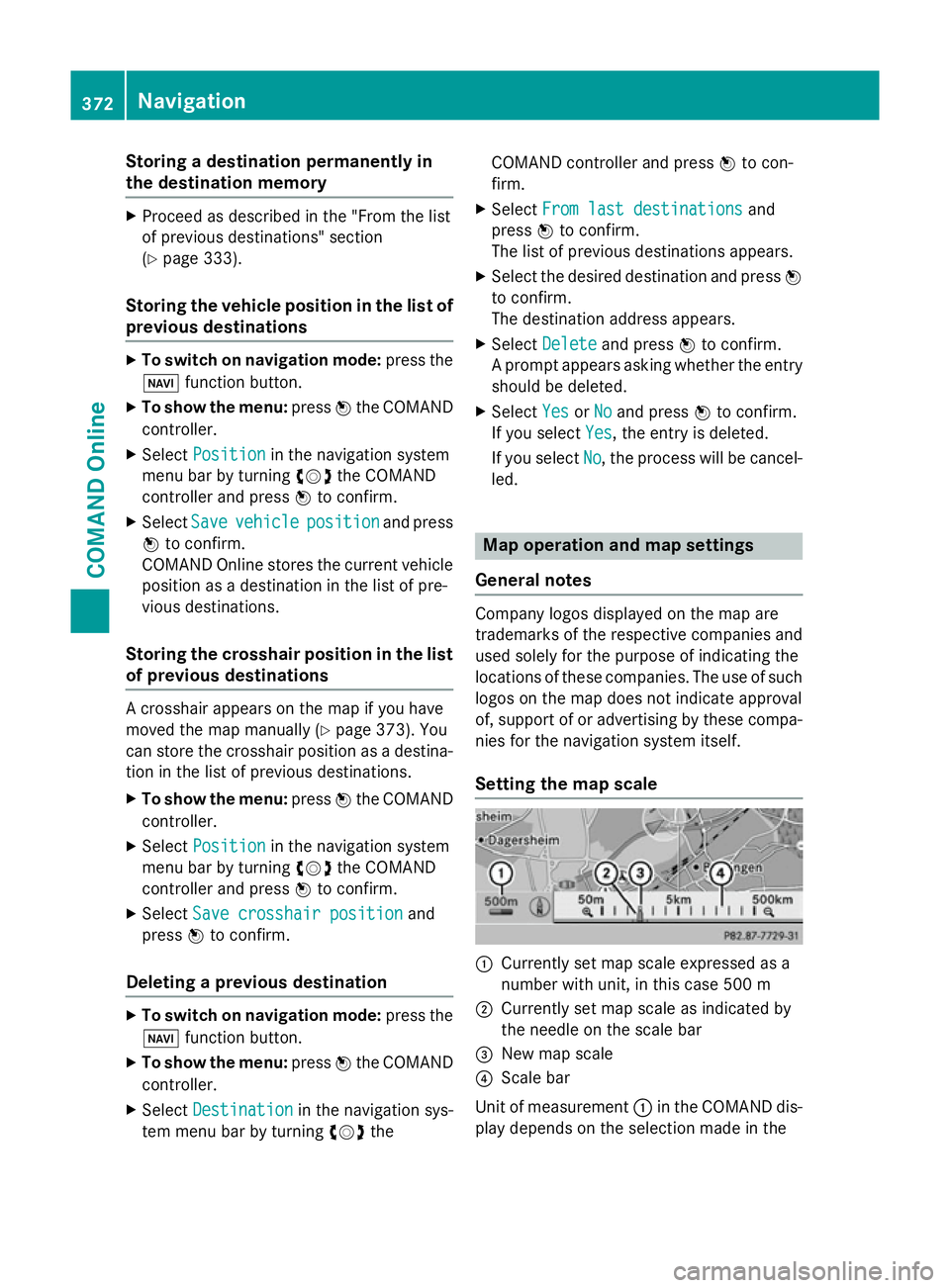
Setting the map scale :
Currently set map scale expressed as a
number with unit, in this case 500 m
; Currently set map scale as indicated by
the needle on the scale bar
= New map scale
? Scale bar
Unit of measurement :in the COMAND dis-
play depends on the selection made in the 372
NavigationCOMAND Online
Page 376 of 637
instrument cluster; see the separate vehicle
Owner's Manual.
X To hide the menu: slideZVthe COMAND
controller and, when the Full screen
Full screen
menu item is shown, press W.
X To call up the scale bar: as soon as you
turn cVd the COMAND controller, scale
bar ?appears.
X Turn cVd until the desired scale is set.
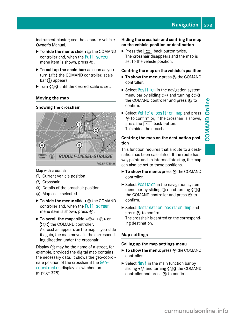
Moving the map Showing the crosshair
Map with crosshair
:
Current vehicle position
; Crosshair
= Details of the crosshair position
? Map scale selected
X To hide the menu: slideZVthe COMAND
controller and, when the Full screen Full screen
menu item is shown, press W.
X To scroll the map: slideXVY, ZVÆor
aVb the COMAND controller.
A crosshair appears on the map. If you slide
it again, the map moves in the correspond- ing direction under the crosshair.
Display =may be the name of a street, for
example, provided the digital map contains
the necessary data. It shows the geo-coordi-
nate position of the crosshair if the Geo-
Geo-
coordinates
coordinates display is switched on
(Y page 375). Hiding the crosshair and centring the map
on the vehicle position or destination
X Press the %back button twice.
The crosshair disappears and the map is
set to the vehicle position.
Centring the map on the vehicle's position
X To show the menu: pressWthe COMAND
controller.
X Select Position Position in the navigation system
menu bar by sliding VÆand turning cVd
the COMAND controller and press Wto
confirm.
X Select Vehicle position map
Vehicle position map and press
W to confirm or, if the crosshair is shown,
press the %back button.
This hides the crosshair.
Centring the map on the destination posi- tion
This function requires that a route to a desti- nation has been calculated. If the route has
way points and an intermediate stop, the map
can also be set to these positions.
X To show the menu: pressWthe COMAND
controller.
X Select Position Position in the navigation system
menu bar by sliding VÆand turning cVd
the COMAND controller and press Wto
confirm.
X Select Destination position map
Destination position map and
press Wto confirm.
The crosshair is centred on the correspond-
ing destination.
Map settings Calling up the map settings menu
X To show the menu: pressWthe COMAND
controller.
X Select Navi
Naviin the main function bar by
sliding ZVand turning cVdthe COMAND
controller and press Wto confirm. Navigation
373COMAND Online Z
Page 377 of 637
X
Select Map
Mapsettings
settings and pressWto con-
firm.
The map settings menu appears.
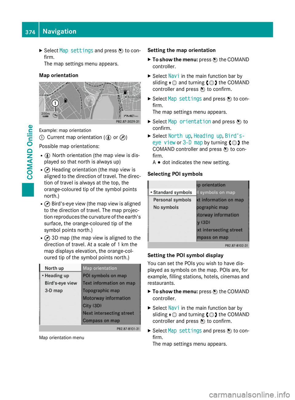
Map orientation Example: map orientation
:
Current map orientation (0 or¤)
Possible map orientations:
R 0 North orientation (the map view is dis-
played so that north is always up)
R ¤ Heading orientation (the map view is
aligned to the direction of travel. The direc-
tion of travel is always at the top, the
orange-coloured tip of the symbol points
north.)
R ¤ Bird's-eye view (the map view is aligned
to the direction of travel. The map projec-
tion reproduces the curvature of the earth's surface, the orange-coloured tip of the
symbol points north.)
R ¤ 3D map (the map view is aligned to the
direction of travel. At a scale of 1 km the
map displays elevation, the orange-col-
oured tip of the symbol points north.) Map orientation menu Setting the map orientation
X To show the menu: pressWthe COMAND
controller.
X Select Navi Naviin the main function bar by
sliding ZVand turning cVdthe COMAND
controller and press Wto confirm.
X Select Map
Mapsettings
settings and pressWto con-
firm.
The map settings menu appears.
X Select Map orientation Map orientation and pressWto
confirm.
X Select North up
North up, Heading up
Heading up, Bird's-
Bird's-
eye view
eye view or3-D map
3-D map by turning cVdthe
COMAND controller and press Wto con-
firm.
A # dot indicates the new setting.
Selecting POI symbols Setting the POI symbol display
You can set the POIs you wish to have dis-
played as symbols on the map. POIs are, for
example, filling stations, hotels, cinemas and
restaurants.
X To show the menu: pressWthe COMAND
controller.
X Select Navi Naviin the main function bar by
sliding ZVand turning cVdthe COMAND
controller and press Wto confirm.
X Select Map
Mapsettings
settings and pressWto con-
firm.
The map settings menu appears. 374
NavigationCOMAND Online
Page 378 of 637
X
Select POI
POI symbols
symbols on
onmap
map and press W
to confirm.
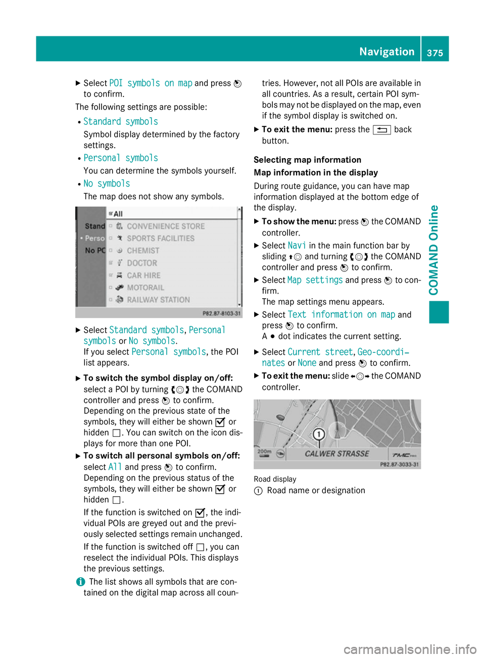
The following settings are possible:
R Standard symbols
Standard symbols
Symbol display determined by the factory
settings.
R Personal symbols
Personal symbols
You can determine the symbols yourself.
R No symbols
No symbols
The map does not show any symbols. X
Select Standard symbols Standard symbols, Personal
Personal
symbols
symbols orNo symbols
No symbols.
If you select Personal symbols Personal symbols, the POI
list appears.
X To switch the symbol display on/off:
select a POI by turning cVdthe COMAND
controller and press Wto confirm.
Depending on the previous state of the
symbols, they will either be shown Oor
hidden ª. You can switch on the icon dis-
plays for more than one POI.
X To switch all personal symbols on/off:
select All
All and press Wto confirm.
Depending on the previous status of the
symbols, they will either be shown Oor
hidden ª.
If the function is switched on O, the indi-
vidual POIs are greyed out and the previ-
ously selected settings remain unchanged.
If the function is switched off ª, you can
reselect the individual POIs. This displays
the previous settings.
i The list shows all symbols that are con-
tained on the digital map across all coun- tries. However, not all POIs are available in
all countries. As a result, certain POI sym-
bols may not be displayed on the map, even
if the symbol display is switched on.
X To exit the menu: press the%back
button.
Selecting map information
Map information in the display
During route guidance, you can have map
information displayed at the bottom edge of
the display.
X To show the menu: pressWthe COMAND
controller.
X Select Navi
Navi in the main function bar by
sliding ZVand turning cVdthe COMAND
controller and press Wto confirm.
X Select Map Mapsettings
settings and pressWto con-
firm.
The map settings menu appears.
X Select Text information on map Text information on map and
press Wto confirm.
A # dot indicates the current setting.
X Select Current street
Current street ,Geo-coordi‐
Geo-coordi‐
nates
nates orNone
None and press Wto confirm.
X To exit the menu: slideXVY the COMAND
controller. Road display
:
Road name or designation Navigation
375COMAND Online Z
Page 379 of 637
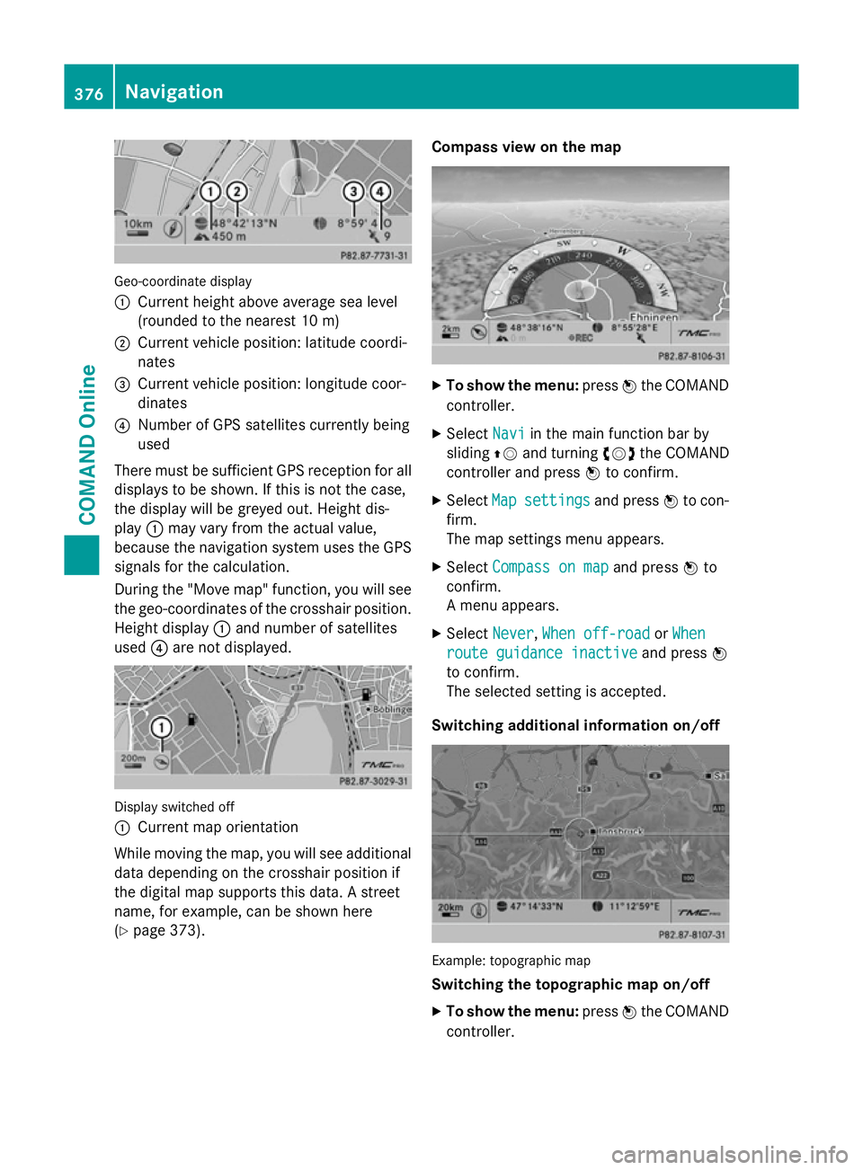
Geo-coordinate display
:
Current height above average sea level
(rounded to the nearest 10 m)
; Current vehicle position: latitude coordi-
nates
= Current vehicle position: longitude coor-
dinates
? Number of GPS satellites currently being
used
There must be sufficient GPS reception for all
displays to be shown. If this is not the case,
the display will be greyed out. Height dis-
play :may vary from the actual value,
because the navigation system uses the GPS
signals for the calculation.
During the "Move map" function, you will see
the geo-coordinates of the crosshair position. Height display :and number of satellites
used ?are not displayed. Display switched off
:
Current map orientation
While moving the map, you will see additional data depending on the crosshair position if
the digital map supports this data. A street
name, for example, can be shown here
(Y page 373). Compass view on the map
X
To show the menu: pressWthe COMAND
controller.
X Select Navi Naviin the main function bar by
sliding ZVand turning cVdthe COMAND
controller and press Wto confirm.
X Select Map
Mapsettings
settings and pressWto con-
firm.
The map settings menu appears.
X Select Compass on map Compass on map and pressWto
confirm.
A menu appears.
X Select Never Never, When off-road
When off-road orWhen
When
route guidance inactive
route guidance inactive and pressW
to confirm.
The selected setting is accepted.
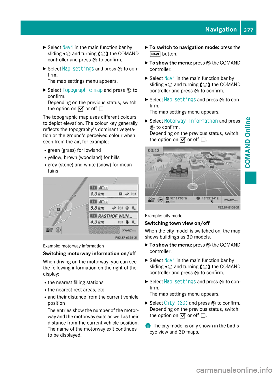
Switching additional information on/off Example: topographic map
Switching the topographic map on/off
X To show the menu: pressWthe COMAND
controller. 376
NavigationCOMAND Online
Page 380 of 637
X
Select Navi
Naviin the main function bar by
sliding ZVand turning cVdthe COMAND
controller and press Wto confirm.
X Select Map
Map settings
settings and pressWto con-
firm.
The map settings menu appears.
X Select Topographic map Topographic map and pressWto
confirm.
Depending on the previous status, switch
the option on Oor off ª.
The topographic map uses different colours
to depict elevation. The colour key generally
reflects the topography's dominant vegeta-
tion or the ground's perceived colour when
seen from the air, for example:
R green (grass) for lowland
R yellow, brown (woodland) for hills
R grey (stone) and white (snow) for moun-
tains Example: motorway information
Switching motorway information on/off
When driving on the motorway, you can see
the following information on the right of the
display:
R the nearest filling stations
R the nearest rest areas, etc
R and their distance from the current vehicle
position
The entries show the number of the motor- way and the motorway exits as well as their
distance from the current vehicle position.
The name of the motorway exit continues
to be displayed. X
To switch to navigation mode: press the
Ø button.
X To show the menu: pressWthe COMAND
controller.
X Select Navi
Navi in the main function bar by
sliding ZVand turning cVdthe COMAND
controller and press Wto confirm.
X Select Map Mapsettings
settings and pressWto con-
firm.
The map settings menu appears.
X Select Motorway information Motorway information and press
W to confirm.
Depending on the previous status, switch
the option on Oor off ª. Example: city model
Switching town view on/off
When the city model is switched on, the map
shows buildings as 3D models.
X To show the menu: pressWthe COMAND
controller.
X Select Navi Naviin the main function bar by
sliding ZVand turning cVdthe COMAND
controller and press Wto confirm.
X Select Map
Mapsettings
settings and pressWto con-
firm.
The map settings menu appears.
X Select City City(3D)
(3D)and press Wto confirm.
Depending on the previous status, switch
the option on Oor off ª.
i The city model is only shown in the bird's-
eye view and 3D maps. Navigation
377COMAND Online Z