MERCEDES-BENZ SL ROADSTER 2012 Owners Manual
Manufacturer: MERCEDES-BENZ, Model Year: 2012, Model line: SL ROADSTER, Model: MERCEDES-BENZ SL ROADSTER 2012Pages: 637, PDF Size: 20.68 MB
Page 381 of 637
It is available for the 50
mand 100 mmap
scales.
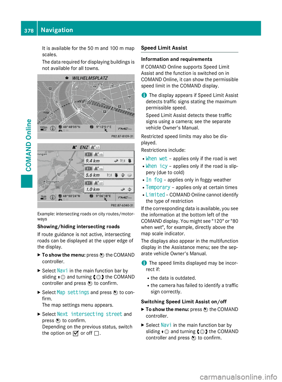
The data required for displaying buildings is not available for all towns. Example: intersecting roads on city routes/motor-
ways
Showing/hiding intersecting roads
If route guidance is not active, intersecting
roads can be displayed at the upper edge of
the display.
X To show the menu: pressWthe COMAND
controller.
X Select Navi
Navi in the main function bar by
sliding ZVand turning cVdthe COMAND
controller and press Wto confirm.
X Select Map
Map settings settings and pressWto con-
firm.
The map settings menu appears.
X Select Next intersecting street Next intersecting street and
press Wto confirm.
Depending on the previous status, switch
the option on Oor off ª. Speed Limit Assist Information and requirements
If COMAND Online supports Speed Limit
Assist and the function is switched on in
COMAND Online, it can show the permissible
speed limit in the COMAND display.
i The display appears if Speed Limit Assist
detects traffic signs stating the maximum
permissible speed.
Speed Limit Assist detects these traffic
signs using a camera; see the separate
vehicle Owner's Manual.
Restricted speed limits may also be dis-
played.
Restrictions include: R When wet
When wet – applies only if the road is wet
R When icy When icy – applies only if the road is slip-
pery (due to cold)
R In fog
In fog – applies only in foggy weather
R Temporary
Temporary – applies only at certain times
R Limited
Limited – COMAND Online cannot identify
the type of restriction
If the corresponding data is available, you see
the information at the bottom left of the
COMAND display. You might see "120" or "80 when wet", for example, directly above the
map scale indicator.
The displays also appear in the multifunction
display in the Assistance menu; see the sep-
arate vehicle Owner's Manual.
i The speed limits displayed may be incor-
rect if:
R the data is outdated.
R the camera has failed to identify a traffic
sign correctly.
Switching Speed Limit Assist on/off
X To show the menu: pressWthe COMAND
controller.
X Select Navi Naviin the main function bar by
sliding ZVand turning cVdthe COMAND
controller and press Wto confirm. 378
NavigationCOMAND Online
Page 382 of 637
X
Select Speed
Speed Limit
Limit Assist
Assist and press W
to confirm.
Depending on the previous status, switch
the option on Oor off ª. Additional settings
Avoiding an area General notes
COMAND Online enables you to avoid areas
you do not wish to drive through.
If you activate or deactivate a route block
while route guidance is active,
COMAND Online will calculate a new route. If
you activate or deactivate a route block while route guidance is inactive, COMAND Online
will use the new setting for the next route
guidance.
i Motorways within blocked areas are
always included in the route calculation.
Defining an area for the first time
X To switch to navigation mode: press the
Ø button.
X To show the menu: pressWthe COMAND
controller.
X Select Navi
Navi in the main function bar by
sliding ZVand turning cVdthe COMAND
controller and press Wto confirm.
X Select Avoid area
Avoid area and pressWto con-
firm.
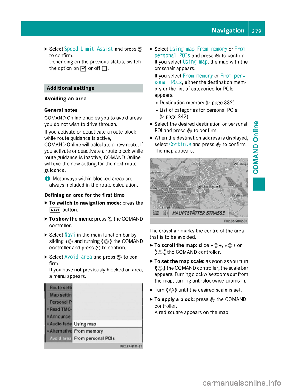
If you have not previously blocked an area, a menu appears. X
Select Using map Using map ,From memory
From memory orFrom
From
personal POIs
personal POIs and pressWto confirm.
If you select Using map
Using map, the map with the
crosshair appears.
If you select From memory From memory orFrom per‐
From per‐
sonal POIs
sonal POIs, either the destination mem-
ory or the list of categories for POIs
appears.
R Destination memory (Y page 332)
R List of categories for personal POIs
(Y page 347)
X Select the desired destination or personal
POI and press Wto confirm.
X When the destination address is displayed,
select Continue
Continue and pressWto confirm.
The map appears. The crosshair marks the centre of the area
that is to be avoided.
X To scroll the map: slideXVY,ZVÆ or
aVb the COMAND controller.
X To set the map scale: as soon as you turn
cVd the COMAND controller, the scale bar
appears. Turning clockwise zooms out from the map; turning anti-clockwise zooms in.
X Turn cVd until the desired scale is set.
X To apply a block: pressWthe COMAND
controller.
A red square appears on the map. Navigation
379COMAND Online Z
Page 383 of 637
X
To adjust the size of the square: turn
cVd the COMAND controller.
The square is enlarged or reduced.
X To confirm the settings: pressW.
The list appears. The previously selected
area to be avoided has been added and
activated.
You can define additional areas that you
would like to avoid (Y page 380).
Defining further areas
X To switch to navigation mode: press the
Ø button.
X To show the menu: pressWthe COMAND
controller.
X Select Navi
Navi in the main function bar by
sliding ZVand turning cVdthe COMAND
controller and press Wto confirm.
X Select Avoid area
Avoid area and pressWto con-
firm.
If you have already selected one or more
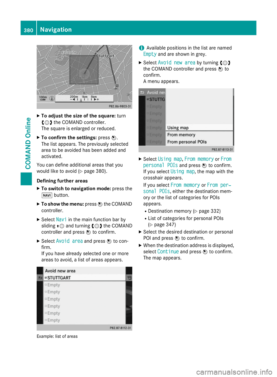
areas to avoid, a list of areas appears. Example: list of areas i
Available positions in the list are named
Empty Empty and are shown in grey.
X Select Avoid new area
Avoid new area by turningcVd
the COMAND controller and press Wto
confirm.
A menu appears. X
Select Using map Using map ,From memory
From memory orFrom
From
personal POIs
personal POIs and pressWto confirm.
If you select Using map
Using map, the map with the
crosshair appears.
If you select From memory From memory orFrom per‐
From per‐
sonal POIs
sonal POIs, either the destination mem-
ory or the list of categories for POIs
appears.
R Destination memory (Y page 332)
R List of categories for personal POIs
(Y page 347)
X Select the desired destination or personal
POI and press Wto confirm.
X When the destination address is displayed,
select Continue Continue and pressWto confirm.
The map appears. 380
NavigationCOMAND Online
Page 384 of 637
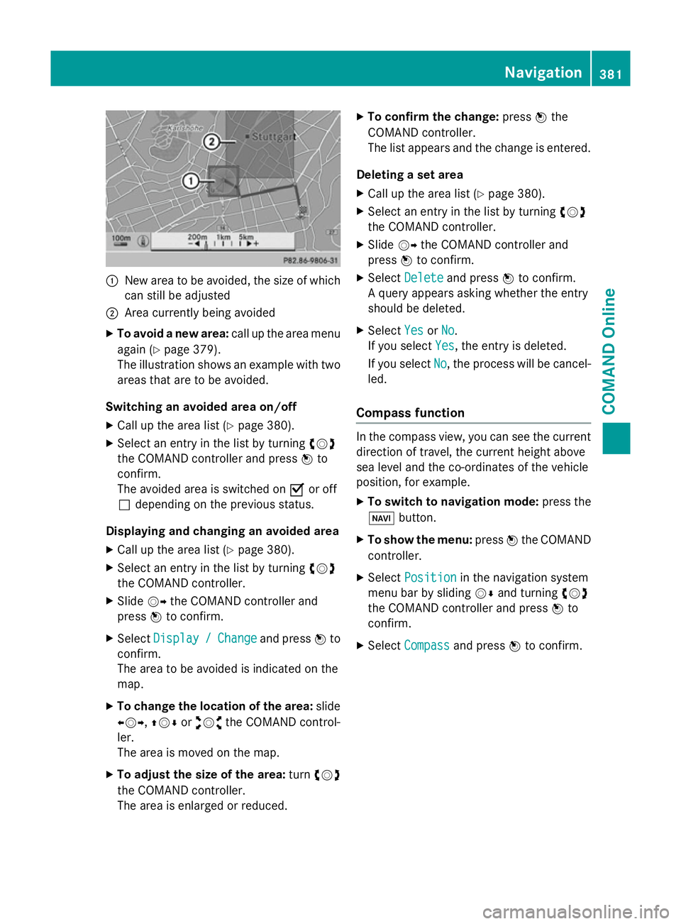
:
New area to be avoided, the size of which
can still be adjusted
; Area currently being avoided
X To avoid a new area: call up the area menu
again (Y page 379).
The illustration shows an example with two areas that are to be avoided.
Switching an avoided area on/off
X Call up the area list (Y page 380).
X Select an entry in the list by turning cVd
the COMAND controller and press Wto
confirm.
The avoided area is switched on Oor off
ª depending on the previous status.
Displaying and changing an avoided area X Call up the area list (Y page 380).
X Select an entry in the list by turning cVd
the COMAND controller.
X Slide VYthe COMAND controller and
press Wto confirm.
X Select Display
Display / /Change
Change and press Wto
confirm.
The area to be avoided is indicated on the
map.
X To change the location of the area: slide
XVY, ZVÆoraVb the COMAND control-
ler.
The area is moved on the map.
X To adjust the size of the area: turncVd
the COMAND controller.
The area is enlarged or reduced. X
To confirm the change: pressWthe
COMAND controller.
The list appears and the change is entered.
Deleting a set area
X Call up the area list (Y page 380).
X Select an entry in the list by turning cVd
the COMAND controller.
X Slide VYthe COMAND controller and
press Wto confirm.
X Select Delete
Delete and press Wto confirm.
A query appears asking whether the entry
should be deleted.
X Select Yes YesorNo
No.
If you select Yes
Yes, the entry is deleted.
If you select No
No, the process will be cancel-
led.
Compass function In the compass view, you can see the current
direction of travel, the current height above
sea level and the co-ordinates of the vehicle
position, for example.
X To switch to navigation mode: press the
Ø button.
X To show the menu: pressWthe COMAND
controller.
X Select Position Position in the navigation system
menu bar by sliding VÆand turning cVd
the COMAND controller and press Wto
confirm.
X Select Compass
Compass and press Wto confirm. Navigation
381COMAND Online Z
Page 385 of 637
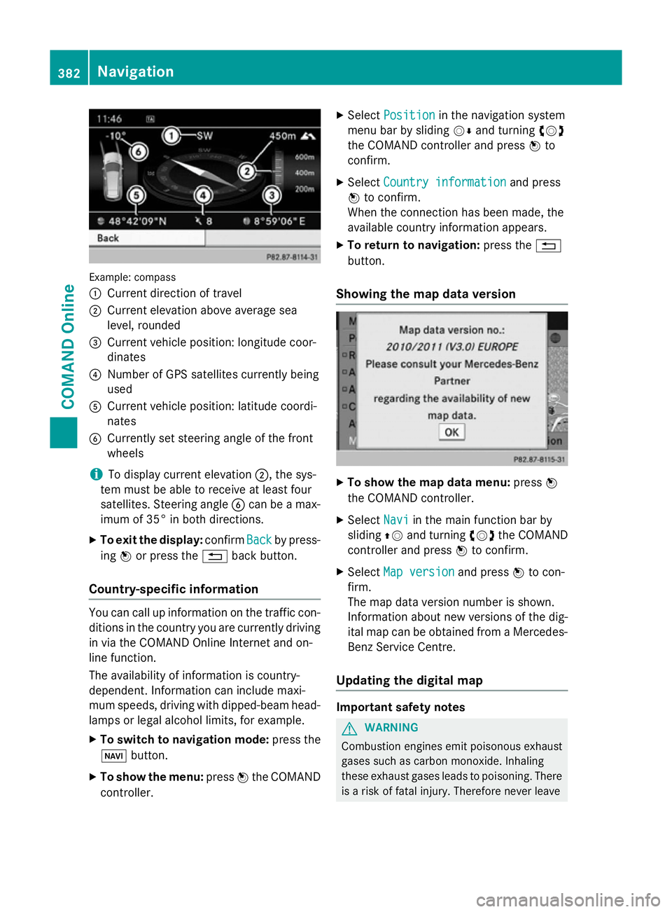
Example: compass
:
Current direction of travel
; Current elevation above average sea
level, rounded
= Current vehicle position: longitude coor-
dinates
? Number of GPS satellites currently being
used
A Current vehicle position: latitude coordi-
nates
B Currently set steering angle of the front
wheels
i To display current elevation
;, the sys-
tem must be able to receive at least four
satellites. Steering angle Bcan be a max-
imum of 35° in both directions.
X To exit the display: confirmBack
Back by press-
ing Wor press the %back button.
Country-specific information You can call up information on the traffic con-
ditions in the country you are currently driving
in via the COMAND Online Internet and on-
line function.
The availability of information is country-
dependent. Information can include maxi-
mum speeds, driving with dipped-beam head- lamps or legal alcohol limits, for example.
X To switch to navigation mode: press the
Ø button.
X To show the menu: pressWthe COMAND
controller. X
Select Position Position in the navigation system
menu bar by sliding VÆand turning cVd
the COMAND controller and press Wto
confirm.
X Select Country information
Country information and press
W to confirm.
When the connection has been made, the
available country information appears.
X To return to navigation: press the%
button.
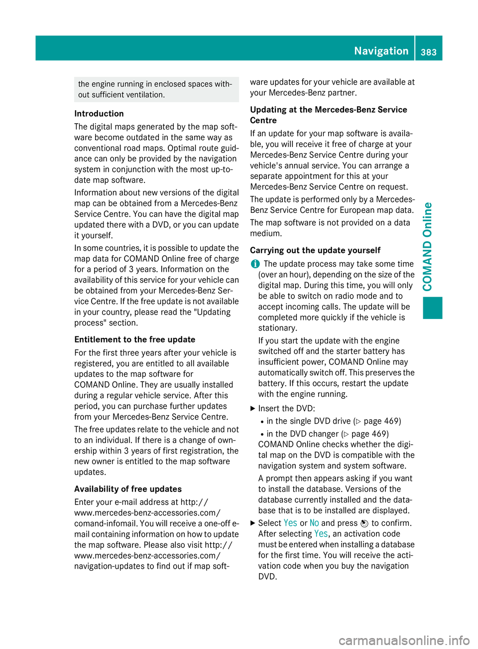
Showing the map data version X
To show the map data menu: pressW
the COMAND controller.
X Select Navi Naviin the main function bar by
sliding ZVand turning cVdthe COMAND
controller and press Wto confirm.
X Select Map version
Map version and pressWto con-
firm.
The map data version number is shown.
Information about new versions of the dig-
ital map can be obtained from a Mercedes- Benz Service Centre.
Updating the digital map Important safety notes
G
WARNING
Combustion engines emit poisonous exhaust
gases such as carbon monoxide. Inhaling
these exhaust gases leads to poisoning. There is a risk of fatal injury. Therefore never leave 382
NavigationCOMAND Online
Page 386 of 637
the engine running in enclosed spaces with-
out sufficient ventilation.
Introduction
The digital maps generated by the map soft-
ware become outdated in the same way as
conventional road maps. Optimal route guid-
ance can only be provided by the navigation
system in conjunction with the most up-to-
date map software.
Information about new versions of the digital map can be obtained from a Mercedes-Benz
Service Centre. You can have the digital mapupdated there with a DVD, or you can update
it yourself.
In some countries, it is possible to update the map data for COMAND Online free of charge
for a period of 3 years. Information on the
availability of this service for your vehicle can be obtained from your Mercedes-Benz Ser-
vice Centre. If the free update is not available
in your country, please read the "Updating
process" section.
Entitlement to the free update
For the first three years after your vehicle is
registered, you are entitled to all available
updates to the map software for
COMAND Online. They are usually installed
during a regular vehicle service. After this
period, you can purchase further updates
from your Mercedes-Benz Service Centre.
The free updates relate to the vehicle and not
to an individual. If there is a change of own-
ership within 3 years of first registration, the
new owner is entitled to the map software
updates.
Availability of free updates
Enter your e-mail address at http://
www.mercedes-benz-accessories.com/
comand-infomail. You will receive a one-off e- mail containing information on how to updatethe map software. Please also visit http://
www.mercedes-benz-accessories.com/
navigation-updates to find out if map soft- ware updates for your vehicle are available at
your Mercedes-Benz partner.
Updating at the Mercedes-Benz Service
Centre
If an update for your map software is availa-
ble, you will receive it free of charge at your
Mercedes-Benz Service Centre during your
vehicle's annual service. You can arrange a
separate appointment for this at your
Mercedes-Benz Service Centre on request.
The update is performed only by a Mercedes- Benz Service Centre for European map data.
The map software is not provided on a data
medium.
Carrying out the update yourself
i The update process may take some time
(over an hour), depending on the size of the
digital map. During this time, you will only
be able to switch on radio mode and to
accept incoming calls. The update will be
completed more quickly if the vehicle is
stationary.
If you start the update with the engine
switched off and the starter battery has
insufficient power, COMAND Online may
automatically switch off. This preserves the battery. If this occurs, restart the update
with the engine running.
X Insert the DVD:
R in the single DVD drive (Y page 469)
R in the DVD changer (Y page 469)
COMAND Online checks whether the digi-
tal map on the DVD is compatible with the
navigation system and system software.
A prompt then appears asking if you want
to install the database. Versions of the
database currently installed and the data-
base that is to be installed are displayed.
X Select Yes
Yes orNo No and press Wto confirm.
After selecting Yes
Yes, an activation code
must be entered when installing a database
for the first time. You will receive the acti-
vation code when you buy the navigation
DVD. Navigation
383COMAND Online Z
Page 387 of 637
If you select
No
No, the process will be cancel-
led.
X Enter the activation code.
After entering the activation code cor-
rectly, COMAND Online starts updating the
digital map. Once the update is finished,
you will see a message.
X To confirm the message: pressWthe
COMAND controller.
X Take the DVD out of the slot.
While the update is running, you will see a
message to this effect and a progress bar.
The navigation system is not operational
until the update is complete.
i You cannot eject the DVD during the
update. If you switch off COMAND Online
during the update, the update is interrup-
ted. It then continues from where it was
interrupted when the system is restarted.
COMAND Online may prompt you to change
the DVD during the update.
X Press the V(for DVD changer) or 8
(for single DVD drive) load/eject button.
X Take the DVD out of the slot.
X Insert the requested DVD.
Once the update has been successfully
completed, you will see a message to this
effect.
X To confirm the message: pressWthe
COMAND controller.
X Take the DVD out of the slot.
The update is complete.
If the update is not successfully completed,
you will see a message that the map update is not possible.
X To confirm the message: pressWthe
COMAND controller.
X Take the DVD out of the slot. 384
NavigationCOMAND Online
Page 388 of 637
Problems with the navigation system
Problem
Possible causes/consequences and
M
MSolutions COMAND Online is
unable to continue
route guidance after
the journey has been
interrupted. Route guidance is cancelled if you interrupt the journey for more
than two hours.
"Interrupting the journey" refers to stopping the vehicle.
"Continuing route guidance" refers to switching COMAND Online
back on and driving on.
X Continue route guidance (Y page 356).Problem
Possible causes/consequences and
M MSolutions COMAND Online is
unable to determine
the vehicle's position. COMAND Online has to redetermine the position of the vehicle if
the vehicle has been transported.
Examples:
R after transporting the vehicle by ferry
R after transporting the vehicle by motorail
R after the vehicle has been towed
X Start the vehicle and pull away.
COMAND Online determines the vehicle's position. Depending
on the driving situation, this may take some time.
Route guidance may be restricted during the determination of
the vehicle's position.
When positioning is complete, route guidance is resumed with
navigation announcements and route guidance displays. Navigation
385COMAND Online Z
Page 389 of 637
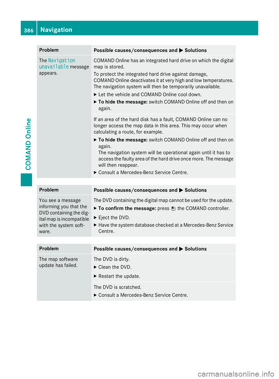
Problem
Possible causes/consequences and
M
MSolutions The
Navigation
Navigation
unavailable
unavailable message
appears. COMAND Online has an integrated hard drive on which the digital
map is stored.
To protect the integrated hard drive against damage,
COMAND Online deactivates it at very high and low temperatures. The navigation system will then be temporarily unavailable.
X Let the vehicle and COMAND Online cool down.
X To hide the message: switch COMAND Online off and then on
again. If an area of the hard disk has a fault, COMAND Online can no
longer access the map data in this area. This may occur when
calculating a route, for example.
X To hide the message: switch COMAND Online off and then on
again.
The navigation system will be operational again until it has to
access the faulty area of the hard drive once more. The message will then reappear.
X Consult a Mercedes-Benz Service Centre. Problem
Possible causes/consequences and
M MSolutions You see a message
informing you that the
DVD containing the dig-
ital map is incompatible
with the system soft-
ware. The DVD containing the digital map cannot be used for the update.
X To confirm the message: pressWthe COMAND controller.
X Eject the DVD.
X Have the system database checked at a Mercedes-Benz Service
Centre. Problem
Possible causes/consequences and
M MSolutions The map software
update has failed. The DVD is dirty.
X Clean the DVD.
X Restart the update. The DVD is scratched.
X Consult a Mercedes-Benz Service Centre. 386
NavigationCOMAND Online
Page 390 of 637
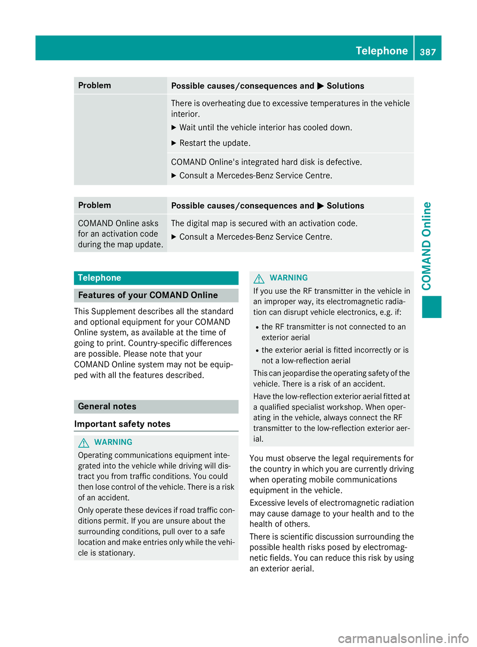
Problem
Possible causes/consequences and
M
MSolutions There is overheating due to excessive temperatures in the vehicle
interior.
X Wait until the vehicle interior has cooled down.
X Restart the update. COMAND Online's integrated hard disk is defective.
X Consult a Mercedes-Benz Service Centre. Problem
Possible causes/consequences and
M
MSolutions COMAND Online asks
for an activation code
during the map update. The digital map is secured with an activation code.
X Consult a Mercedes-Benz Service Centre. Telephone
Features of your COMAND Online
This Supplement describes all the standard
and optional equipment for your COMAND
Online system, as available at the time of
going to print. Country-specific differences
are possible. Please note that your
COMAND Online system may not be equip-
ped with all the features described. General notes
Important safety notes G
WARNING
Operating communications equipment inte-
grated into the vehicle while driving will dis-
tract you from traffic conditions. You could
then lose control of the vehicle. There is a risk of an accident.
Only operate these devices if road traffic con-
ditions permit. If you are unsure about the
surrounding conditions, pull over to a safe
location and make entries only while the vehi- cle is stationary. G
WARNING
If you use the RF transmitter in the vehicle in
an improper way, its electromagnetic radia-
tion can disrupt vehicle electronics, e.g. if:
R the RF transmitter is not connected to an
exterior aerial
R the exterior aerial is fitted incorrectly or is
not a low-reflection aerial
This can jeopardise the operating safety of the vehicle. There is a risk of an accident.
Have the low-reflection exterior aerial fitted at
a qualified specialist workshop. When oper-
ating in the vehicle, always connect the RF
transmitter to the low-reflection exterior aer-
ial.
You must observe the legal requirements for
the country in which you are currently driving
when operating mobile communications
equipment in the vehicle.
Excessive levels of electromagnetic radiation
may cause damage to your health and to the
health of others.
There is scientific discussion surrounding the possible health risks posed by electromag-
netic fields. You can reduce this risk by using
an exterior aerial. Telephone
387COMAND Online Z